This is more of a report from the technical perspective of what we did and what we discovered.
The original plan: Two cars heading up to do some trail building/improvement for the Harrison Hut trail. Car1 (of 5) arrive on Friday evening and leave on Sunday evening; Car2 (of 4) arrive on Saturday morning and leave on Tuesday evening to enjoy an extended Canada Day long weekend. Car1 will focus on working on the trail as much as possible, joining by Car2 on Saturday afternoon and Sunday. Car2 will continue working on the trail a bit longer when Car1 leaves, and to the hut: aiming to hang markers along the way for some sections where trail markers are sparse (around Barr Creek to Hut); then they will enjoy one day of hiking/scrambling around the hut; on their way down, if capacity allows, they will help carry the handline chain from the hut to the first handline they meet so the future group can install it with tools.
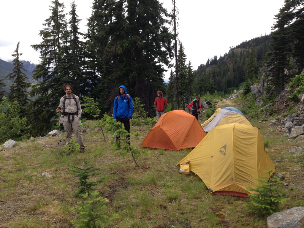
What actually happened: Car1 arrived on Friday night and camped at the trailhead, left shortly after 8am on Saturday morning. It took us a bit less than 3 hours to arrive at our campsite just before entering the second section of the trail on the logging road; with a nice view of Pylon, Devastator, Meager and Capricorn.
After setting up tents and lunch, we set out for some exploring to have a personal feel of what/where needs to be done according to the words from people who worked there before and are more familiar with the condition of the trail. We hiked to Pika Creek in no time, dropped our tools there (because there was enough work for us to do before Pika Creek) and adventured a bit further to observe the “standard” switchback Christian had told me to follow. We had to be somewhat inventive to cross Pika Creek: I threw some big rocks in one section to make it close enough to jump through, some others carried a giant log and made a bridge for some balancing walk. Not sure if either way will still be there the next time someone goes.
We didn’t need to adventure too far beyond to see how a good trail is built from those switchbacks immediately after Pika Creek. Having a general idea of what needed to be done and excited for some work, we came back, picked up the tools and divided into a group of 3 and a pair. Each group picked a section close to Pika Creek and started laying down logs and rocks before cutting slopes and paving dirt on top. The general idea was to make all sidehilling more smooth and comfortable to walk on. Use logs to stable a slope and cut a flat profile for steep sections, chop and pave for the shallow sections, then leave the very steep and long sections to another time (chainsaws and big logs). The beginning was definitely a trial and error learning experience: both teams needed a couple of times to figure out a best solution for the different problems we faced. We worked hard for a few hours each day but it was a fun and rewarding process to get some before-and-after effect, like the side-by-side photos show below. We won’t know how good the results will be (i.e. how long they’ll hold) for the sections we changed – rainfall and landslide can easily destroy some work, I believe – but it’ll be interesting to see when the seasons pass by.
Around 5pm, Moos from Car2 showed up. He brought a couple of bad news: Erica fell in the first clearcut, injured her knee and could barely walk; and there was a group of 18 people party going down to the Meager hot spring – which made us completely abandoned the discussion of a possible trek to the hot spring with the long daylight and reward our hard working day. We finished work around 6pm and headed back to camp to meet with the other three. Dinner ensued, with good conversations by fire before we all retrieved to some well-deserved rest after dark.
There were brief discussions of alternative plans because of the unexpected injury to Erica, but to the best interest of the team and minimize the possibility of further unforeseen incidents, everyone was understanding and cooperative: we decided to head back together on Sunday. We got up around 7am on Sunday, Erica and Rob took their time to hike back to car while the other 7 of us worked about another 5 hours on the same section and brought it to a good condition. Around 2pm, we took down our tents and returned to the cars. Along the way, we put up some more markers for a few parts and cleaned some fast growing tree branches that made our markers hidden. In the end, we noticed the mosquitoes situation was a lot more horrific at the trailhead than where we camped, so we packed up as quickly as possible before being eaten alive by clouds of them and enjoyed a beautiful long drive home.
For the future:
1.) The first clearcut is already pretty overgrown – a machete will be hugely helpful. There were also a couple of sections of steep sidehilling on the first section of the trail that could need some work – I remember one part in between the two clearcuts not long after getting out of the first one was pretty bad. The hot spring crowd could make some sections worse by continuously kicking down the slides.
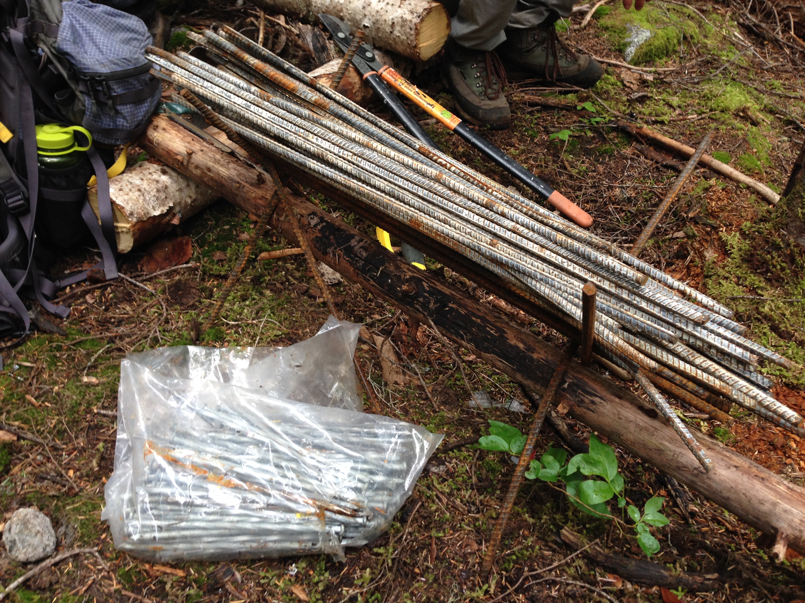
2.) I found two stashes of rebars and steel spikes on either side of Pika Creek. The first one (shown in the picture below), is after the high point of the ridge going to Pika Creek from the logging road in that small section of open forest, just after a small uphill ramp, on the right side of the trail (heading toward hut). Tom took GPS coordinates of this location. It’s not hard to see if you are looking around – that being said, I was the only one saw it the first time passing by (maybe because I was particularly looking since Christian told me to) – same applies to the second smaller batch of rebars, hiding in a white plastic bag on the left side of the trail after Pika Creek (again, heading toward hut), definitely less than 5 min after the creek before (or around) the first switchbacks. We didn’t take photo of GPS coordinates of this cache – but if you pay attention looking, you should be able to see it.
3.) All the signs were bundled together and hung on the big tree just before Pika Creek (same direction to the hut) with a blue rope by the handline – shouldn’t be difficult to see those. See the photo below.

4.) Tools: We found hoes were a lot more useful than shovels in cutting sidehills, so I’d bring 3:1 ratio of hoes to shovels instead of 1:1. I did not know there were already many steel spikes up there with the first cache of rebars we found, so I bought and brought up more – they are together now, but we definitely don’t need more. We carried more than half of the rebars we brought in our car and put them together with the first cache, the rest are behind the big stump at the trailhead where the sign was hung. I also bought a box of (10?) aluminium gutter spikes for hanging those signs by the creek, but we didn’t use them because we didn’t bring the signs up to where they belong. The next group can certainly take what I bought and use them. I bought a few more pairs of gloves as well, they are with the tools in the clubroom now for future use. One bow saw was missing a screw to hold the saw on one end, it was duct taped – we didn’t notice it and brought the useless thing up – we should fix it or set it aside.
5.) The two (side-by-side) pictures below is one steep sidehill section gaining the top of the ridge after the logging road toward Pika Creek. (Picture on the right side shows the view looking back.) The current trail goes somewhat like the red coloured line, down a bit and then back up. We were wondering if keeping it more levelled (i.e. the blue coloured line) is a better option – it definitely needed a bigger log to hold the slope, which we didn’t have the capacity of doing so left behind. I think it’s worth another look.
This is pretty much all I recall. If other participants remember more of what we saw/discussed, please comment here – it’ll be hugely helpful for future trips. I’m glad I went on the trip and now have a better idea of the condition of the trail
Last but not least, I want to thank the participants again for helping out! Martin and Brianne were going for a relaxing weekend to the hut but ended up working like mules; Conrad came out off his vacation time in Vancouver to help; Tom is still dealing with back issues and carried heavy loads; Natalie jumped in as the second driver and pretty much made this trip happen (I was going to cancel it if it were only one car), and she and Moos were both quite understanding to cut their weekend short and went with the group decision to make sure we all got home safely; Although Erica and Rob didn’t help on the trail building, she toughed it out with a very bad knee, hiked in and out on her own power so we didn’t need to worry about her and got more work done. You all deserve an applaud – thanks again!
Looking forward to seeing more other faces and getting some work done this summer on the trails and huts!
Thanks for the report, Shane!
At number (4), I think you mean mattocks instead of hoes. They’re slightly different!
For the bad sidehill shown at (5), another option would be to go high, between those two trees that can be seen on the far left of the picture. The ground up there seemed a little less loose and there are good places to put logs.
Oh, google tells me I was wrong about the hoe/mattock thing. Ignore me!
I used Google ahead of time to make sure I sounded like I knew what I was talking about…
Yes in #5 the blue line is preferred. It’s a more consistent slope, which mean easier hiking and less erosion too. From the photo it looks like you might also be able to do a full bench cut to create a level trail along the blue line, but that’s a lot of work.
Oh yeah, blue lines for sure. The current footbed is not in any well-chosen location – it’s just the result of where people happen to have been walking already.
Thanks for the report and the work!