Participants: Matteo Agnoloni and Kevin Burton
Date: July 24 – July 28, 2016
Driving along the Sea-to-Sky highway, it is hard to avoid the beauty that is the Tantalus Range. Its rugged peaks make up a skyline that attracts attention from everyone ranging from your everyday tourists to world class mountain guides. For a long time, I have wanted to make a trip to this area. Though, initially, it just started with wanting to hike up to Lake Lovely Water. As I climbed more mountains and acquired more skills, I started to think about harder objectives I could tackle. I had interests in climbing Alpha, Serratus, Dione, and Tantalus, but no plan as to which ones or what routes. My job wouldn’t start until September, so I was hoping I could spend a decent amount of time in the area and try to climb all of them. I posted a trip on the calendar to try and find potential partners. People were interested, people bailed, and weather was uncertain. I started to worry if this would ever happen. Then, a glimmer of hope emerged; a week of clear blue skies was forecasted for the last week of July. But alas, I had no climbing partner.
I had a friend, Kevin Burton, who also had minimal responsibilities this summer, so I asked him if he would be up to spend some time in the Tantalus Range. He was stoked on the idea, but he had little to no glacier or snow experience. I took some time to think about what we could do. It then dawned on me that the best way to climb all four of the major peaks was to traverse the range. The idea of completing the Tantalus Enchainment entirely by foot sure was tempting. I researched the route, and it seemed there was only a short section of mellow glacier travel between the Jim Haberl Hut and Dione. I somehow sold Kevin on this idea.
Alpine Select describes the Tantalus Enchainment as follows:
TD 5.8 – Highly recommended. This is a fine adventure over 11km of superb alpine terrain, best done in a north-south direction; long on distance and moderate climbing, but demanding skill at routefinding and speed…An entirely by-foot approach would be an arduous affair and render this traverse into a 28km, 3- or 4-day affair.
28km didn’t seem that long, and we both really wanted to get our Squamish-River-cable-car-crossing-cherries popped. We also decided to go in a south-north direction because so many good things had been said about the east ridge of Alpha. We planned to finish in four days. I was super excited that everything was falling in to place for a grand adventure.
Day 1: The Squamish River Epic
We arrived at the yellow gate on the Squamish Valley Road at approximately 8am. There were three cars parked there and we stopped to check if they had received any tickets. Each car had a sticker on their windshield from the Squamish Reserve Authorities warning that they would be towed if they did not remove their car in 15 days. We both thought this was extremely generous. There is a dirt road less than 100m south of the yellow gate that allows you to drive all the way to the cable car tower. We took this route, and my uber low clearance 2WD Ford Focus had no problems making it to the tower. We did some final organizing of our gear and then set off to cross the river. There is a locked chain keeping the gate to the tower closed, but the chain is loose so you can sneak through if you are slenderly built. You can also climb the side of the gate since it seems someone has cut the barbed-wire at the top.

Matteo squeezing through the gate to the cable car tower. Photo: Kevin Burton
Once at the top of the tower, Kevin expressed interest in crossing first. I had no problem with this, and actually preferred it as I could observe him and improve my strategy to cross. Kevin set off, and decided to wear his backpack as opposed to clipping it directly to the upper cable and dragging it. He easily made it to the first giant air traffic cone.
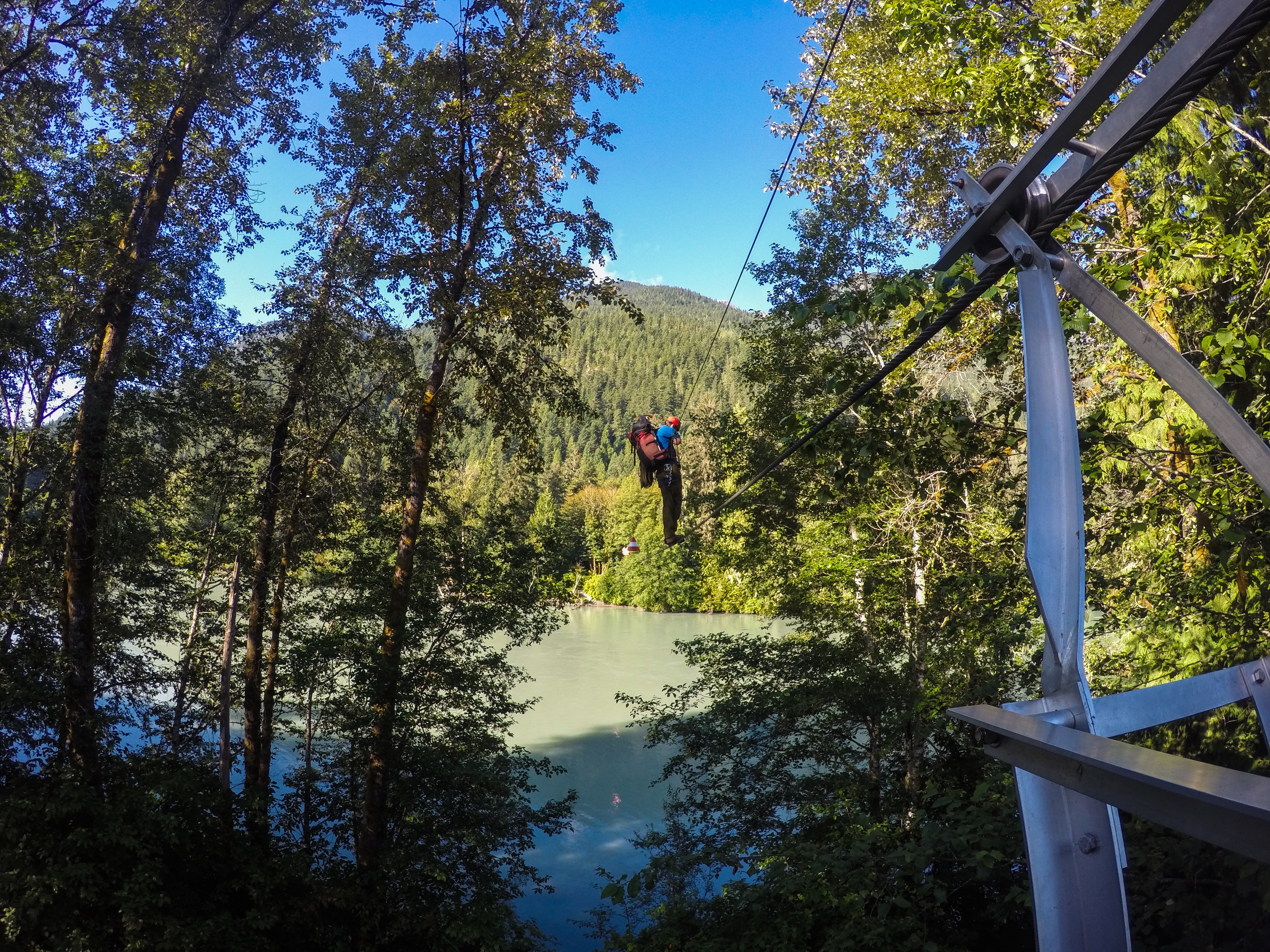
Kevin looking good crossing the Squamish River. Photo: Matteo Agnoloni
At this point, things started to get really wobbly. Kevin would take one step forward and then spend a good amount of time wobbling back and forth trying to regain balance. Occasionally, the shaking got so bad he had to sit down on the lower cable in order to stabilize himself. As he approached the second cone, Kevin yelled over to me:
Kevin: Dude! I’m so pumped!
Matteo: Lookin’ solid dude!
Kevin: How long has it been?
Matteo: Uhh…about an hour.
Kevin: Shiiiiiit!
As Kevin passed the second cone, I continued to shout extremely helpful advice, such as “You got this!” and “You’re totally killin’ it!” The shaking got REALLY bad past the second cone, and it became apparent that Kevin’s loosely fitted backpack was the cause of the issues. Kevin struggled to the third cone. I took a look at my watch and it had now been two hours since he had started. I was starting to get really nervous for my attempt at the crossing. I dazed off for a few moments, recalculating our schedule for the day. The original plan was to climb Alpha’s east ridge the first day and bivy somewhere in the Alpha-Serratus col. Maybe we would have to reassess once we were both over the river. SCHWWAACKK! All of a sudden, both of the cable car wires were vibrating violently. I looked up to see Kevin dangling upside down below both cables, struggling to pull himself back up. At first, though I feel guilty to admit it, I let out a little chuckle. Maybe it was more than a little chuckle. I think I actually had a good laugh. It seriously looked quite comical. This feeling was short-lived as I started to realize how much trouble he was in.
“Holy shit…How is he going to get back up? Holy shit… what if his harness isn’t tight enough and he slips out in to the river? Holy shit… What if I have to rescue him?!”
I shit you not, Kevin was hanging upside down for a good 20 minutes. He had almost managed to reach for the upper cable and pull himself back up, but the weight of his overnight pack with 4+ days’ worth of food was weighing him down too much. Kevin called over to me:
Kevin: Matteo! I think I need you to rescue me.
Matteo: Uhh… okay! Give me one second! ***whispers to himself*** What the fuck am I going to do?!
I collected some extra gear, with the idea that when I reached him, I would try and clip his backpack to the upper cable so that he could take his backpack off and climb back up. I had never been so nervous. I worked my way across the cable and passed the first cone. At the same time, Kevin was still trying to pull himself back up. I yelled over to him to stop moving as he was shaking the cables quite hard. Then, as I was making my way across, two people in a canoe came down the river. I cannot even begin to describe to you the look on their faces when they saw Kevin dangling upside down with no hope in hell of getting back up. They were on their way back from Lake Lovely Water, so they canoed over to the cable car tower. They sat there watching for a couple minutes, and then yelled up to me, asking if Kevin wants to drop his pack in to the river while they canoed under us. I relayed the information to Kevin. He said, “Yeah, maybe.” The two good Samaritans started paddling up stream. I had this grand vision that Kevin and the two canoers would time the dropping of the pack to perfection, resulting in the pack landing perfectly in the canoe. Yeah fucking right. Then, as the canoers continued upstream, somehow, by the grace of all that is good, Kevin managed to sling a piece of his pack and clip it to the upper cable. He was free. He climbed back up and yelled over to the canoers to thank them for their offering of aid. I made my way back to the start of the cable crossing. I looked at my watch. Kevin had been dangling upside down for at least 30 minutes. He gathered his composure and completed the crossing at pretty much exactly the three hour mark.
My crossing was uneventful. I took advantage of Kevin’s suffering and clipped my backpack to the upper cable and dragged it behind me. I made it across in 30 minutes and applauded Kevin’s determination. He would later admit to me that whilst upside down, his legs went completely numb and he almost puked.
After a much deserved break, it was now about 12:30pm. Kevin was totally worked, and it didn’t look like we were going to make it up and over Alpha. We still needed to cover as much ground as possible. We pushed through the slog that is the Lake Lovely Water trail. Once at the Tantalus hut, we stopped inside for a quick snack break. There was a large group of late-20-something-year-olds, kitted out with jean shorts and snap-back caps. One woman asked me:
Random Woman: Where are you guys coming from?
Matteo: The river.
She seemed confused with my response. I guess she was asking where we were actually from, since everyone there seemed to have flown in by helicopter. I didn’t have the energy to carry on a conversation.
After some fuel, we continued on, with our new goal being to set up camp at the shoulder of the east ridge of Alpha. There is a trail that leads directly to the shoulder. At first you walk along the shores of Lake Lovely Water, and then you arrive at a fork. Going left leads to Lambda Lake and going right is the approach trail for the east ridge of Alpha. The trail is quite steep but very easy to follow. By 7:00pm, we were on the shoulder of Alpha. We set up camp in a very picturesque spot with views of the minor Tantalus range peaks, ate dinner, and set our alarms for 4am. The next day, we planned to climb up and over Alpha, climb the east ridge of Serratus, and descend towards the Jim Haberl Hut.
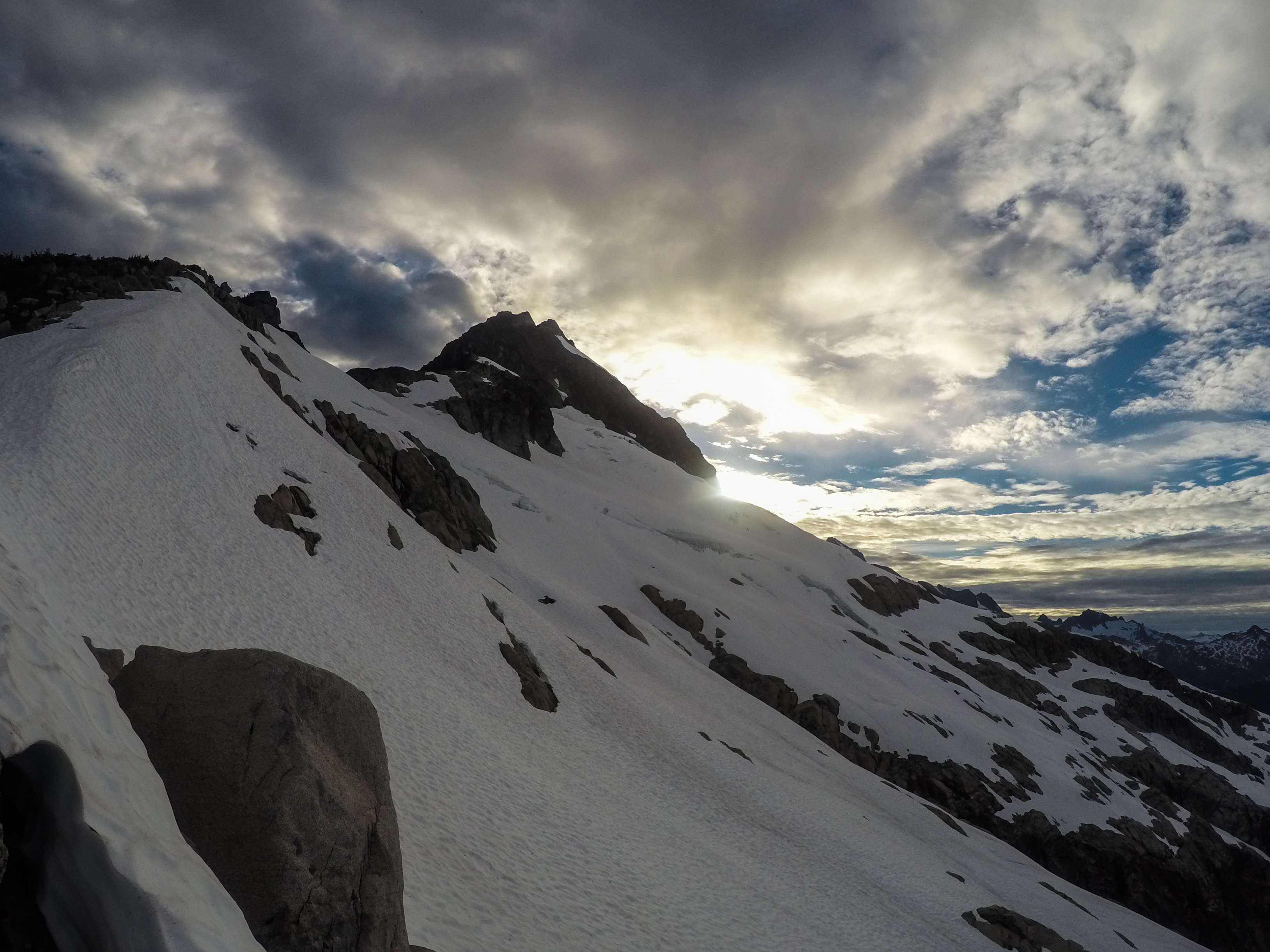
The east ridge of Alpha as the sun sets. Photo: Matteo Agnoloni
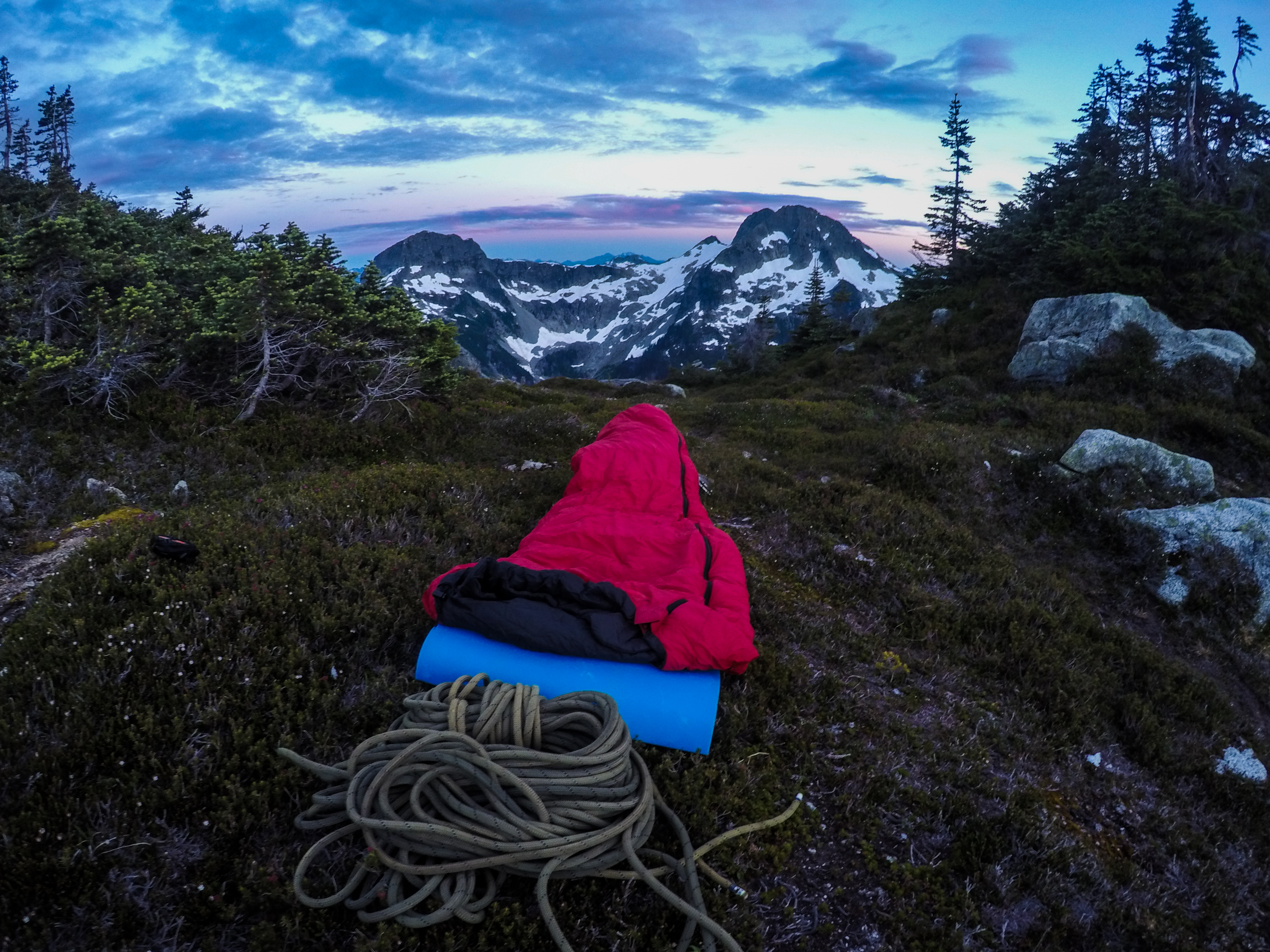
Bivy with a view. Photo: Matteo Agnoloni
Day 2: The Deceptive Rappel Route
Our 4am wake-up time came a little faster than we had been hoping for. I woke up, had breakfast in bed, and started packing my gear. Kevin was still a bit tired from yesterday’s ordeal, so he took a bit longer to get up. I pleaded with him that we had a very long day ahead of us in order to make up for lost time.
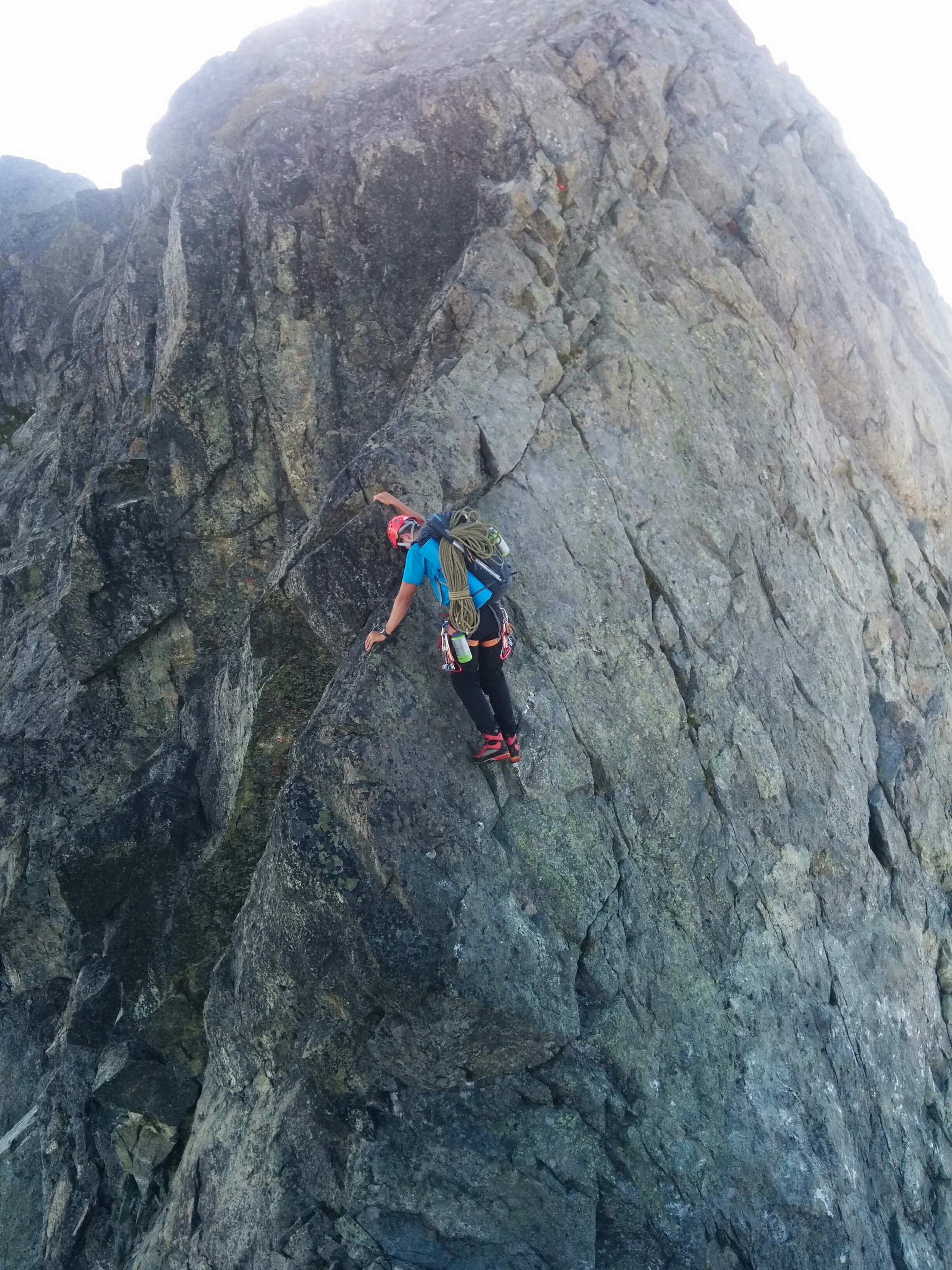
With everything packed up, we started heading towards the east ridge. We stayed on the snow covered north side of the ridge until we reached sections of easy ridge walking. The crux of the route is very obvious and is even marked with a cairn and flagging. You drop down in to a notch and scramble up a couple meters to a thin crack that gradually widens up higher with a slight overhang. I started flaking out the rope and I asked Kevin if I could lead the crux pitch. He happily obliged.
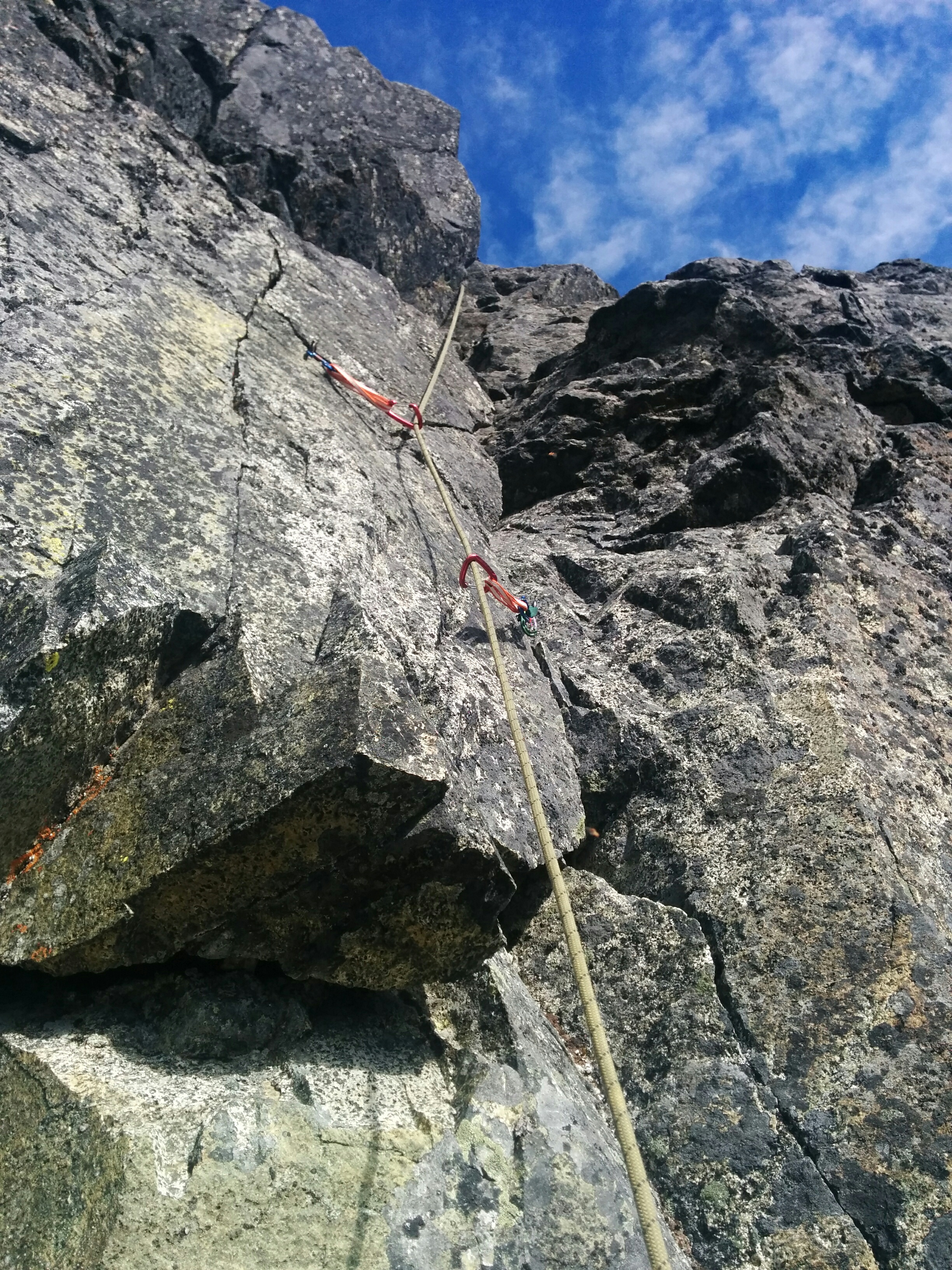
Beta photo for the 5.7-5.8 crux pitch on Alpha’s east ridge. Photo: Kevin Burton
There is not much protection for the crux pitch. If I recall, I placed one nut and one #0.75 C4 not too far off of the ground. There was an old piton that I made use of. It seemed pretty solid. If you really wanted to, you could lug up a #4 C4 to protect the upper half of the crux. I belayed Kevin up off of a giant block, and from there we remained unroped to the summit of Alpha. We pretty much stuck to the ridge crest and only deviated slightly to the left or the right if the climbing looked a lot easier there.
Kevin scrambling with beautiful views of Lake Lovely Water in behind. Photo: Matteo Agnoloni
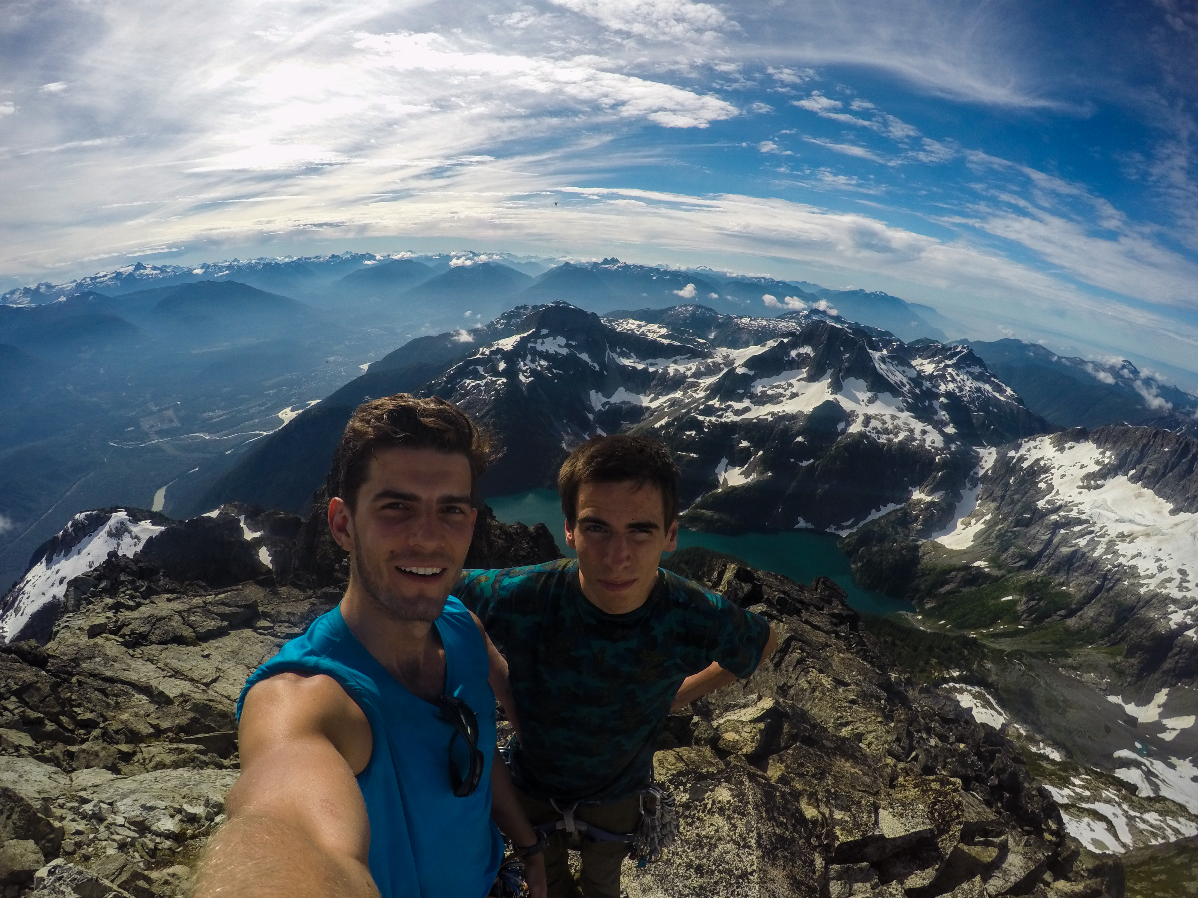
Alpha summit selfie! Photo: Matteo Agnoloni
On top of Alpha, we had amazing blue skies and a clear view of Lake Lovely Water, as well as our destination for the next few days. We took a short break, had some food, and began our descent towards the east ridge of Serratus. We followed the instructions for the descent route in Alpine Select. We scrambled down the southern face of Alpha until we came upon a small gulley leading to the snowy western flank. It went really smoothly and Kevin even found an ice screw in excellent condition.
We managed to make our way over to the Alpha-Serratus col, which involved a sketchy moat crossing and some extremely chossy rock. From here, the east ridge of Serratus looked absolutely massive, and we couldn’t even see half of it. In Alpine Select, it is described as being seamed with innumerable gendarmes, offering classic mountaineering on terrain that is mostly 3rd class. Spectacular though it appears, the rock is poor. Do not take this description lightly. The terrain is mostly 3rd class if, and only if, you have near perfect route finding. It is very easy to make a mistake routefinding and find yourself on 5th class terrain. We made this mistake a couple times and found ourselves having to very carefully downclimb 5th class terrain.
The biggest difficulty for us was finding an easy route to the top of the first main pinnacle of the ridge. We made two poor decisions and found ourselves trying to climb some pretty tough spots. Also, the description about the poor rock quality is a bit of an understatement. The rock quality is fucking horrible. We had to double check each hand and foot placement in order to ensure we wouldn’t release any death blocks on to each other. This definitely slowed down the climbing and increased our mental fatigue.
Kevin working his way around one of the many choss-littered gendarmes. Alpha in behind. Photo: Matteo Agnoloni
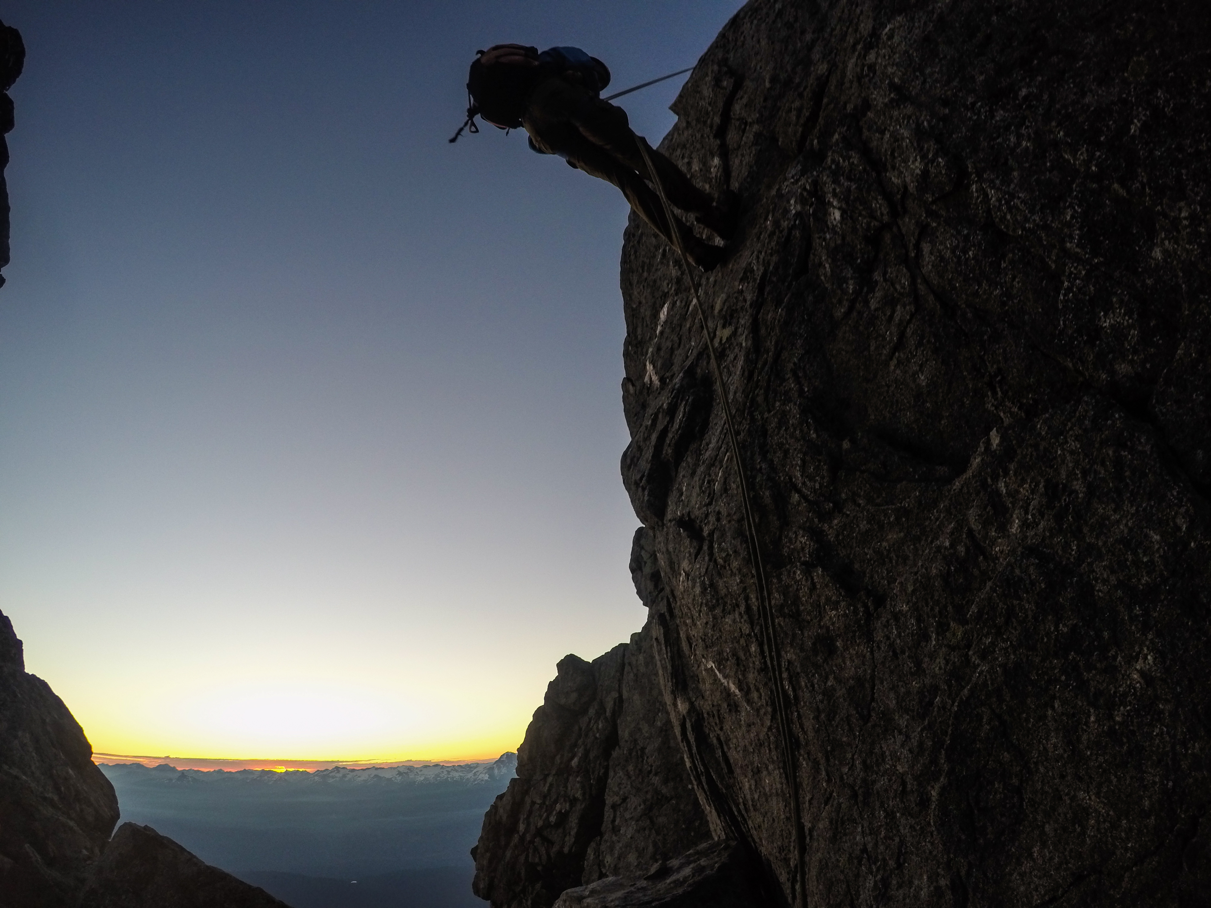
Once we were on the high point of the ridge, the climbing seemed to become a little easier. We climbed over top one of the many gendarmes and found ourselves needing to rappel off. There was a bunch of rap tat slung around this giant boulder. We inspected it and decided to use it. Kevin rappelled off first and then me second. We went to pull the rope and it would not budge. We tried whipping the rope around in different orientations, but whatever we did, the rope wouldn’t move at all. I cursed an innumerable amount of times and after some more pulling, I volunteered to climb back up. The rappel was overhung, so it would have taken ages to prussik back up. I found a way around the gendarme that was a little spicy and totally exposed with hundreds of meters of air below me. Once back at the top, I reoriented the rope and had Kevin test if the rope would pull. This was the lesson we learned. For every rappel, the first person would lower themselves and then test if the rope would pull. If it did, the second person would continue rappelling and all would be good. If it didn’t, the second person would still be on top to put the rope in position so that it could be pulled. I rappelled back down and the rope thankfully pulled.

Kevin rappelling off a gendarme. Photo: Matteo Agnoloni
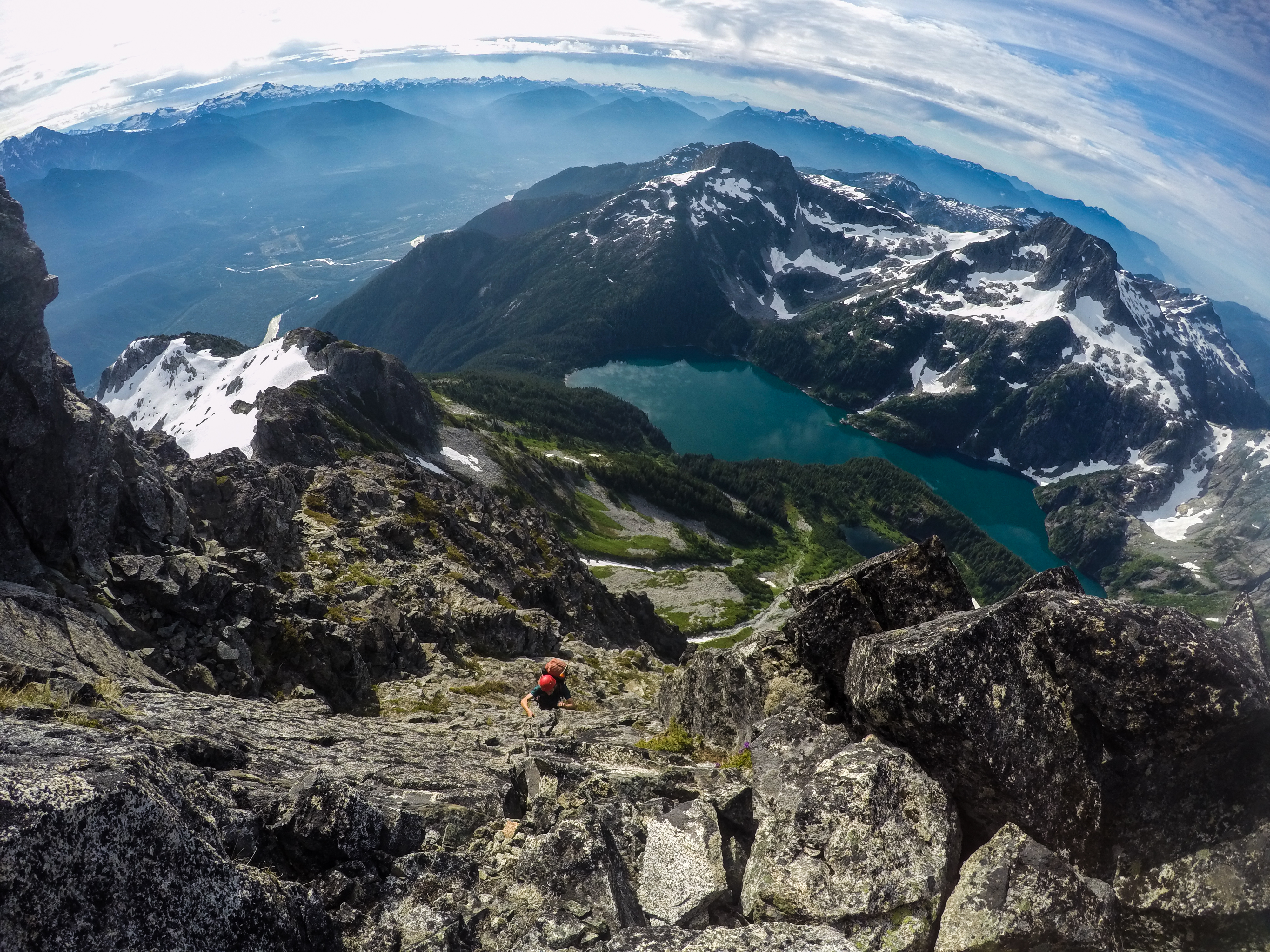
We continued up and over the multitude of gendarmes. Some areas were definitely easier than others, and some areas I was really wishing that we had roped up. I was definitely feeling scared at times, but it was hard to ignore the fact that the terrain really was truly spectacular. Since leaving Lake Lovely Water the previous day, we had not seen one other person on our journey. I had a feeling of being really out there; just a tiny speck in this massive mountain range.
The long east ridge of Serratus with its steep north face on the right. Photo: Matteo Agnoloni
Matteo wishing he was on belay while climbing this airy arete. Photo: Kevin Burton
We finally topped out on the summit of Serratus around 8pm. We had been moving for a solid 16 hours and fatigue was starting to set in. We also only had about an hour and a half of sunlight left. Kevin and I both had the topos for the west face rappel route saved on our phones. It was supposed to be bolted rappel stations straight to the base of Serratus, with an easy 10 minute jaunt over to the Jim Haberl Hut. One of the descriptions we found online said to descend from the summit towards the west face where you will find a cairn. The first set of bolts should be here. We found the cairn, but didn’t see any bolts. We spent the next hour and a half tirelessly looking for these shiny steel bolts, but luck wasn’t on our side. Kevin yelled down to me that we should probably start looking for a place to sleep. We found the flattest spot we could just below the summit of Serratus and I fell asleep feeling very frustrated that we were not able to find the rappel route.
Kevin topping out on the summit of Serratus. Photo: Matteo Agnoloni
Day 3: The Harness That Got Away
I woke up at 4am, had breakfast in bed once again, and tried for the last time to look for the first set of bolts. I told myself I would spend 30 minutes looking and then I would give up. All this did was increase my frustration as I was still not able to find the bolts. I scrambled back up to our sleeping spot to wake Kevin up and told him that we should just start downclimbing the west face. Alpine Select recommends the south face couloir as the descent route, but it was completely melted out and past reports of this descent described the base as being plagued with an impassable bergschrund in late summer.
The first third of the descent was very chossy. We had to take turns downclimbing in order to not dislodge any massive rocks on to each other. We rappelled off this tiny horn that brought us in to this gully feature leading to the west face couloir. From here, we downclimbed the steep snow slope for approximately 30 meters, and then traversed across the snow slope downwards and to the right towards a rocky rib. We carefully downclimbed the rock rib until we were about 15 meters above the snow. If we continued downclimbing to the snow, we would have had to figure out how to cross the two meter wide moat, but we luckily found two solid pitons in a thin crack that we used to rappel on to the snow slope with. Looking back up at the route we had just descended and comparing it with the topo we had saved on our phones, it was hard to comprehend how we did not see any bolts since our descent route and the topo looked extremely similar.
West face bolted descent route. Photo: Altus Mountain Guides
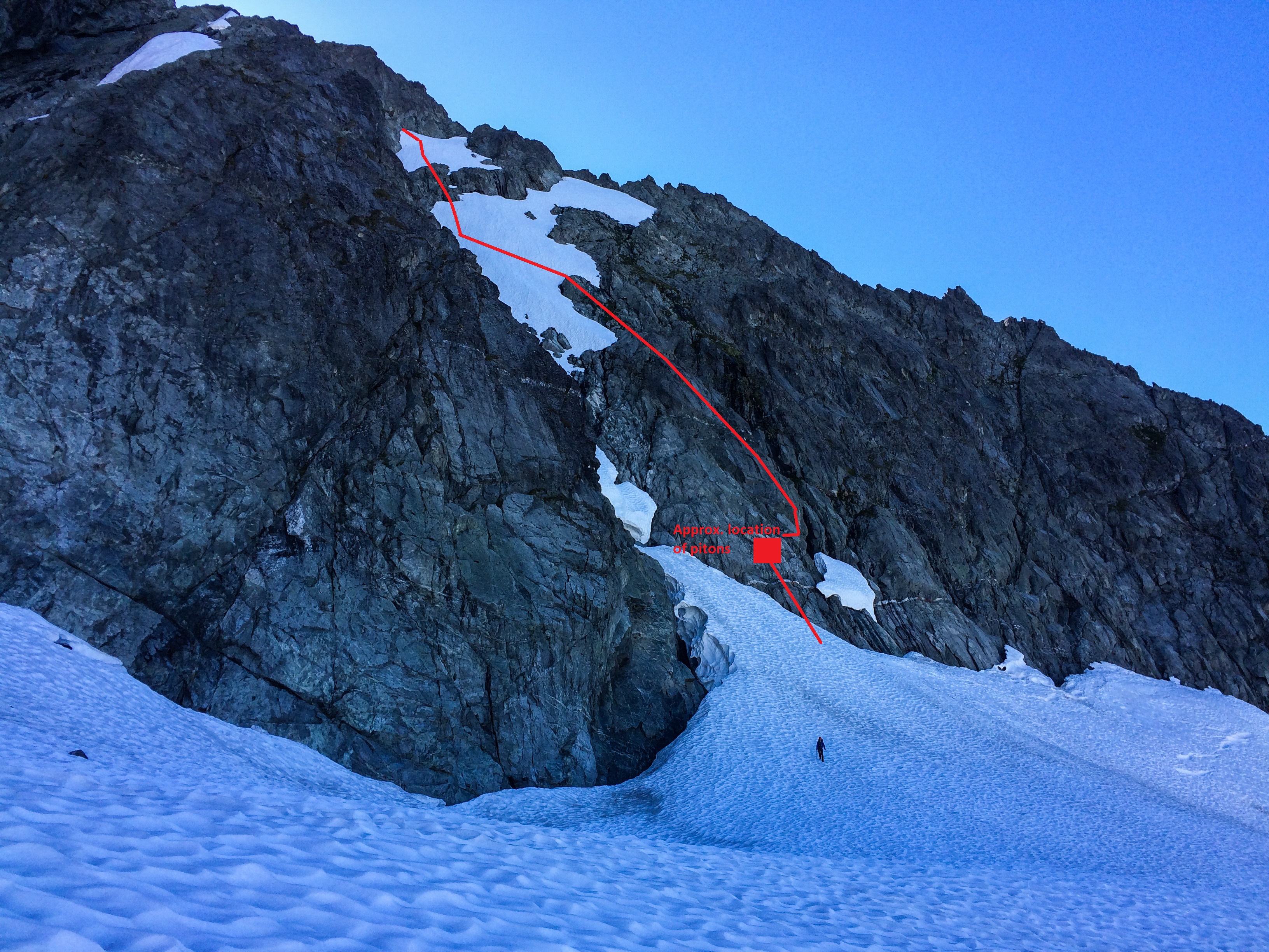
Our approximate descent route. Photo: Matteo Agnoloni
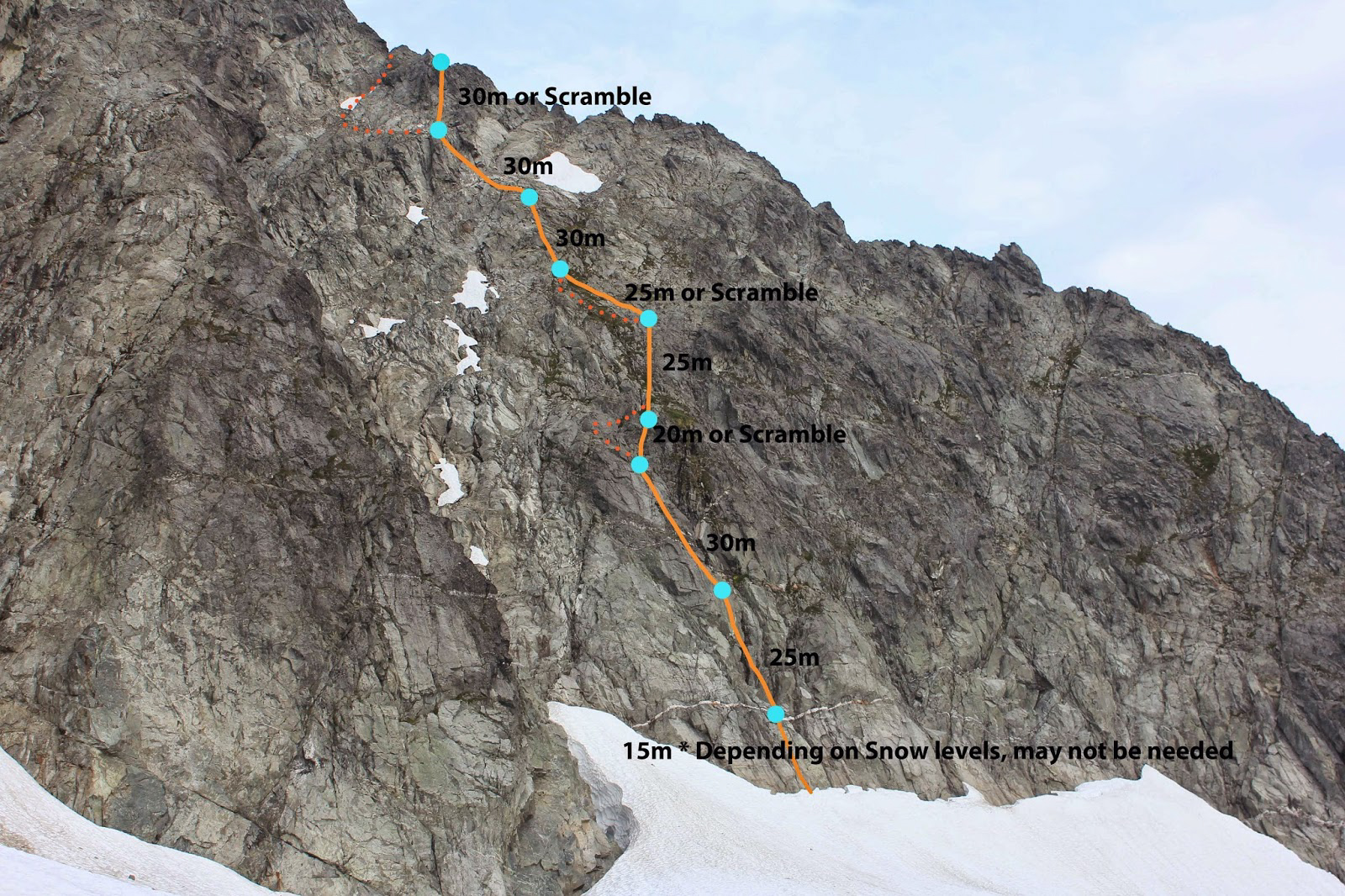
We arrived at the Jim Haberl Hut shortly after and were welcomed by a few of the occupants of the hut. Supposedly, the rocks we hurtled down the west face of Serratus were clearly heard. I also briefly spoke with one of the guides from Altus Mountain Guides who told me that he was one of the people who put in the bolts for the west face descent route off of Serratus. I expressed to him our difficulty with finding the bolts and that we just downclimbed the west face couloir. He told me that our descent used to be the preferred route to downclimb, but in the past years there had been too many close calls with guided groups due to the loose rock. He described that the first set of bolts is very tricky to find, but what you want to do is descend the summit towards the north face of Serratus. Downclimb a short section of the north face, 45 to 50 degree snow, towards a rocky notch. There will be some short-lived 4th class downclimbing until you see a cairn. The bolts should be here. There are six sets of bolt anchors, with the last anchor being a single bolt and a nut. According to him, the anchors are lined up vertically, so once you find the first set, it should be a breeze to locate the rest of them.
We took a short break at the hut to fuel up and use the facilities. It was now 11am. When I was planning the itinerary for this trip, I planned on us getting to the Jim Haberl Hut by the end of the second day, with us departing the hut by 7am on the third day. By these standards, we were only four hours behind schedule.

The Jim Haberl Hut. Photo: Matteo Agnoloni
We left the hut towards Dione and Tantalus, with the plan of going as far as we can and bivvying somewhere on route. The Dione Glacier is quite mellow and wasn’t showing any signs of crevasses or sagging. We travelled unroped across the glacier and only encountered one partially exposed crevasse that we carefully walked around. From the glacier, we gained the ridgeline leading towards the high snow shoulder below Dione. There was a 10 meter notch we would first have to rappel in to in order to gain access to the continuous ridge line. I got there a few minutes before Kevin, so I began to set up our rappel. As Kevin came around the corner, we had a small chat about what our plan was and I asked him if he wanted to rappel down first. The next few words to come out of Kevin’s mouth were words that I had never imagined I would ever hear while on the third day of an alpine climbing excursion. “I think I forgot my fucking harness.” I stood there wide-mouthed. I didn’t believe him. He checked his backpack. Not there. Fuck. I buried my head in the rocks while Kevin continued to yell out expletives. He told me that he vividly remembered leaving it beside the Jim Haberl outhouse, which was about two hours away in the wrong direction. We briefly entertained the idea of him using a sling harness, but that wouldn’t have been wise with the amount of rappels and potential roped pitches we would have to climb on route to Tantalus. Feeling defeated, we retreated back to the hut.
Initially, the first thought I had was that we would have to bail from the enchainment. We could sleep outside the hut tonight and then have a long slog back to Lake Lovely Water the next day. Then I started thinking about how I was starting a full-time job in September, and it would probably be a very long time before I would be able to attempt this enchainment again. I really didn’t want to bail. I then had this naïve thought that if we left the hut at some ungodly hour the next morning, and if we moved extremely efficiently, we would be able to finish the enchainment in one long day. What a stupid fucking thought that was. I somehow convinced Kevin that we should wake up at 1am the next morning and move as fast as we can, as safely as we can, and go as far as we can. Fool proof.
We got back to the hut around 4pm. Kevin’s harness was right where he described he had left it. The habitants of the hut seemed very entertained with our stories of the past few days. We basked in the sun for a while, and then slipped in to our sleeping bags at 6pm to try and get some sleep.
Day 4: The Day That Would Not End
It seemed cruel waking up at 1am, but each day suffering became more and more commonplace. On beginner friendly trips, you tell everyone that suffering is “character building.” Here, suffering was a way of life. I was starting to ration my food at this point. I had only packed food for four days, and we were running low on fuel. We prioritized eating cold food first in order to save fuel for melting water. We joked about eating raw oats and uncooked pasta if it came to it, but we both really hoped it wouldn’t come to it.
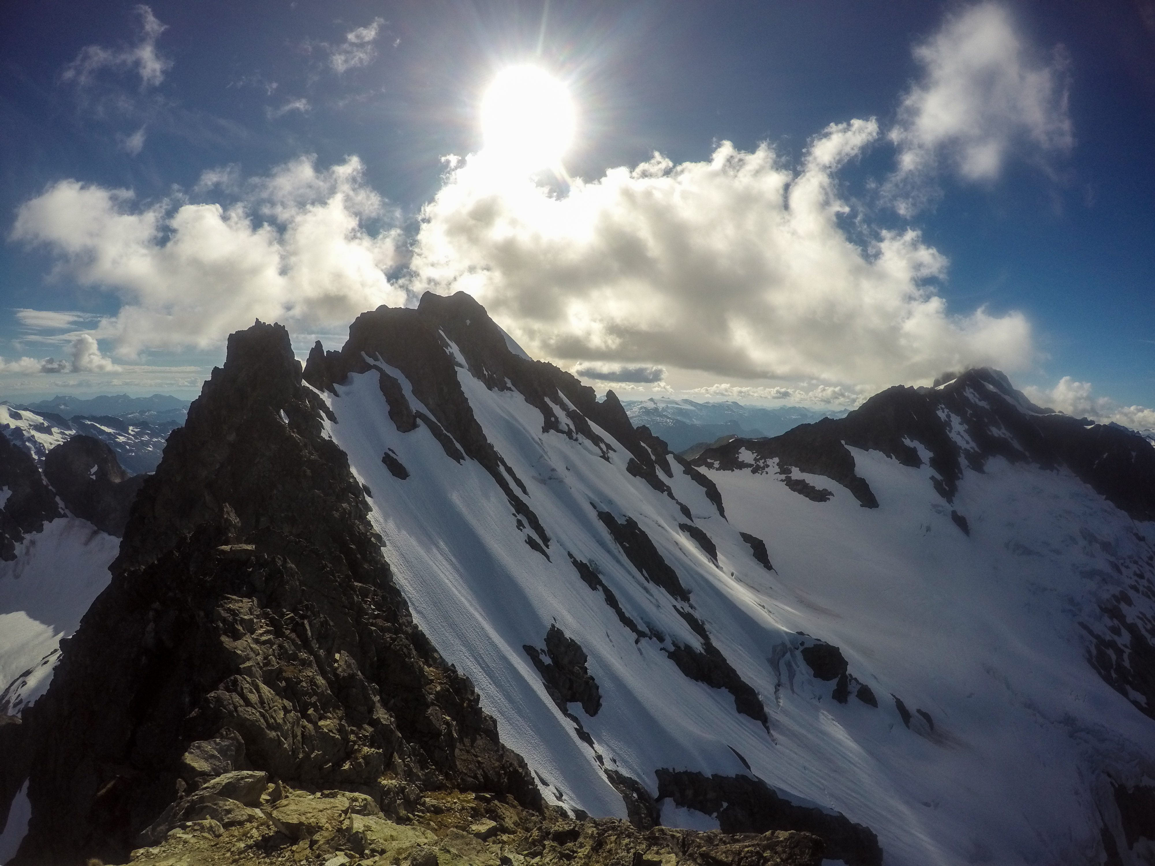
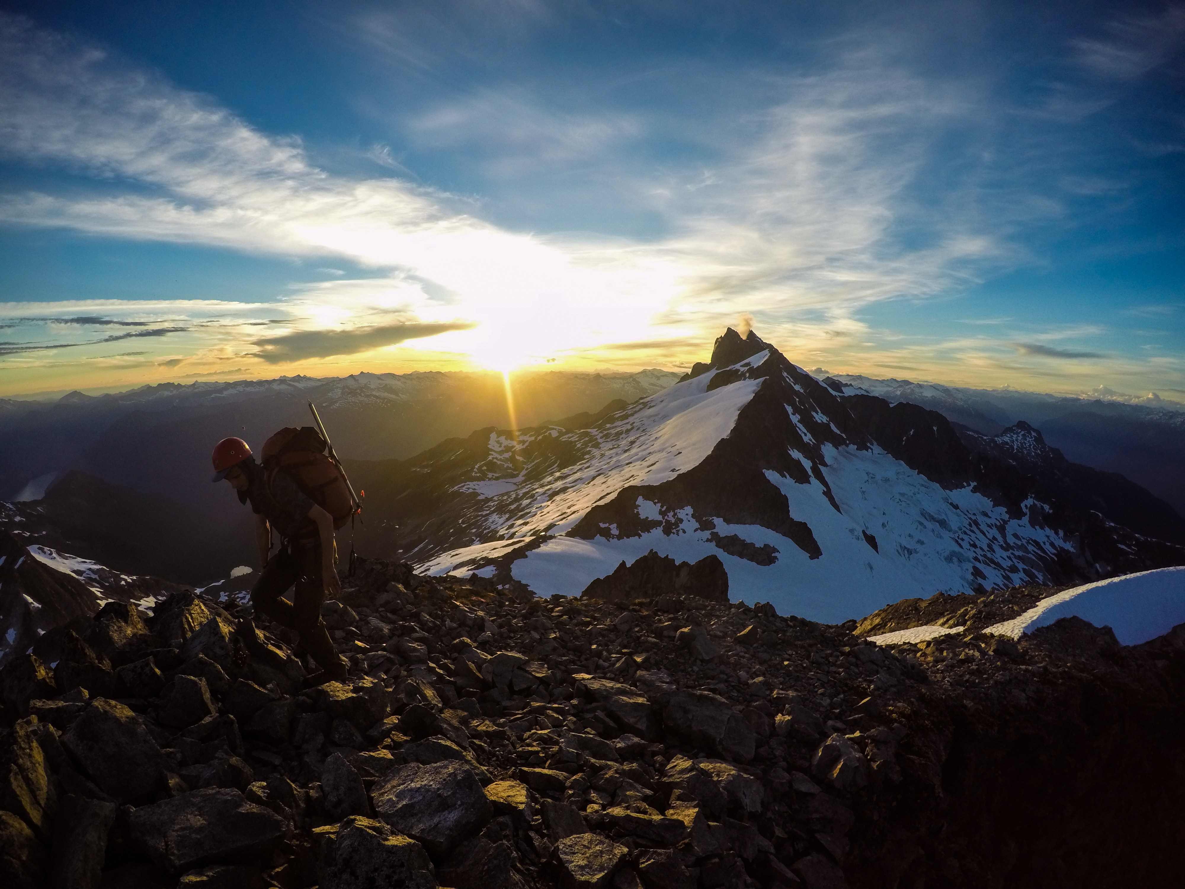
We strapped on crampons and began our third crossing of the Dione Glacier. I asked Kevin if he was wearing his harness. He enthusiastically said yes. The crossing was definitely a slog, but it was hard not to be in awe of the billions of stars streamed across the sky. We reached the ridge leading to Dione, rappelled in to the small notch, and continued up towards the high snow shoulder. As we were scrambling along the exposed ridge, the sun began to rise, giving light to the massive Rumbling Glacier, hundreds of meters below us.
Kevin rappelling a notch in the ridge leading to Dione and Tantalus. Photo: Matteo Agnoloni
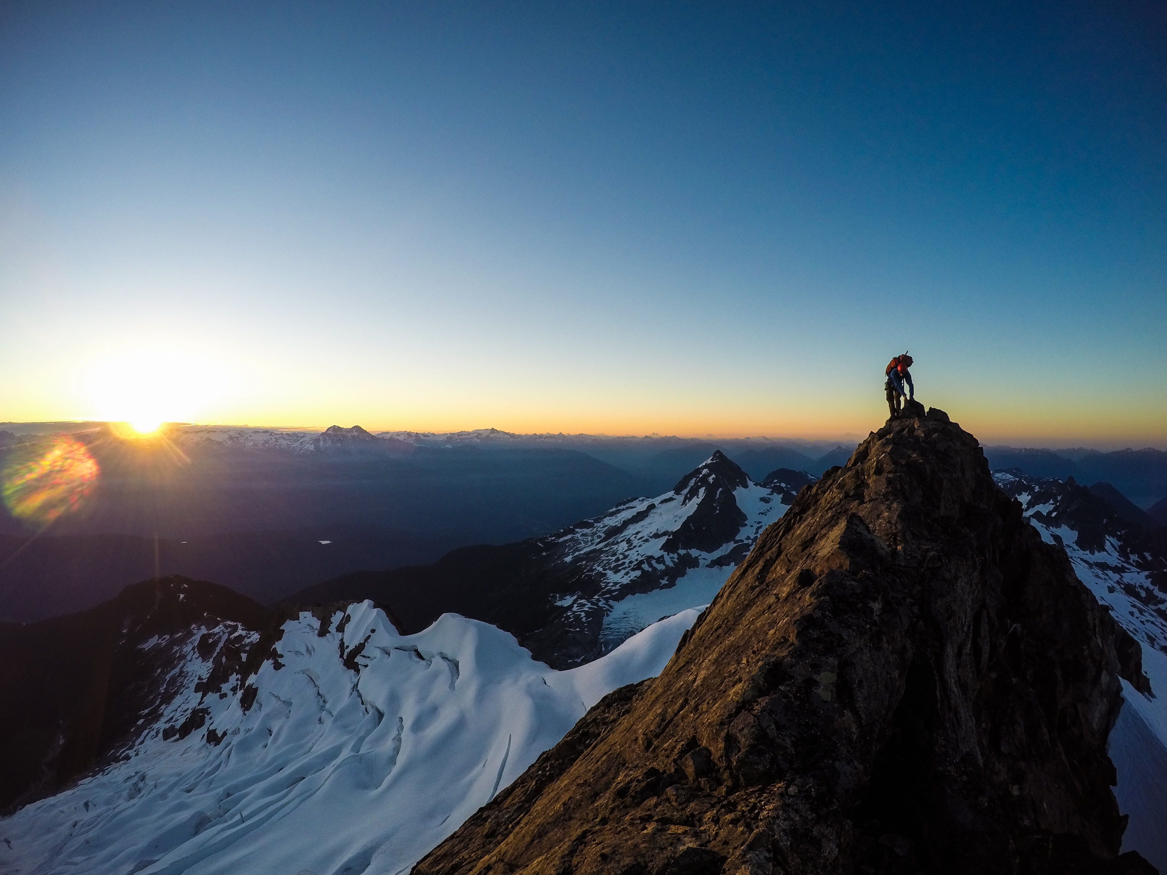
Kevin traversing the exposed ridge leading to Dione and Tantalus. Photo: Matteo Agnoloni
We arrived at the high snow shoulder below Dione with ease. I really wanted to climb Dione, but it did not interest Kevin as much. He decided to stay and melt water while I prepared to climb up Dione. I ditched my pack, tied the rope to my back, and brought a set of nuts and rap-tat. The main difficulty in climbing Dione presented itself in getting on to the actual rock. There was a very large moat with no obvious area to cross. I threw a rock down in to the moat to try and estimate how deep it was. I heard the rock bounce at least ten times before the sound trickled off, confirming my suspicions that if I fell through the moat, I would probably be spat out at the toe of the Rumbling Glacier.

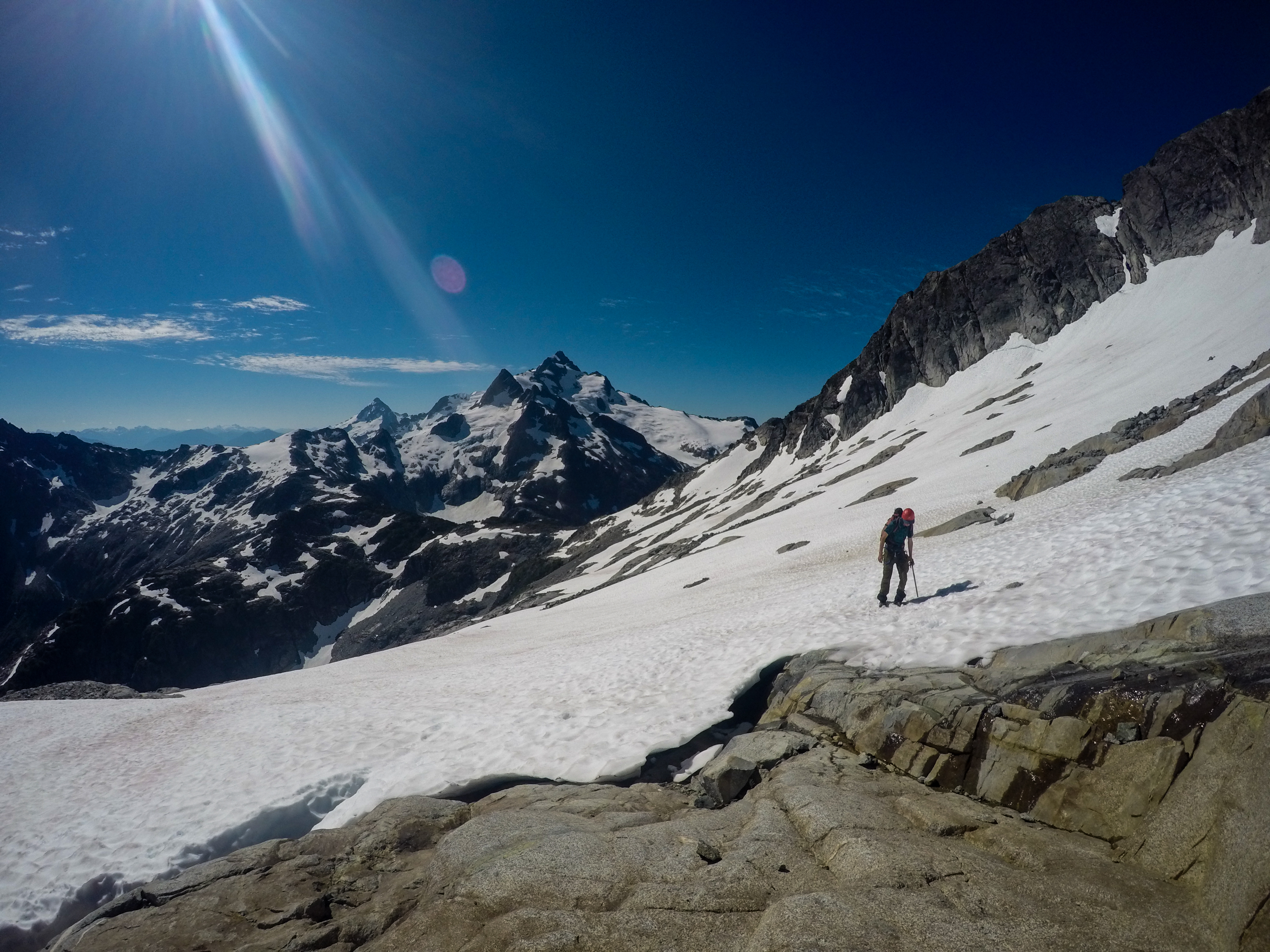
The high snow shoulder below Dione. My line of ascent started just right of the small snow patch. I climbed up and to the left, reaching the top of the snow patch, where I climbed straight up leading to easy terrain. Photo: Matteo Agnoloni
I found a half-decent spot to cross, where the snow was still semi-frozen. I delicately walked across and breathed a sigh of relief when I reached solid rock. I climbed up and did a rising traverse to the left towards a large snow patch. Once at the snow patch, I traversed the edge of it to the left until I reached an obvious gully feature. The climbing looked easy here so I continued straight up. I passed a very established rappel station with five separate slings and a rap-ring. I made mental note of its location so I could use it on my descent. From here the climbing was very easy, mainly 3rd class, and I reached the summit shortly after. I looked at my watch and it had been 15 minutes from the snow shoulder below Dione to the summit. I took some time to catch my breath and enjoy the views, and then carefully retraced my steps for my descent. I rappelled down to the snow patch, and then downclimbed the same way I had come up. I did a second rappel to cross the moat and I was reunited with Kevin. I was super grateful for the water he melted, as we were now both full on water.
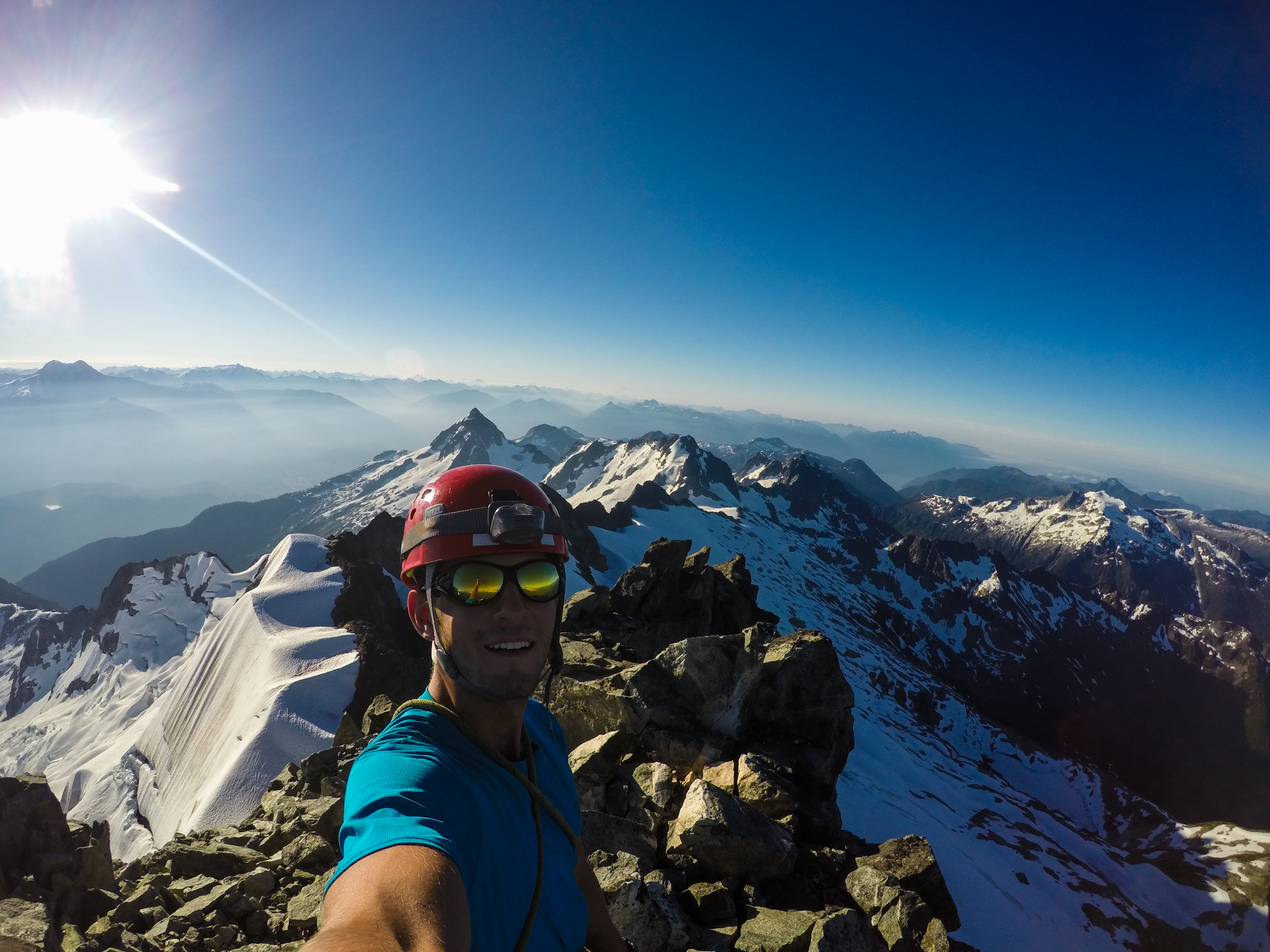
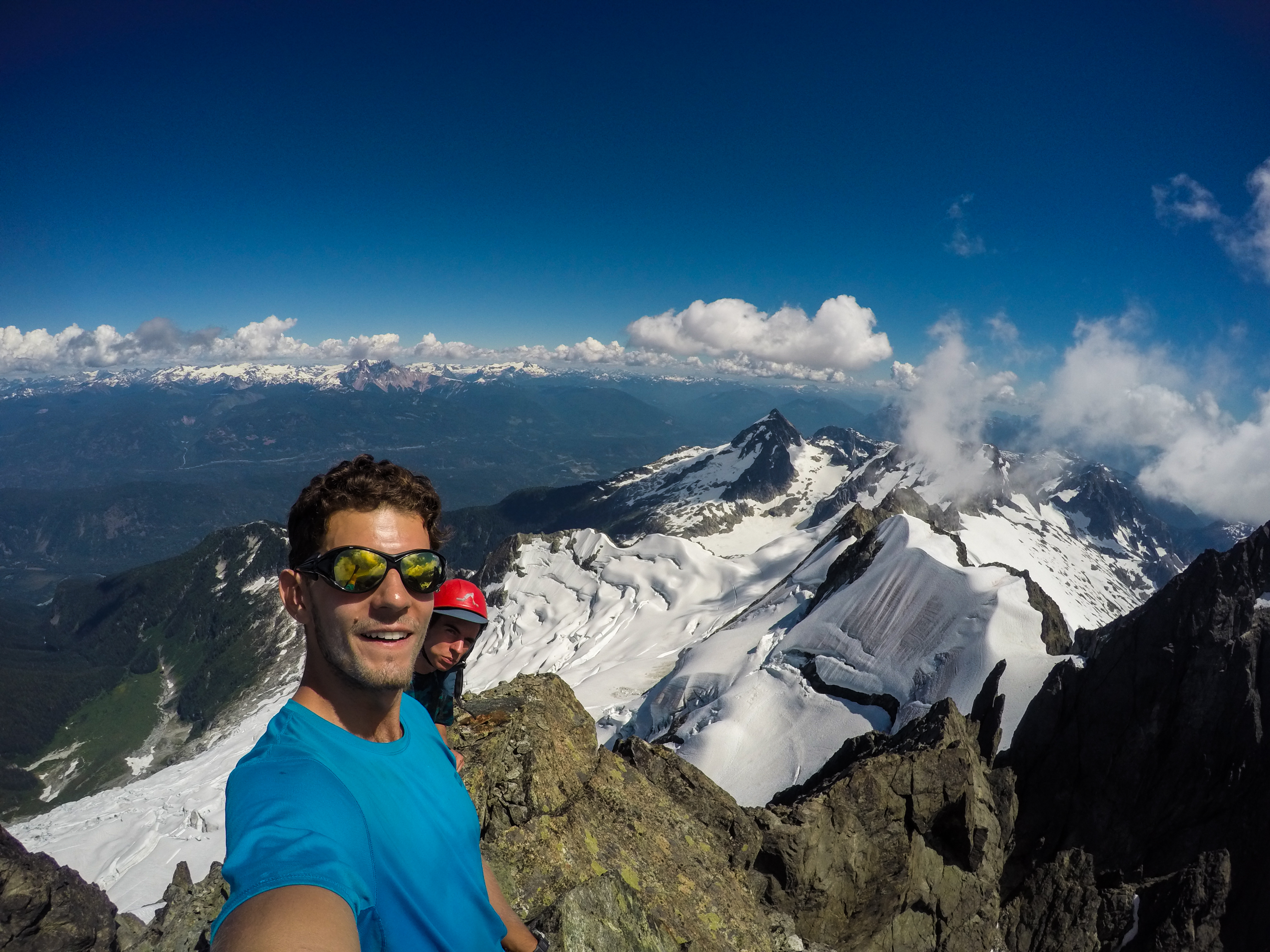
Summit selfie on top of Dione. Photo: Matteo Agnoloni
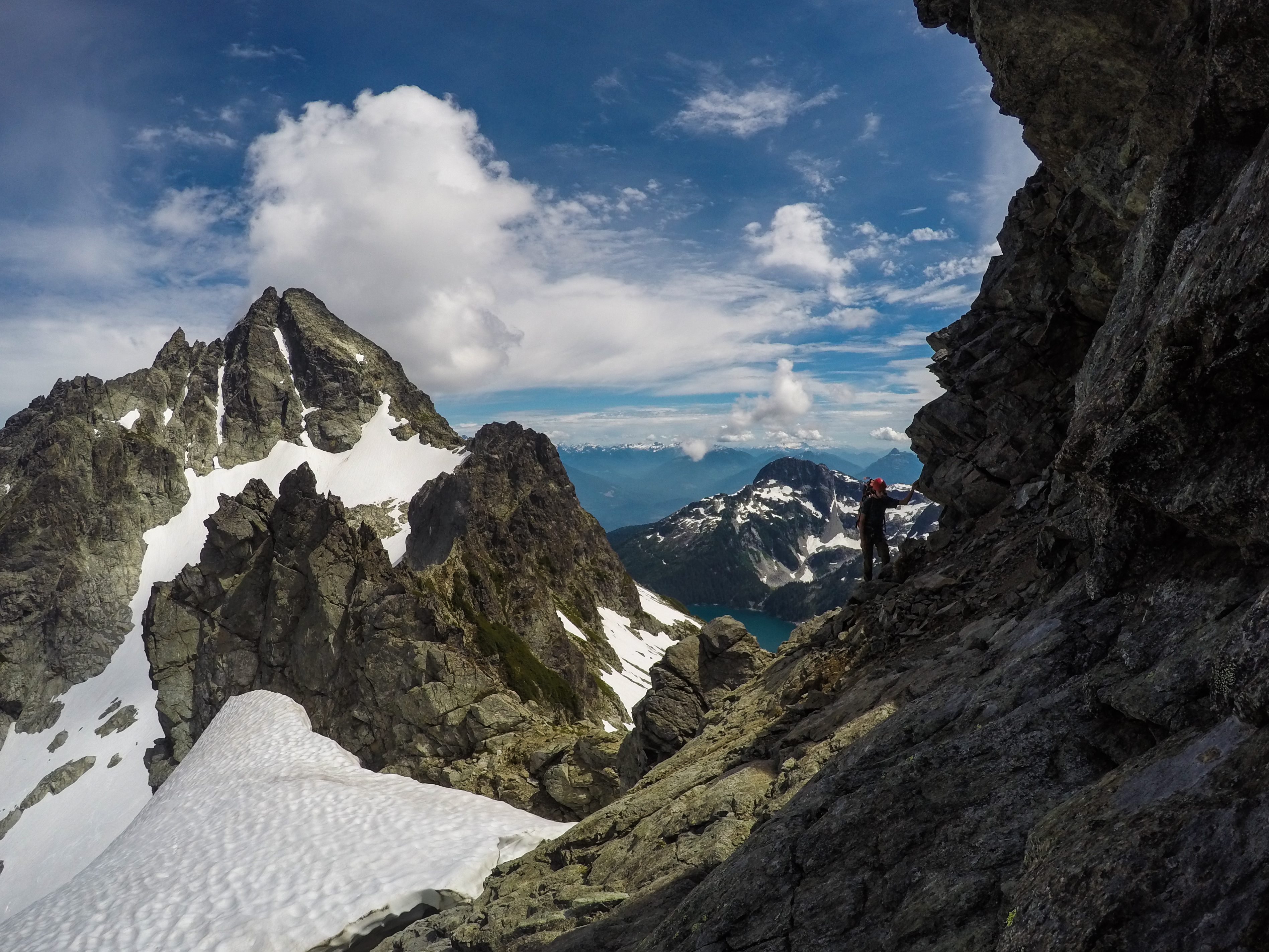
We took some time to mull over the different routes we could possibly take to climb Tantalus. It looked so close, but there was so much complex terrain to get over first. There are two distinguished routes described in Alpine Select. The first is the low route. For this you must downclimb about 100m of steep snow above the Rumbling Glacier, cross a bergschrund to gain access to the rock, climb along ledges towards a large gulley, and then climb 2-3 pitches up the gulley to gain access to easy scrambling to the summit of Tantalus. The second route involves airy climbing towards this prominent gendarme in between Dione and Tantalus, called the Witch’s Tooth. You must then rappel from the Witch’s Tooth down in to the Darling Couloir, ascend the couloir, and then climb the ridge crest towards the summit. The way the low route was described made it seem like the easier option, so we decided to go with it. We began downclimbing the snow slope, and with every step, the extreme exposure became more and more apparent. If you slipped here, you were taking a wild ride thousands of feet down the Rumbling Glacier. As we continued to downclimb, the bergschrund that we had to cross came in to view. It looked impassable. I spotted a sling around a boulder that some parties must have used, but the boulder looked incredibly loose and I didn’t have a good feeling about continuing down this route. I yelled up to Kevin that we should find another way and give the high route a go.
We climbed back up the snow slope and looked for a spot to cross the moat. I spotted a line up the rock that looked climbable, but with a sketchy moat to cross. Sketchy moats and bergschrunds seemed to be a reoccurring theme at this time of the year. I nervously crossed the moat and started making my way up the rock. I found myself in fifth class terrain, edging my mountaineering boots on small footholds, but I spotted a nice ledge five meters above me, so I pushed on. I had wished I was on belay for that pitch, so I set up an anchor and belayed Kevin up. The next section of the climb was an extremely exposed downclimb towards the base of the Witch’s Tooth. We had to climb along a ridge crest and around some large refrigerator blocks. The exposure was immense; on our left was hundreds of meters of fall-line down the west facing Dione Couloir, while on our right was hundreds of meters of air with the impressive Rumbling Glacier creaking below us.
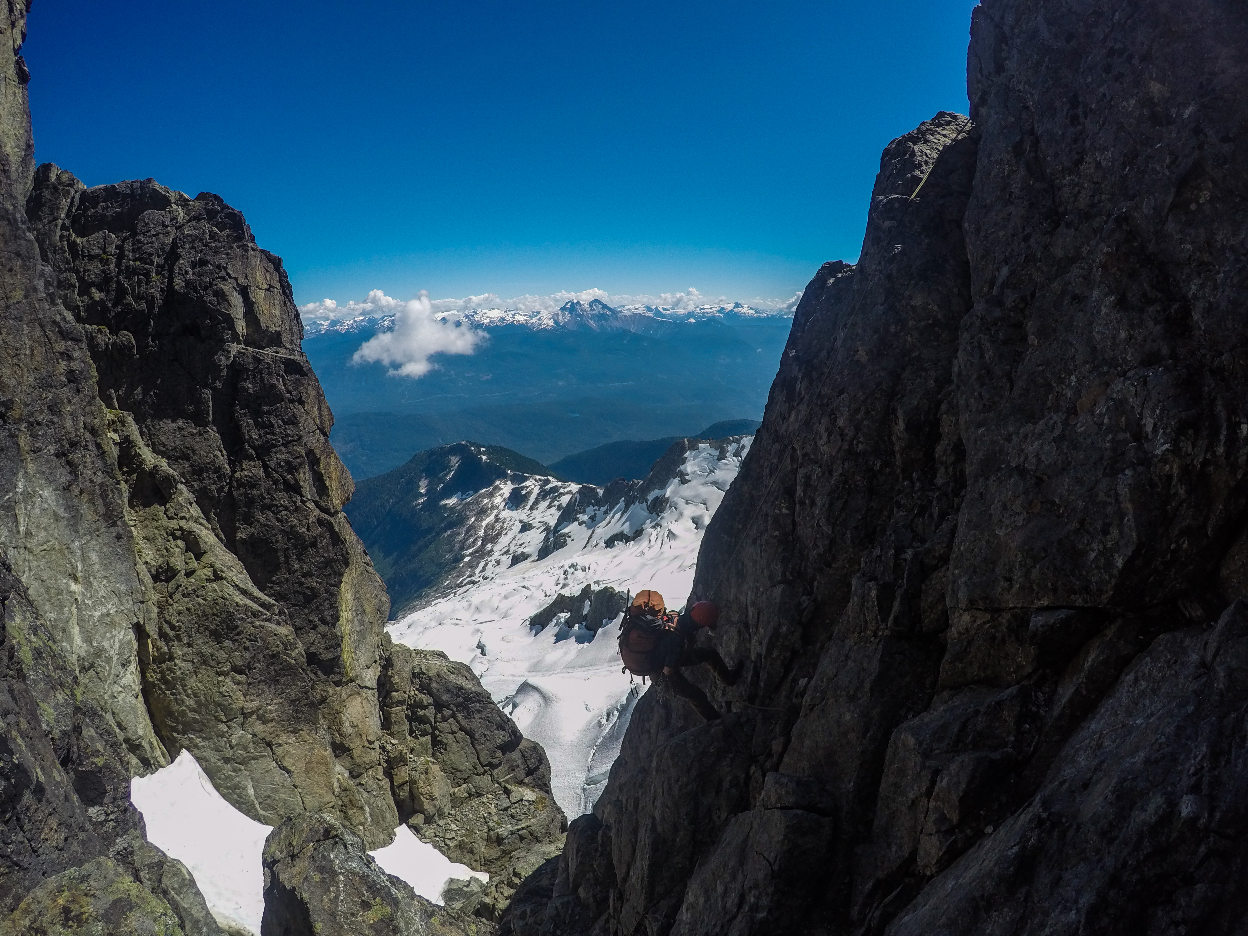
At the base of the Witch’s Tooth, we did a rising traverse towards an old rappel station. This time we pitched it out, as I was getting tired of finding myself in 5th class terrain without a belay. We rappelled in to the Darling Couloir, which was extremely chossy. I started climbing up the couloir and decided to not use a belay. The couloir narrows at the top, so I had to stem up a small portion in order to gain access to a wide hand crack. The crack led diagonally up to the ridge crest where there was some old rap-tat slung around a boulder. I started climbing the crack, but the climbing was becoming harder. “How the fuck is this 4th class?” was something I was getting sick of asking myself. I abandoned the crack and face climbed directly upwards. Once at the ridge crest, I did a scary hand traverse along the ridge with no holds for my feet. I reached the rappel station and belayed Kevin up. We pitched out the next rope length, which was really cool. We climbed under this giant, overhanging block and then scrambled back up to the ridge. This pitch had big exposure, but the climbing was very secure, so we enjoyed it a lot. From here it was easy scrambling to the summit of Tantalus, 12 hours after we had left our bivy outside the Jim Haberl Hut.
Kevin rappelling in to the Darling Couloir. Photo: Matteo Agnoloni
Pitching out an exposed section on route to Tanatlus. Photo: Matteo Agnoloni
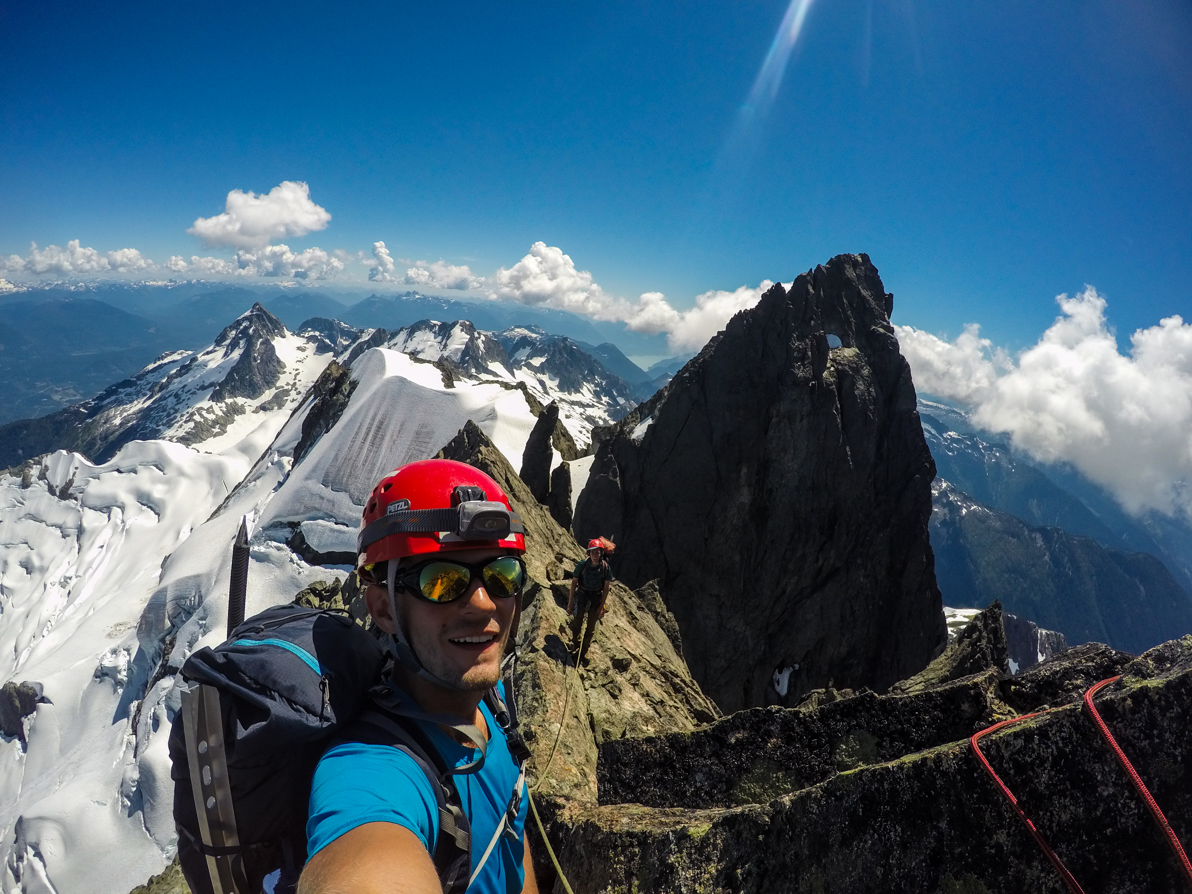
Tantalus summit selfie! Photo: Matteo Agnoloni
Descending Tantalus was much easier than climbing it. Two rappels got us to a snow shoulder on the north side of Tantalus. We traversed the steep snow, rappelled another section of rock, and gained the north ridge of Tantalus. The north ridge was superb 3rd class scrambling. We mainly stayed on the ridge, with only a few sections requiring us to traverse the snow to the west of the ridge. We looked onwards to how far we still had to go. At first, we thought Zenith was Pelion, so it didn’t seem we had to go too far. Then I took a look at my map confirming where Pelion actually was. It was REALLY far and quite disheartening to think that we still had such a large distance to cover. It was obvious we were not going to finish the enchainment today, but we pushed on to cover as much distance as possible.
We reached the last pinnacle of the ridge and started to look for a way to descend down on to the snow. There was no obvious line of descent, so we just slowly worked our way down this rock face. The rock quality was poor, and we were mindful to not release chunks of rock on to each other. By this time it was getting dark, and we maybe had an hour of light. Kevin saw a grassy ledge and recommended that we sleep there that night. I didn’t like the idea of sleeping under a pile of choss, so I urged him to keep moving. We found a rappel station made up of a cam and a nut. I tried getting the cam out but it was overcammed and completely stuck. The nut was also in there pretty good. We rappelled off of this, and then did two more rappels to get on to the snow. By this time it was past 10pm and completely dark. Kevin couldn’t find his headlamp, but I just told him to stay close to me. We ended up finding a flat rock in the middle of the snow field to sleep on. We crawled in to our sleeping bags at 11pm, 22 hours after waking up, and prayed that we would be able to get home the next day.
Day 5: The Long Slog Home
I set my alarm for 4am, but didn’t end up getting out of my sleeping bag until 5am. The cold wind was blowing straight through our bivy spot, giving little motivation to get out of bed. As we were packing up our bags, Kevin accidentally knocked his thermarest off the cliff we were sleeping beside. Just more incentive to get home today. I also only had nine dates and a quarter of a salami stick left for food. We marched on towards the col between Pelion and Zenith. From here, we hiked towards a steep, bushy headwall beneath the south face of Pelion. We bush climbed up the very left side of the headwall, gaining access to the snowy south face of Pelion. From afar, the south face looks quite steep, but is actually quite mellow. We traversed across the south face and up towards an obvious gap on the eastern shoulder of Pelion.
Kevin ascending the south face of Pelion with Tantalus wayyy in the back. Photo: Matteo Agnoloni
This was the only moment where we used the GPS waypoints Kevin had saved on his phone, and we were incredibly grateful for it. Neither of us had hiked the Sigurd Creek Trail, so we had no idea where it was. We descended to the north, hugging skier’s right down the glacier to avoid any crevasses. Once off the snow and glacier, we stumbled our way down the horrible glacial debris. We managed to find trail markers on some boulders, but ended up following the trail markers in the wrong direction, wasting an hour. For those looking to do this, aim for the moraine on skier’s right. If you walk on the crest of the moraine, you will eventually find some orange flagging. When you do, follow the flagging to the right, not left.
Once on the proper trail, I left Kevin and ran down the trail as I still had to bike 20-something kilometers back to my car at the Squamish River. I arrived at the trailhead at 7pm and immediately started biking. I biked for an hour, and then pulled on to the side of the road to take a ten minute nap. I continued for another 20 minutes and finally reached my car. I drove back to the trailhead, took a nap, and awaited Kevin’s return.
When he arrived at the car, we had officially completed the enchainment. Despite being totally exhausted, I was filled with energy from the happiness and excitement of having completed such a massive objective in such an iconic mountain range. We faced many moments of fear and suffering, but we pushed through and completed something big. I had personally pushed my limits in the past five days beyond what I thought I was capable of, and despite wanting it to be all over at times, I find myself wanting to be back in the mountains continuing to push my limits. Although, if you asked me if I would do the entire Tantalus Enchainment by foot again, I would probably say fuck no and cough up the money for a heli-drop.
That’s amazing, you guys are tough.
Yep, wow.
Thanks for not dying, guys!
Phenomenal TR guys, what an adventure! Congrats on persevering, and I’ll echo Roland’s comment about not running into trouble despite lots of adversity.
I’m glad you’re both okay! 9 dates and 0.25 a salami stick was such a disheartening statement to read…serious suffering.
Wowy this was full on
Great TR! 22 hour day… jeez.
What an awesome TR and photos – but more importantly what an awesome trip! Way to push through adversity and get’r done. Glad the risks worked out.
Awesome trip and photo Matteo, way to go!
A memorable TR and I’m sure a significantly more memorable trip. Well done!