Trip Dates: May 8-11, 2024
Trip Participants: Thomas Morrissey, Alex Barth
On May 6th, Thomas Morrissey contacted me that his original partner for a long-planned Misty Icefields traverse had to bail due to emergency circumstances, and that he was now looking for a new partner. I was initially apprehensive about committing to something so involved on such short notice, but it turned out to be too enticing to decline (Thomas’s incessant nagging helped). This left me with approximately 24 hours to plan and pack for a (planned) 5 day trip. Thankfully, Thomas had the beta nailed down, so all I had to do was make a trip to Real Canadian Superstore to acquire 20,000 calories. We were soon headed to Pemberton to make the long drive down the In-SHUCK-ch and Lillooet West FSRs.
For context, the Misty Icefields are a region in the east of Garibaldi Provincial Park, and have a reputation as one of the most remote areas in SWBC. The traditional route involves a water taxi up Pitt Lake to access the south end, and John Baldwin recommends spending several weeks to complete the traverse. However, Thomas had the innovative idea of truncating the traverse slightly, and exiting via the Terrarosa glacier to Sloquet Creek in 4 days. This route hinged on crossing a cliff-ringed lake at the head of the Stave River, located at 999 m elevation. Despite the modest elevation, Thomas assured me that extensive Sentinel Hub research guaranteed that the lake would be frozen until late May. This greatly simplified the logistics, but we still had to shuttle 50 km of logging road between the starting and ending points. Thomas, being both a miser and an absolute beast, volunteered to ride my mountain bike across this distance in the middle of the night instead of driving a second vehicle. This took a bit longer than expected, and he eventually joined me at the tent on Chief Paul FSR at 4am, when I had already been sleeping for 6 hours.
The terrain on the approach ridge just after breaching treeline
Needless to say, we got a bit of a late start on the first morning. The access to the Misty from the north, while much simpler than from the south, involves traversing a rolling subalpine ridge that seems to go on forever. After many hours of forest slogging, ups and downs, and brutal heat, the views began to open up as we approached the ascent of the Icemantle Glacier group of peaks. It was already late afternoon, but the alpine views gave us a second wind and we managed to reach the summit of Greenmantle Mountain around 7pm and set up camp just down the ridge. We had paid the price of admission and were now entering the meat of the traverse.
Sunset from just below Greenmantle Mountain, with Mount Pitt at center left
The objective for the morning of day 2 was an intimidating one: Mount Pitt, the tallest peak in the area. It involves a substantial amount of out-and-back from the regular traverse route, and some moderately technical terrain. After being forced to descend almost all the way to Snowcap Lakes, we transitioned to ascend Rollercoaster Ridge. From the name, you can probably guess what we were in for. Each bump we went up and over got progressively steeper, and the heat wave had stopped any real refreeze from occurring. I watched Thomas cut some ridiculous switchbacks with constant sloughing, and decided the conditions were likely to deteriorate throughout the day and with many hours of steep terrain ahead of us, we aborted the attempt. Although we had missed out on the biggest peakbagging objective, we were now set up very well to finish the rest of the traverse.
Snowcap Lakes from Rollercoaster Ridge
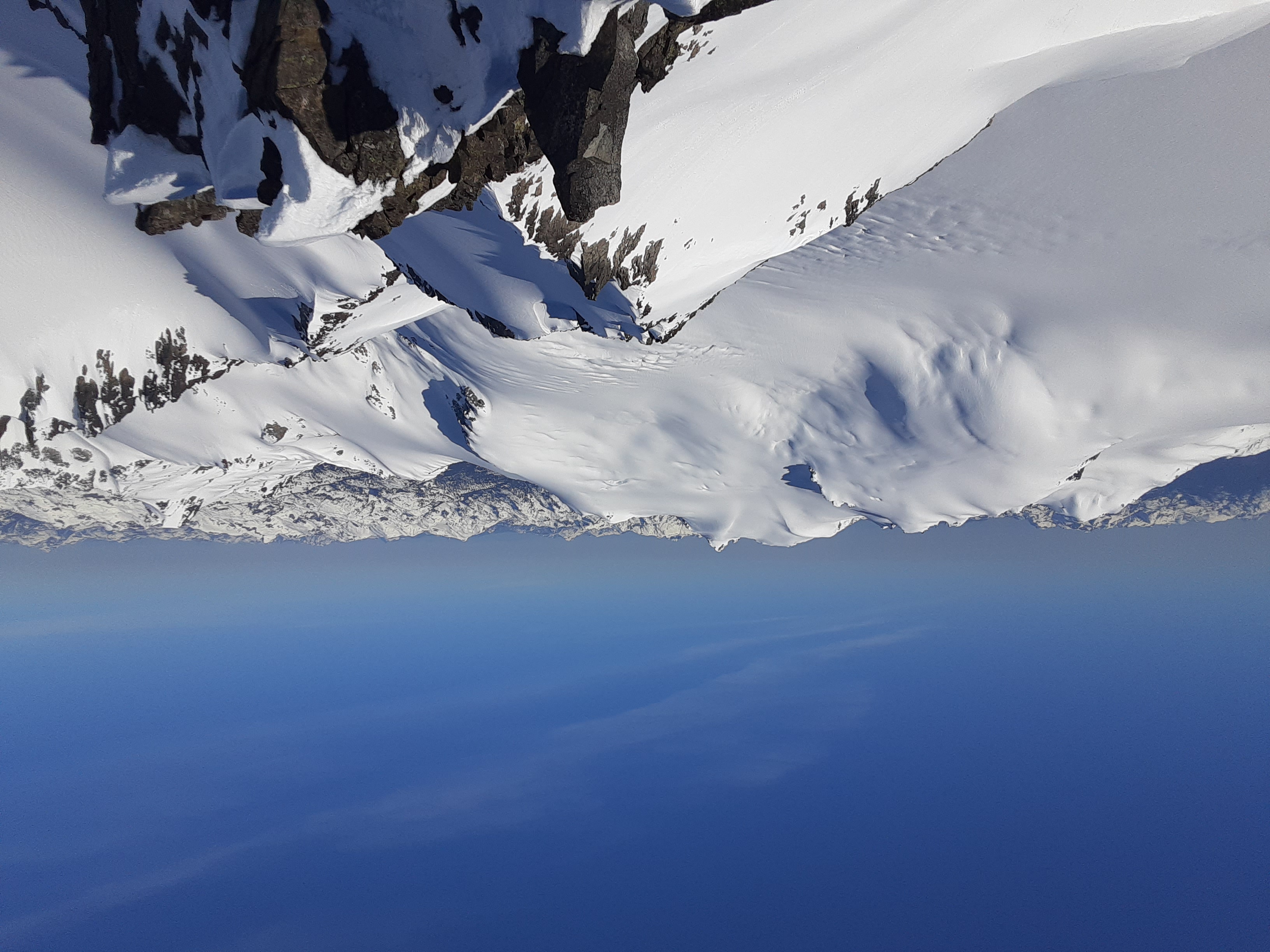
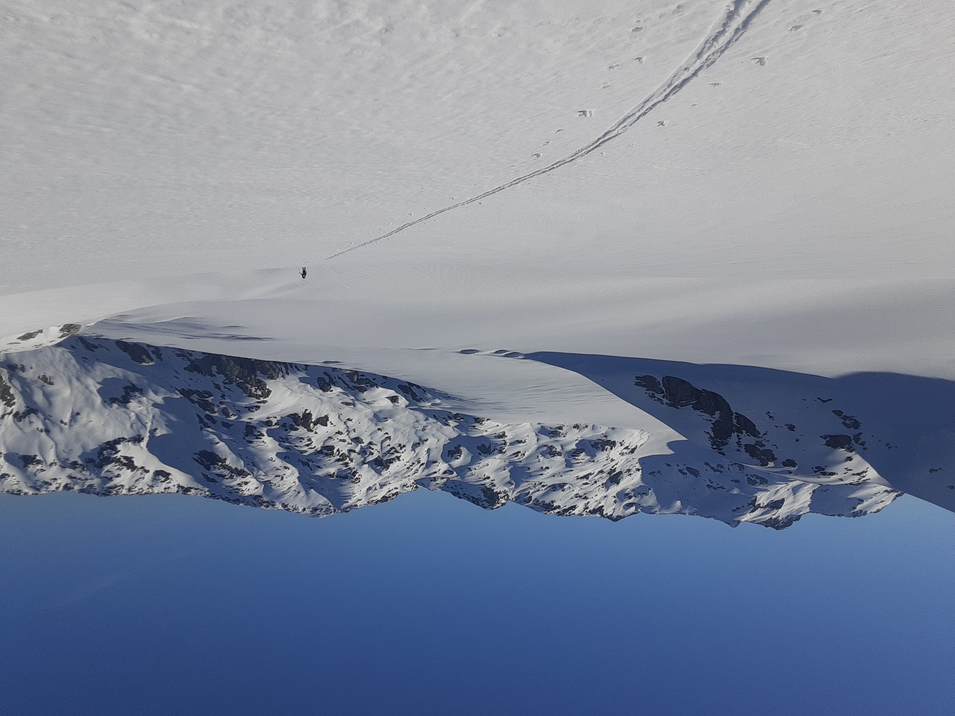
We reversed our tracks to Snowcap Lakes, which is a beautiful spot and well worth spending more time at, but we were traversing and couldn’t afford more than a short break. Ahead of us was the start of the real Misty Icefields, a long climb up to the glacial plateau of Snowcap Peak. The narrow summit offered maybe my favorite view in the Coast Mountains, with the McBride Range dominating to the north, the impressive east sides of Mamquam, Nch’Kay, and Castle Towers to the west, and several craggy peaks to the south and east. It was a privilege to experience such a unique and rare position. Skiing down the south side of the massif I was impressed by how glaciated it was given the elevation and aspect. This area receives enormous snowfall and the glaciers are massive. We had now reached the heart of the traverse, the Misty Icefield itself. This glacier terminates in a massive lobe that is impressively flat. We spent several hours of foreshortened slogging until making camp higher on the glacier.
The summit of Snowcap Peak
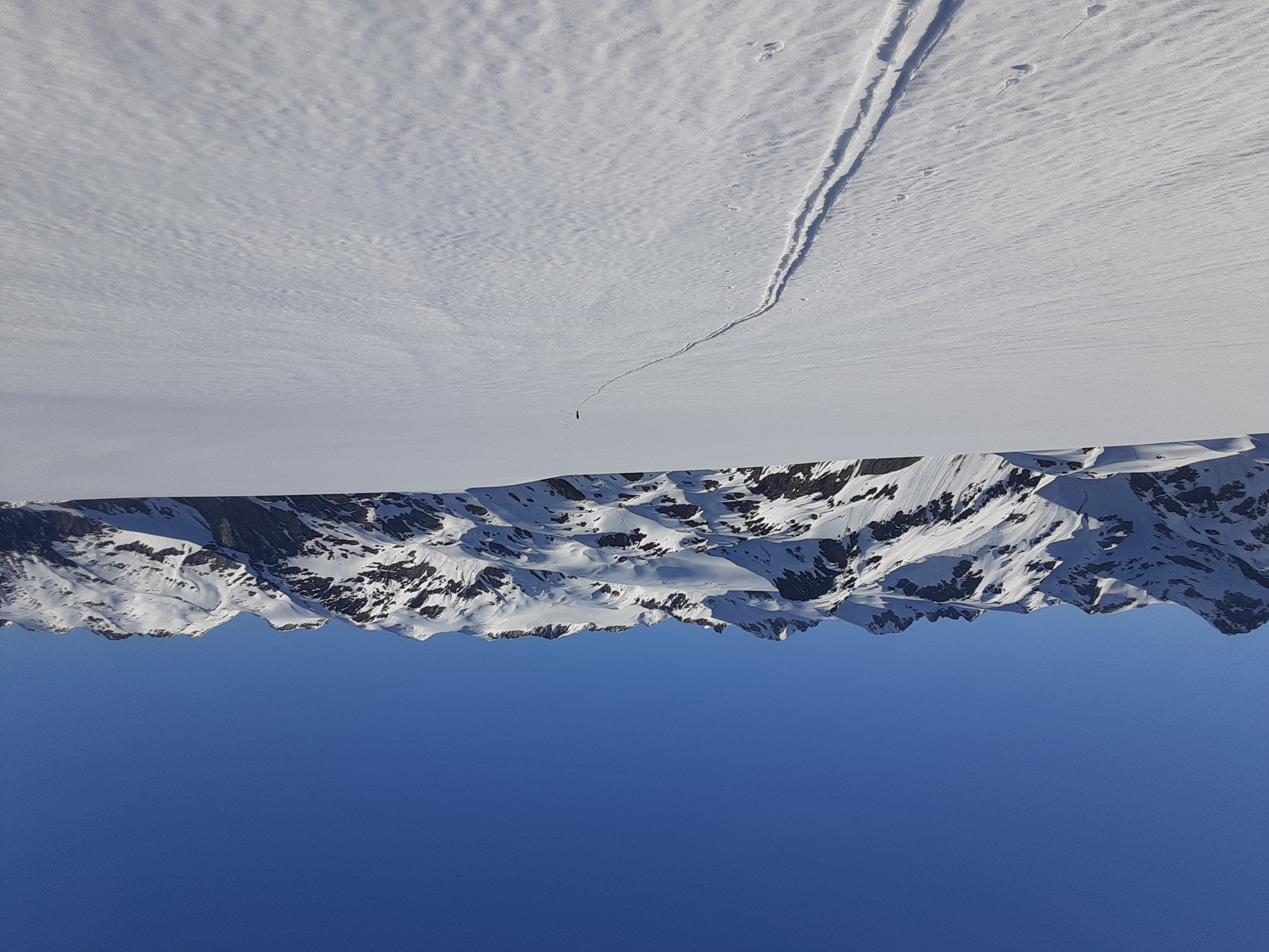
The Misty Icefield stretches on
On the morning of day 3, the snow had firmed up nicely, and we made a quick ascent of Stave Peak before skiing down to the last major icefield, the Stave Glacier. At this point we were well ahead of schedule, so we dropped packs to do some peakbagging. First we went for Katzie, and I let Thomas go ahead since I was dragging and didn’t like the look of the steep summit pinnacle in the conditions. Thomas found an acceptable route up and we met back up to summit Nebula Peak, a pleasant ski. We were then ready to make the long ski down the Stave to the lake, which we would cross the next morning when it was most frozen. This portion of the trip involved the most complex glacier navigation, but we easily skirted the first icefall. At the top of the final icefall at the toe, we got a good look down the valley and it looked disappointingly dry. We couldn’t see the critical lake, but a smaller lake upstream of it was totally thawed. It looked like we were screwed. Fortunately, Thomas had a backup route in place (that we had discussed beforehand). It relied on recent SWBC peakbaggers beta on the route up Sloquet Peak, enabled by recent logging. Unfortunately, to access Sloquet Peak we would have to cross the Stave River, but Thomas was confident it would go. We turned around and slogged back up the glacier, cutting our losses. A side bonus of this route change was that we got to summit Corbold Peak, famously the only summit achieved by the Roland Burton et. al. party that was first to do the traverse in 1972. From there we skied down to a camp at Pukulkul Lakes, surrounded by rugged and steep walls.
Katzie Peak is the small pinnacle
Climbing up from the Stave Glacier
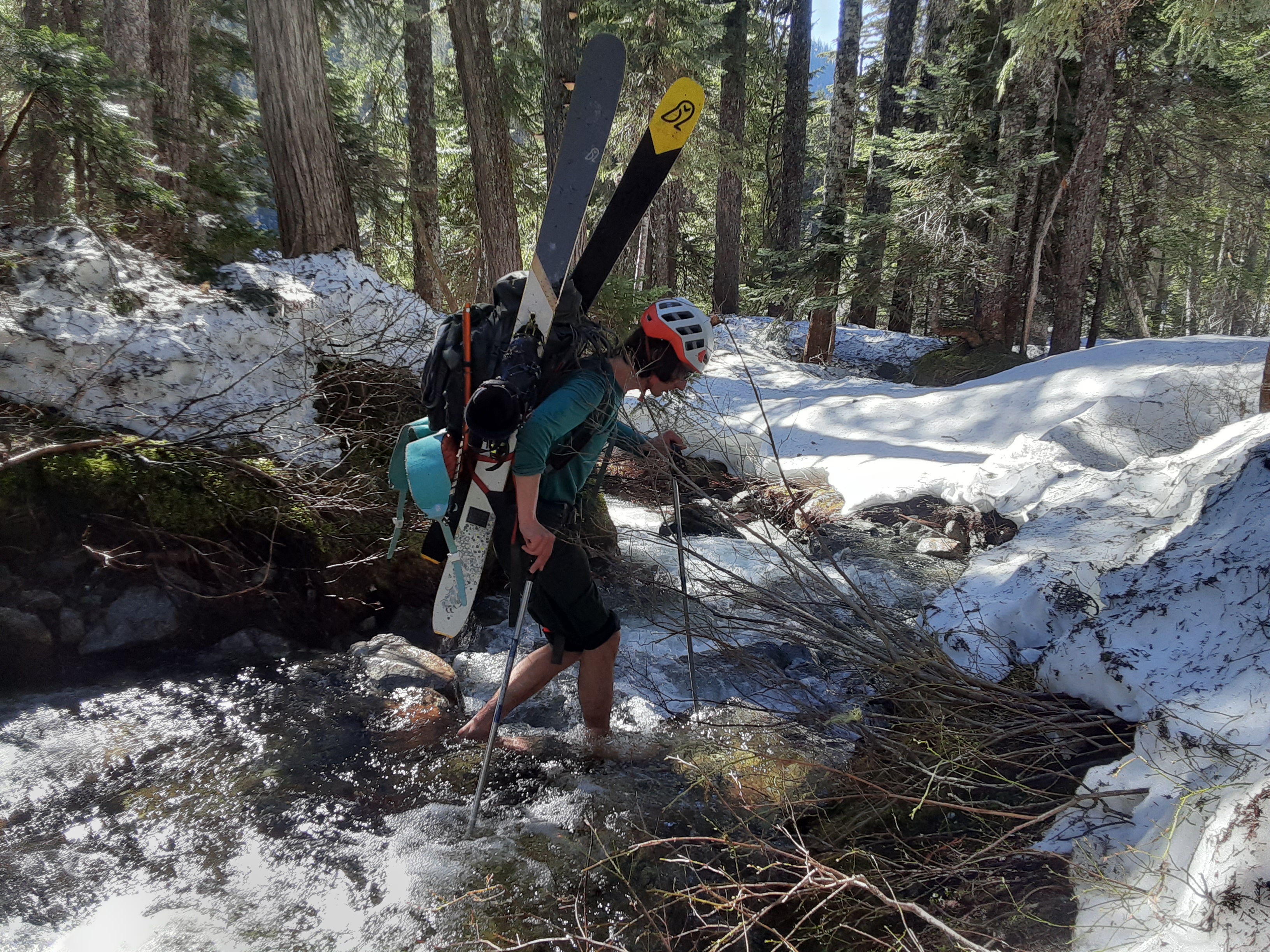
The next morning, we made a short climb to another lake from where we would descend to the Stave River by a creek that Thomas identified as being low-angle on the map. This proved to be pleasant with nice trees and good snow coverage all the way. We reached the river a bit too far upstream where it was still a canyon, and had to do a few barefoot creek crossings to follow it down to a spot where it looked safe to swim. This is where the debacle began. The river was nowhere near fordable, so we would have to set up our rope to ferry loads across. Thomas swam across with the loose end to rig it up at a 45 degree angle to work with the current. Unfortunately, he then realized he couldn’t get back. With poor communication, I had to pack his pack for him and ferry across with both. Despite our 5-to-1 tensioned static line, the rope still sagged enough to completely submerge our packs, which were not packed with this in mind. Upon the other side Thomas swam back to retrieve the rope, and then we assessed the damage. Fortunately we had a rocky beach in the sun to dry gear, but unfortunately neither of our phones would turn on and we had no paper maps. At this point though we just had to go up and over one pass and Thomas had a good memory of the line. We spent a few hours drying out then started up the drainage on the back of Sloquet. The creek eventually became a canyon and we were forced up and left until we were well above the creek. With no maps, there was some worry that we would be cliffed out and unable to descend to the pass. However, eventually the cliffs mellowed out and it turned out we had probably taken the optimal route anyway. We had reached the pass in good time and were excited by the prospect of reaching the hot springs that night instead of camping out again. We had now rejoined the established Sloquet Peak route and followed the hard traverse to reach the logging road. On this descent my toe started to hurt quite a bit, and when I took my boots off to cross a creek it was dark purple. I later learned that it was minorly broken, probably in the river crossing. Fortunately once we reached the driveable end Thomas, ever the hero, volunteered to run the 8 km to the Glendinning TH where the car was parked and come back to retrieve me. We made it to a horrendously crowded Sloquet Hot Springs past 10pm, and barely found a spot to camp. This was a stark contrast to our previous 4 days of solitude but the soak was worth it. The next morning came and all we had to do to get our disheveled selves home was drive 100 km of logging road to Pemberton and then all the way back to Vancouver.
This was just the beginning…
After this trip, I learned that a spectacular aurora had been visible in SWBC during our trip. We never saw it, as we slept from 9pm-5am every night and never went outside in the dark. It would have been quite the sight had we known about it, but that’s the reality of ski traverses in this style and I’ll take the trade off.
Lessons learned:
-You don’t have to be super fit to cover a lot of ground, you just have to keep moving. I wouldn’t have thought myself in the best shape coming into this trip, having spent most of a year recovering from knee surgery. I thought I’d need 5 days to do this trip, but with 12 hours to move the meters added up and it went easily in 4 even with side trips.
-The Misty Icefield might be a bit more approachable than you think. We have certainly not solved the access problem, as the lake route would need to be done in April and the Sloquet Peak route, while it involves less elevation gain and easier bushwacking, is untenable due to the river crossing, but it was overall easier and shorter than I would have expected from the reputation. In addition, some recent research revealed a ridge route to Fire Lake that may be the golden ticket for those seeking to avoid Pitt Lake. The area is spectacular and highly recommended.
-Wear your shoes on serious river crossings, they’ll get wet anyway so you might as well protect your feet. Also, if you come unprepared with no ziplocs or drybags, put your phone in the middle of your compressed sleeping bag, it was the only thing in my pack that stayed dry.
-Old school navigation backups are maybe not a bad idea on longer, more committing trips
-Checking the satellite after, the lake was indeed showing blue around the edges, so we probably made the right call. On the last clear imagery 9 days before it looked solid but that was probably too long ago to rely on.
-Approximate stats: 80km, 6000m
Thanks Alex, reading this brought back some vivid memories: good ones like camping on Greenmantle and standing on Snowcap; bad ones like sunburning my hands/lips, sous vide-ing my feet with ski boot sweat, and of course botching the river crossing. I also see that none of my “Take the Misty” song lyrics made it into the TR, which is probably for the best.
I considered appending the song haha, but I figured I’d leave that up to you
Super cool trip, beautiful views with some healthy character building on the way out… hope to do something similar one day. Would caution against calling the start of Glendinning a “trailhead” but that’s just me haha. I wonder if traversing from the Misty Icefield to Terrarosa Glacier and down the Glendinning/ Fire Spires route makes it any easier? Great TR!
Definitely go for it (or any other traverse) if you get a chance! Yeah that was our original plan. We were well aware of your experience on Glendinning and Thomas had been there before. The words of encouragement once we knew we would have to go the Sloquet way was that at least there would be much less bushwacking then Glendinning. I think the river crossing is bad enough to make it worse overall though, at least the way we managed it. I think following the subalpine ridge north from Terrarosa Lake to Fire Lake could be an interesting alternative, I spotted it on the map and then found a vague online comment from someone saying they had done it. We also now think you could get around the bad lake via the ridge dropping east from Stave Peak but then you’d have to out and back the Stave Glacier (not to be missed). If you can swing the water taxi the Pitt Lake version is probably the best experience since you get the extra terrain to the south.
Epic stuff!
Good read and quality traverse, Mount Pitt looks like it might be a fun one to add to my list..