Sunny and warm on Saturday, foggy/cloudy and wet on Sunday. Not bad for coastal BC weather in October!
One of the cars (a Jetta) did not have enough clearance to make it all the way to the trail head, so car pooling was required for the last Km or so. Kudos to Crisel for making it that far away.
However, on the way up we were dusted by a Toyota Echo going up strong with a crew of 3. Who needs a 4WD! Kudos to them as well!
No dangerous wildlife encountered during the trip… only apes with axes and spikes under their feet!
Long walk on the forest service road followed by a steep ascent.
Some trail marks guided us to the west side of the creek on a not maintained trail.
At about 2/3rd of the final ascent we lost visual of the trail marks.
We attempted to cross the creek but were not able to see signs of trail markers; the terrain got steeper and we decided to cross back and continue on the west side of the creek. Sketchy final ascent on slopes that might have required to rope up. We did not. No margin of error.
Saturday PM and Sunday AM were spent on the glacier for the usual drills.
On the way to the glacier be careful walking on the rocks since many are not stable and wobble a lot! This is the proof that the glacier is alive and keep pushing, cracking and moving the rocks!
Unfortunately there was not enough snow to slide and practice self arrest with axe. So Lucy, Richard and Alberto had to pull us down. However, we found several crevasses to practice rescue techniques.
Sadly the glacier was covered by black dust (perhaps from the wildfires ashes) which would accelerate the melting.
Stunning hole and ice cave (credits to Crisel Brako):
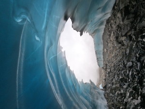
The cave is on the extreme west side of the glacier
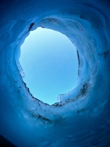
The hole is right at the midway of the glacier at the front.
DANGER: it should be obvious but stay way back from the edges!!
On the way down we decided to follow the trail on the east side of the creek and found it easier and doable.
Lesson learned:
- even if someone else has a gps bring your own with the trail tracks and consult it… often!
- stick to the east side of the creek especially if your bag-pack weights 15kg and you have to carry another 8 Kg of 60m wet rope from the VOC gear rental.
- once you commit to one side of the creek it is hard to switch because of the steep slopes of the last vertical 300m.
- don’t count the number of ditches you are going to cross along the forest service road on your way back; don’t tell yourself “this is it, this is the last one!” … they simply never end! Just walk and chat with your new friends about what a great experience the glacier school has been… or simply continue practicing your knots!
Many thanks to Lucy, Alberto and Richard for teaching and organizing this trip.
GPS route can be found here https://ridewithgps.com/trips/57628661