In March, before skiing became controversial, Alex R., Dave M., and I did the Wedgemount-Currie traverse. Birgit was supposed to come, but she got a second cold immediately after recovering from the cold she had the week before. It was an excellent trip with one exception, which is what this trip report is about.
Late on the second day of the trip I—or I and Dave, it’s a bit unclear—triggered a size 2 avalanche on a very hard snow surface that wasn’t obviously softened by the sun (we skied out of it and no one was hurt). I’m writing this up in case people are interested in what we learned about hard slab avalanches, although I am mostly relaying info from Avalanche Canada and from Bruce Jamieson’s videos, because I myself have no expert knowledge here.
The avalanche happened when we were traversing a short SW slope in the bowl S of Mt Currie (see annotated photo). When we started across the slope, we couldn’t see that there was some old debris below at the base of an adjacent slope. Dave was ahead, and when I saw Alex behind I started off. I punched the slope with my pole was confident the surface was too hard to be a problem. My weight, or possibly the combined weight of myself and Dave (who was nearly off the slope), caused a slight cracking sound, and then a loud bang, and then blocks started coming down from above because the avalanche had propagated well above us. The crown line was around 35 cm, and the slope angle was around 35 degrees.
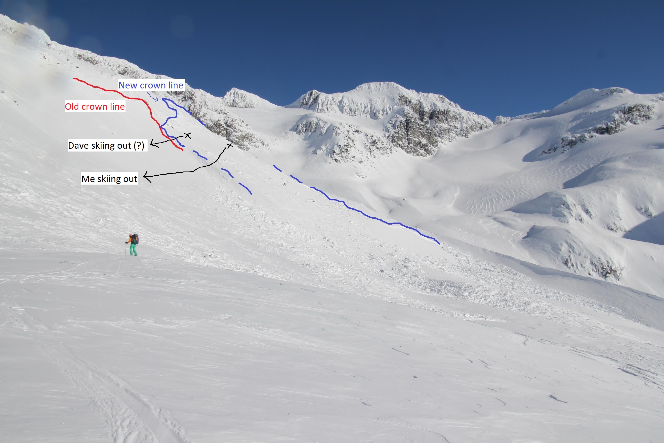
Photo by Dave.
As I mentioned, the snow was very hard, like styrofoam, with no ski penetration. The hard surface wasn’t a crust over less consolidated snow—-it was hard underneath as well. I had thought (wrongly) that this sort of boilerplate was a sign of safety because it held the slab together. In fact, it turns out that hard slabs are analogous to persistent slabs: low (or moderate) probability, high consequence. A stiff, hard slab supports the weight of the skier and reduce the stress on the weak layer below (called “bridging”), and this means that hard slabs are more difficult to trigger. However, if you do manage to trigger a weak layer, the slab stiffness means that it is (i) more likely to propagate and cause an avalanche and (ii) the avalanche is likely to be larger in area. I noticed that the avalanche came down in big solid blocks, and I would speculate that being hit by them would be more dangerous than a soft slab, too. A problem with calling hard slabs low-probability-high-consequence is that the thickness of the snowpack is often variable. If you happen to ski over a thin section (i.e. short distance between your skis/mass and the weak layer), triggering the avalanche may be HIGH probability, but then it can still propagate into a big high-consequence chunky avalanche.
There were a few risk factors we might have picked up on for avalanches in general that afternoon, and we were lucky that we triggered this (relatively small) slope rather than one of the more serious slopes earlier in the day. For one thing, it had been ~-20 C the previous night, but the day of the avalanche it warmed up significantly to maybe ~-5 C. It was 4:30 PM, so the SW slope had probably been heating up in the sun for a couple hours too. We had also noticed that the snow higher up in the alpine was wind-affected and crazy variable, so it shouldn’t have been surprising that hard slabs would form in some places. As I said, what convinced me that the slope was benign was that it was that the surface did not show signs of melting—not soft or slushy. Turns out that’s probably not a good way to evaluate solar warming.
What should we have done differently in terms of decision-making? Maybe we should have weighed the risk factors in the last paragraph more carefully. Bruce Jamieson’s lab has put together a tool, called SWarm, that can help evaluate the risk from solar warming. Birgit has put together a summary of the tool, where the output is the daytime warming 10 cm down in the snowpack due to sun. The model was calibrated in Rogers Pass with drier snow, so it will tend to underestimate warming on the Coast (and there are other caveats to this model that you should look into if you want to use it!).
Our choice to zip across this slope (and other small slopes before it) as a shortcut was not the most conservative option, maybe because we were quite close to camp and eager to get there. It would have been simple, but slower, to traverse under some of these slopes on mellower terrain, although in these conditions there might have been a risk of remote-triggering an avalanche on the slopes above. There is one uncomplicated thing I should have done to reduce risk: I could have followed farther behind Dave to limit the number of people exposed to the slope at once. Alex kept much farther back, and this meant she wasn’t caught in the avalanche even though it propagated far out towards her. I and the people I ski with generally don’t space out enough in avalanche terrain, in retrospect. Finally, this was the first south-facing slope of the day. It might have been worth probing more carefully for a weak layer as we left behind the shady north aspects.
Anyway, even though this happened nearly a month ago I figured that people mostly stuck in the city might still be interested in reading about skiing (and avalanches). Captive audience… Also, I know there are some very knowledgeable people in the VOC who could correct or expand on some this.
Thanks for sharing. I found this informative and helpful especially since I am quarantined out in a place where running into avalanches is still a concern.
Glad you liked it!
Thanks for the summary and coming forward to share your experience with us.
I’ve looked into SWarm previously (including this past winter, in detail on March 16th)… and found it’s only a very rough estimate at best, and somewhat more useful on solar aspects than shaded or northerly aspects. I’ve struggled to find a practical use for it at work (highways avalanche forecasting) and my personal view of this tool is that it needs to do a better job of incorporating the effect of radiative cooling. (see below for my example this winter)
I know some folks will look at me like I’ve been sniffing glue again, immediately jump up and say, “But wait, SWarm has a cloud cover component!” … my understanding is that the cloud cover parameter is for calculating incoming solar radiation, not its effect on radiative cooling. I put this very question to the good doctor (Jamieson) last year, and his answer was that there isn’t a good calculation of radiative cooling incorporated into this model.
I will hasten to add that Bruce has done some fine work determining the *truer* snow surface temperature (and by farther extension, T10) in 2016 and 2017… see the link below from the CAA spring conference for his excellent talk:
(https://www.youtube.com/watch?v=REUz39MjHzc&feature=youtu.be&t=45m43s)
Three key points are:
1) Snow surface temperature will be 8-10 degrees COLDER than the air temperature for clear sky conditions.
2) Snow surface temperature will be about 6 degrees COLDER using an IR thermometer versus what a traditional contact thermometer will measure.
3) Bruce says snow surface temperature measurements are of no practical use in avalanche forecasting(!)
So what did my experiment find this year on March 16th? (for the true Snow Nerds still reading this far)
There was previously dry surface snow on polar aspects (3 days since last snowfall, arctic outbreak conditions prevailed thereafter), overnight low of -13.5C (@ 8am), and a daytime high of +3.8 (@ 3pm)… SWarm predicted 5-7 degree warming on north aspects (slope angle dependent). So based on those numbers, you’d probably expect moist surface snow… but empirically we found cold dry snow on northerly aspects, which suggests the radiative cooling mechanism was winning.
All snow nerding aside, the practical actions one can take to mitigate avalanche risk are listed in Vincent’s summary: 1) travel spaced well apart 2) reduce your exposure by travelling in lower angled terrain (with minimal overhead hazard) as much as possible.
Thanks Mark—-good to know that SWarm is a bit unreliable. Not knowing much about solar warming, I found it interesting that the snow surface absorbs so much more heat a few days after snowfall, and also how strong the effect of cloud cover can be (but I guess what your saying is that SWarm doesn’t do cloud cover all that well).
BTW, at Sphinx last May I happened to read an entry you wrote in the logbook sometime in the early 2000s. 4 feet of water in the hut! I knew Sphinx flooded, but I had no idea it was that bad.
Thanks for the trip report Vincent. It is great to get insight into problems like this especially when everyone is okay.
The following is not to critique any of your decision making or thought process as I don’t know all of what you did but simply another insight on the situation that people could learn from.
I do remember that wind slabs were a big part of the avalanche danger rating during March. I was out on Paul’s ridge and almost got blown over for instance. Another thing that was interesting was that the winds did come from all different directions during March so cross loading was a concern. I know you mentioned the alpine was wind affected but normally we think of the winds from one direction. It does take some recalibration to be cognitive of where the winds could have affected the slopes.
Hi Vincent, I was out skiing not too far from March 12-17 and to be honest the snow conditions where for the least complex. As Nick said : wind slabs on all aspects, plus the cold snap with high radiation in the day… I was with quite experienced skiers (1 ACMG guide, 2 ops 2,…) and we triggered (on purpose but…) 3 size 1.5-2 avalanches on the 16, 2 being warmed wind slabs similar to what you described. I am glad none of you guys were hurt.
Thanks for sharing some valuable lessons learned Vincent! Scary incident and a relief there was no harm done. When I read reports like these they always remind me to be additionally cautious with March/April solar radiation, as I’ve heard about hard-slab release incidents under similar circumstances (no softening of surface snow but strong spring sun) many times before.
At our recreational level of avalanche knowledge, it seems a prudent approach might be: if it’s (1) sunny out and (2) it’s a spring transitional snowpack from mid-winter snow to spring consolidated snow (i.e., before the big spring melt/freeze cycles) and (3) we encounter a slope that’s seen the sun and that is above the threshold (>30°)—STOP and have a think: if I don’t have a high degree of confidence in the stability of this snow, why don’t I just find a mellow way around it?
From the picture it looks like your party was traversing and kind of zipped around the corner onto a slope when you could not see the angle (or old debris) as you traversed into it. Is that correct? That poses another challenge of not knowing what you’re heading into in terms of terrain if you can’t see what’s coming. I’ve also experienced that situation and ended up following or leading a party onto heinously steep stuff when a much mellower option existed below. I suppose experience teaches us to recognize when we’re about to head into something we can’t properly see, and before we get to a point of no return, stopping and re-assessing with the group, perhaps having someone scout out while communicating to the main group before sending everyone ahead.
All of this re-asserts the value in emphasizing terrain selection, weather obs, and group management over snowpack evaluation, because the latter is just so uncertain!
Thanks Nick and Jeremie—-it’s interesting to hear that you also thought these were complex snow conditions (in mid March). Everything that day was cross-loaded in the alpine. The sastrugi were wild, with big thin overhanging sections, so the winds must have been crazy. I know that the day of this avalanche there were 3-4 skier triggered avalanches on the MIN south of Pemberton, so it was clearly a bad day. The challenge I guess is to identify bad avalanches days like this ahead of time. Probably paying closer attention to warming temperatures throughout the day would have helped. I’ve also decided to dig a little more, especially if there’s some spare time during a slow transition for example.
Good point about the warming, Elliott. The importance of subtle solar warming is one of my big takeaways from this too, even though the slope was was probably shaded for a good chunk of the day (there’s a big ridge just S of it). Yeah, we didn’t really see the slope until we were on it. I was actually rushing to catch up to Dave, because he had disappeared around the corner and I wanted to keep him in sight. I think part of the problem here is that we’d been traversing very similar slopes for 500 m beforehand—-but these were slightly less than 30 degrees, and they were more shaded. I think this made the change to slightly more sun-exposed, steeper slopes less obvious, especially since every other slope we had skied earlier that day had been much bigger and totally shaded. The other factor was that the snow surface was bulletproof, which gave me misplaced confidence.
I talked this over with Lea Z too (who does hwy avalanche stuff) and she said that skirting the toe of the slope would have likely been fine wrt remote triggering
Thanks so much for your honesty in this report Vincent!
Solar warming effects can be tough to predict. ACMG guide Robson Gmoser (Hans’ son) was killed in 2015 in a slide where solar warming of a PWL was listed as a major factor.
Do you think the general warming of the snowpack could have contributed? This is certainly assosciated with increased PWL and DPWL activity. For what it’s worth, I carry a digital thermometer almost all of the time in the backcountry to check snow/air temps (NERD ALERT) and sometimes the temperature gradient can be very surprising.
Yeah, it does seem that warming was a factor (and the avalanche canada people mentioned this too). Air temperature increased from about -20 C the night before to maybe -5 C or even warmer by the evening. I’d like to get a thermometer too! I’ve been meaning too for the last year, but I’m a little suspicious of the standard MEC keychain ones that fluctuate by 5 degrees or something.
This is so awesome seeing a detailed account on your incident, and I absolutely love all the snow science nerdiness. Thanks Vincent for sharing! I’d like to add a few points to help with future decision-making. Note: I don’t meant to judge your decision-making in any way, I only aim to build upon the skills you already have. It’s so easy to dissect someone’s decision-making from the couch (called “armchair alpinists”), and I appreciate you posting this report. It highlights some unusual characteristics with a specific overlap of avalanche problems and changing seasonalities within the snowpack.
Echo-ing Elliot’s comments, terrain management is the key. While I love and appreciate the snowpack discussion we’re having here, ultimately at a recreational level, terrain choice is our steering wheel through higher danger ratings. If it’s likely to trigger an avalanche by humans (which on that day would be true because it was considerable danger), it’s best to dial back your terrain choice, especially with many known uncertainties.
Talking about the snowpack that day though, I too was out in the backcountry on my AMGA aspirant ski guide exam across the valley on Rainbow Mountain. We dealt with the same thing, getting whumphing in thin areas on solar aspects in the alpine. The key point here is that we were getting whumphing in THIN areas ONLY, NOT whumphing overall. We call this concern going “thick to thin,” as in, in general the thickness and hardness of the slab will bridge above the weak layer of concern, but in thin areas it can be easy to trigger a buried weak layer. In these thin areas there’s a few factors at play making it more likely to trigger a deeper weak layer: 1) overall snow depth is generally shallower around rocks because of absorption of solar radiation, meaning that it’s easier to trigger deeper weak layers since the force of your weight applied onto the slope (i.e. your force bubble) can reach deeper into the snowpack, 2) rocks encourage the process of near surface faceting, which develops more weak facets overall and 3) rocks will absorb solar radiation on very sunny days, contributing to a weakening of the snowpack around these features. In general, avoiding thin areas where this is a problem can alleviate this concern. How does one do that you might ask? Well, pulling out your probe and feeling for the depth of the density change can be a great tool.
On your point Will, studies have shown that measuring snow temperatures in the upper 10cms of the snowpack is likely to fluctuate significantly based on radiation absorption from the tip of the thermometer. Hence, temperatures measured for shallow depths have very little accuracy and can fluctuate up to +/- 10 degrees C . Having also been out touring that day just across the valley (Rainbow Mountain), I can speak on behalf of the snowpack there and that yes, the wind slab that was present that day was quite shallow (approx. 15-20cms thick), but quite hard (nearly pencil in hardness). For these conditions, I doubt that measuring snow surface temperature with a thermometer would be a very useful decision-making aid. However, something I noticed that day that was alarming was that the weather forecast did not predict strong solar warming; we were even joking with each other that it was the least cloudy partly cloudy day any of us had seen. The key takeaway here is that the avalanche bulletin is built around weather forecasts and snowpack data from professionals; hence if the weather changes, it’s useful to assume the avalanche danger and bulletin should change as well. Be on the lookout for these changing conditions, and adjust your hazard, and hence decision-making accordingly.
Some additional takeaway points to add here Vincent:
1) Using Pits as a Decision-Making Aid: I noticed you mention “I could just dig more pits” on one of your followup comments. I would stray away from this. Remember that while pits can be a useful decision-making tool, they’re mostly useful for the following objectives: 1) identifying depth/distribution of persistent weak layers, 2) developing an overall understanding of the snowpack structure in an area that either lacks information on the snowpack or doesn’t have a posted avalanche bulletin, or 3) identifying the likelihood of human triggering on a slope that has a very unique and generally consistent snowpack structure throughout the feature. In general, pits need to be highly targeted and objective-oriented. However, the limitations of pits are many, The other consideration too is: okay, so you dig a pit, but what are you going to do with that information? Generally, a HUGE heustric trap is using pits to try to “prove” that the snowpack is stable; but because of exceptional spatial variability of the snowpack, and because 15% of results are false stable results in snowpack tests, this isn’t the best approach. I generally like to say “your snowpit can turn you away from big terrain, but not choose to go into bigger terrain.” I’ll generally decide if I aim to try to commit to bigger terrain before I even head out, then try to identify red flags or reasons to decide to turn around, rather than vice versa.
2) Visualizing Terrain Before Approaching It: Using terrain decision-making aids, such as smartphone navigation apps like Gaia, Avenza, CalTopo, Hillmap, Fatmap, etc can give you a great idea of what the terrain is like before committing to a slope. My general rule of thumb is, if I’m “onsighting” (i.e. going to an area that is new to me), I’ll do extensive route planning and at the very least, download the slope shading layer AND a topo map layer onto one of the navigation apps I listed. In general, if I can’t see the whole slope/feature I’m about to ski, I’ll reference my navigation app. This will give you a better idea of visualizing terrain before you’re committed to it, even if you haven’t been there before.
3) Committing to This Slope: In general, I like where your head is at with trying to find instabilities on smaller slopes. The best evidence for avalanches is either seeing avalanches or triggering them yourself; so if one can do that on small slopes, that’s awesome! However, something to keep in mind is that any slope capable of producing a size 2 or greater avalanche is not small. Small slopes would be at the maximum, even for very deep instabilitilies (75-85cms deep), produce a size 1.5. Finding these sized slopes, and trying to cause an avalanche (either by ski cutting, jumping on a baby cornice, etc) is highly valuable information.
Okay that’s all I’ll add for now. Thanks for your detailed writeup and for starting a great conversation!
Thanks for your thoughtful comments Zack. Interesting that the weather forecast that day was for partly cloudy. We were camping the night before so I didn’t know that. It was definitely sunny out though! By the way, the avalanche forecast that day (March 15) was M/M/M, not considerable——although given how many skier-triggered avalanches there were, I do think it’s possible the conditions were worse than predicted.