The trip came together relatively last minute. We were chatting one day about Alberto and Lucy’s previous trip biking in the Chilcotins, when Richard mentioned that he had long wanted to visit Mount Vic. Could a bike-accessed hike to Mount Vic work? Yes, it could, but wouldn’t it be more fun to do a loop on the bikes rather than an out-and-back? So we got to work planning an eight day trip with about a week’s notice. Our one concession to the short planning time was that we left Vancouver on Saturday morning, rather than the traditional Friday-after-work thing.
Day 1: Vancouver to Relay Creek Road
After a 7 hour drive, we reached Relay Creek Road on the eastern side of South Chilcotins Provincial Park. Before heading off, we tested our bear sprays and noticed a bit of liquid bear spray had dribbled onto Richard’s finger before the spray kicked in. Obviously any one of us would have done what Richard did next: lick his finger to see how it tasted. But perhaps some of us would have done a better job of remembering to be careful when we had to pee five minutes later. Suffice to say it was a spicy start to the trip.
It was 4pm by the time we started cycling, and we reached the proper trailhead (4WD / extremely HC) at about 7pm. The map shows it as a camp site but it wasn’t much, just some flat ground, much of which was occupied by two burly trucks (we assumed from hunters). We decided to make camp for the night anyway, rather than continue another few kilometers to the better site at Relay Cabin.
We were fast asleep at around 10:30pm when we awoke to the sound of gunshots, followed a little while later by the sound of people making their way back along the trail. Alberto stuck his head out of the tent to let them know we were here, which seemed to startle them, but they got into their car quickly and drove away, as we drifted back to sleep.
Day 2: Relay Creek Road to Airport Meadows
The next morning, we were finishing breakfast when the owners of the second car showed up. They were also hunters, and told us that they had been camped at Relay Cabin when the first party from the night before had fired shots extremely close to their tent. Apparently the first party had had a grizzly come into their camp earlier in the evening, and had decided to pack up camp and hike out through the night. They supposedly thought they saw a cougar when they fired the shots at the second party’s tent. The second party was obviously not impressed by any of this, and we were left wondering which hazard to be more concerned about, bears or people? (Spoiler alert: It was bears).
The morning drama behind us, we got to cycling along the Relay Creek Trail, soon passing the cool log cabin where the shooting drama had happened the night before. Definitely more aesthetic than our camp at the trailhead, but we were content knowing that we had (literally) dodged a bullet in deciding not to camp there.
There was a bit more up and down than we anticipated for a trail that follows a valley, with mandatory pushing on the ups because of the heavily loaded bikes. We enjoyed some really fun singletrack as we arrived to Graveyard Cabin, another old log cabin with great camping potential. After a long lunch in the sunshine, we rode the few kilometers to Airport Meadows, where we would leave our bikes for three days of hiking. It took most of the afternoon to transition from bike to hike mode and cache everything we didn’t intend to bring, so we ended up just camping there too.
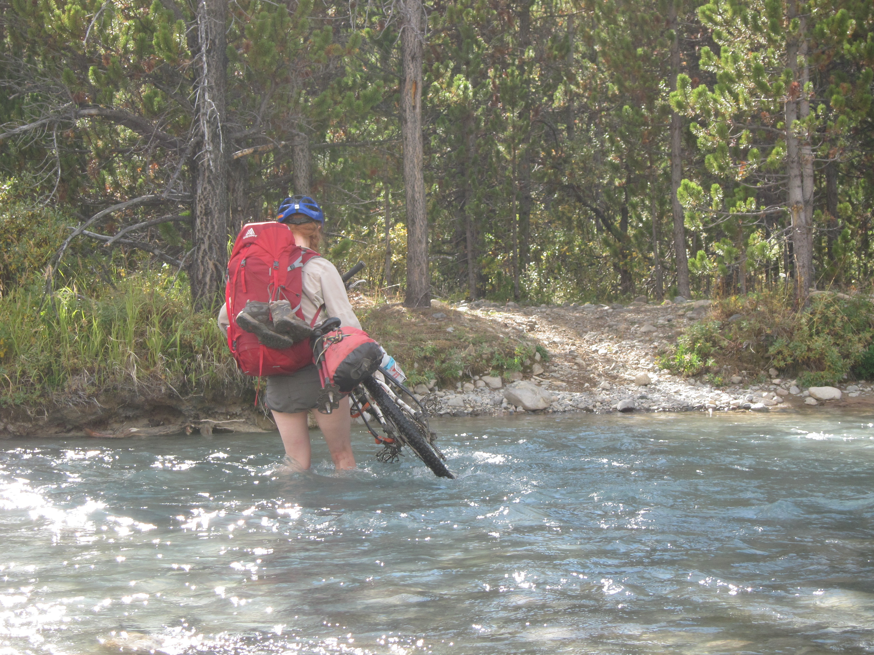
Crossing BIg Creek on the way to Airport Meadows (Photo by Alberto Contreras)
Day 3: Airport Meadows to Vic Lake
It rained overnight, so it was full waterproofs for the bushwack up to the Dil-Dil Plateau. The forest was fairly open, with lots of bear trails that we made use of, with increasing trepidation as we kept finding more and more gigantic piles of bear poop.
Once the ground started to level out, we knew we still had to gain a bit more elevation to get onto the plateau proper, but figured travel was easy so we didn’t need to worry too much about our exact route. This turned out to be a mistake as we ended up wading through chest high blueberry bogs with no real escape route in sight. It was around this time that Lucy spotted a mama grizzly and three cubs across the plateau. Far enough away that we were not concerned, but we altered our course anyway (to the extent possible in the bog) to be heading away from them rather than parallel. A few minutes later realized they had covered a LOT of ground towards us and were now only about 100m away. The cubs stood up to get a better look / smell of us, as we backed away as calmly as we could through the bush. Luckily, the mama decided we were not of interest and they all headed away from us, but we were still on edge given the lack of visibility. It was an interesting game of trying to progress through the bog while keeping an eye out behind us in case they returned. When we finally made it up onto the main part of the plateau, with sightlines in every direction, we breathed a big sigh of relief.
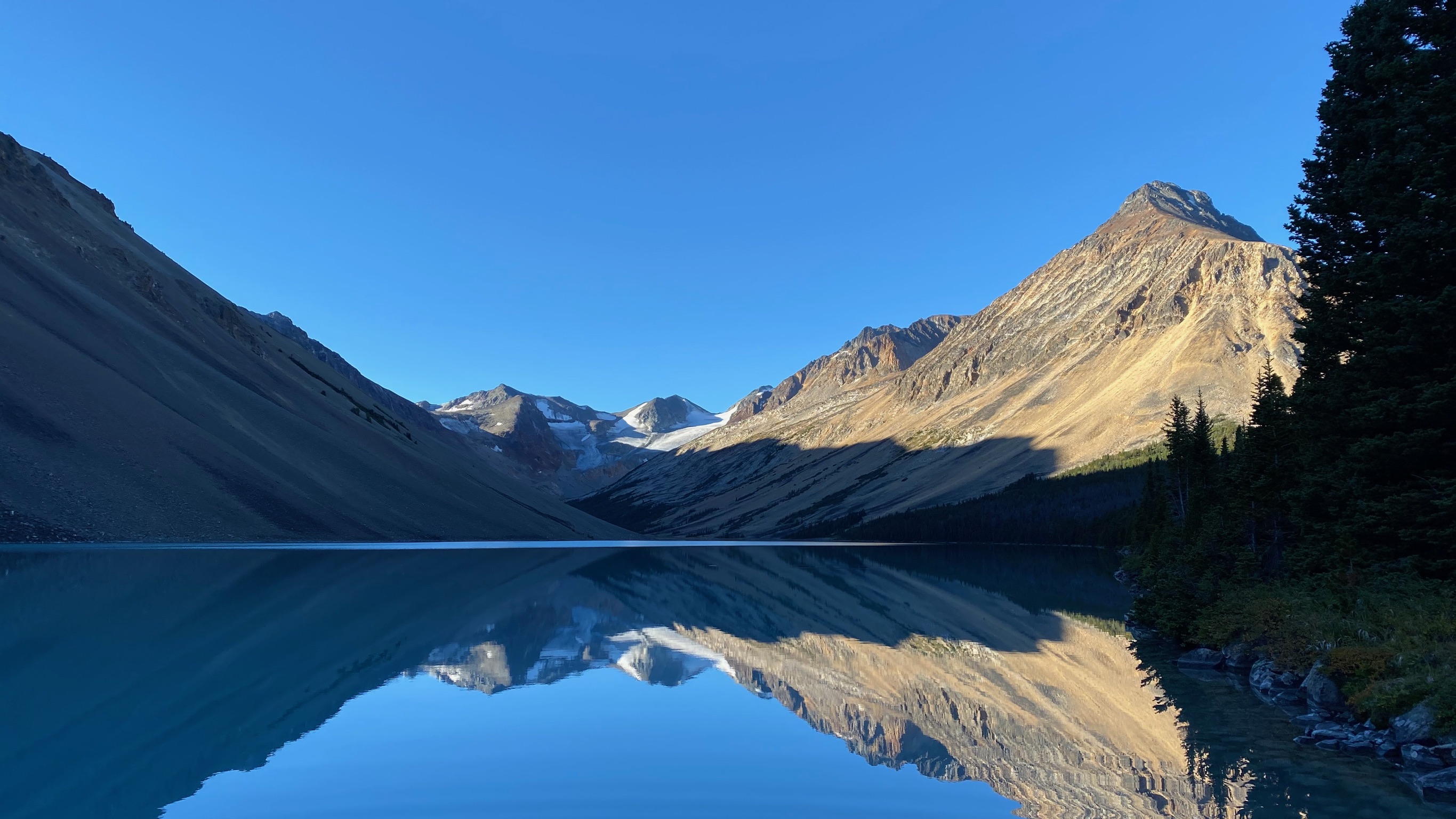
We had a few options for our route to Vic Lake. We opted for the least grizzly-est and most scenic, along a ridge on the eastern edge of the plateau. As we made our way along the ridge, we scouted Mount Vic, our supposed main goal of the trip. There seemed to be a glacier blocking our intended route, and the final slope to the summit looked impossibly steep. We remembered a Bivouac trip report that said “Mount Vic looked unclimbable” and went on to describe how the participants climbed it, but it still really looked unclimbable.
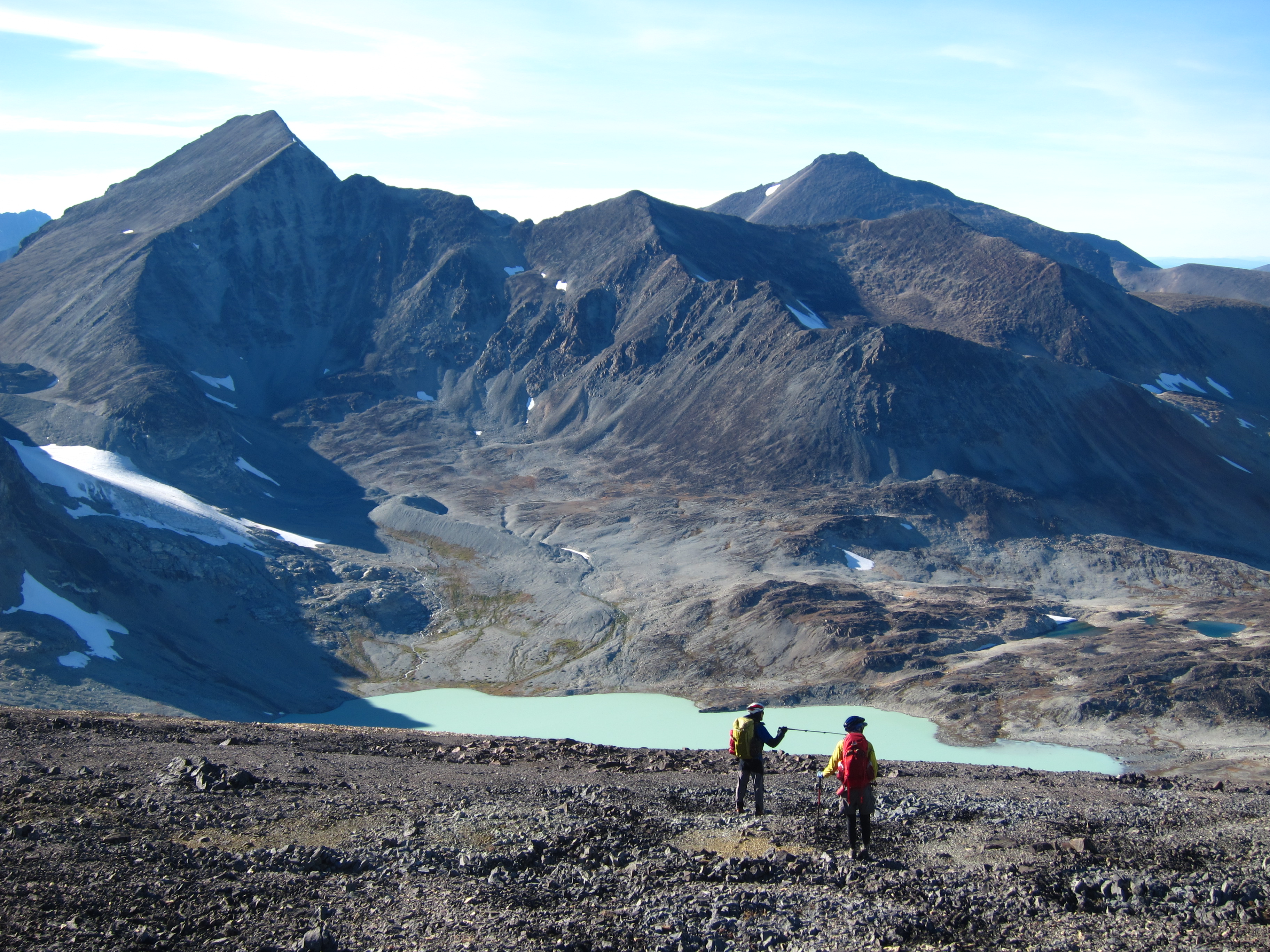
Descending to Vic Lake, Mt Vic on the left. (Photo Alberto Contreras)
Day 4: Vic Lake to Dil-Dil camp
The next morning we set off to check whether Mount Vic was climbable or not. There was some steep, loose scree, but we were able to get past the glacier, up the headwall, and onto the col. Richard decided he had had enough of steep scree and waited at the col while Alberto and Lucy continued up the (thankfully less loose) final slope. The reward was a view of Mount Waddington from the top! Along with the Homathko Icefield in one direction and the Chilcotin Plateau in the other. At officially 3005m (slightly less on our GPS), it was the highest we had been in BC.
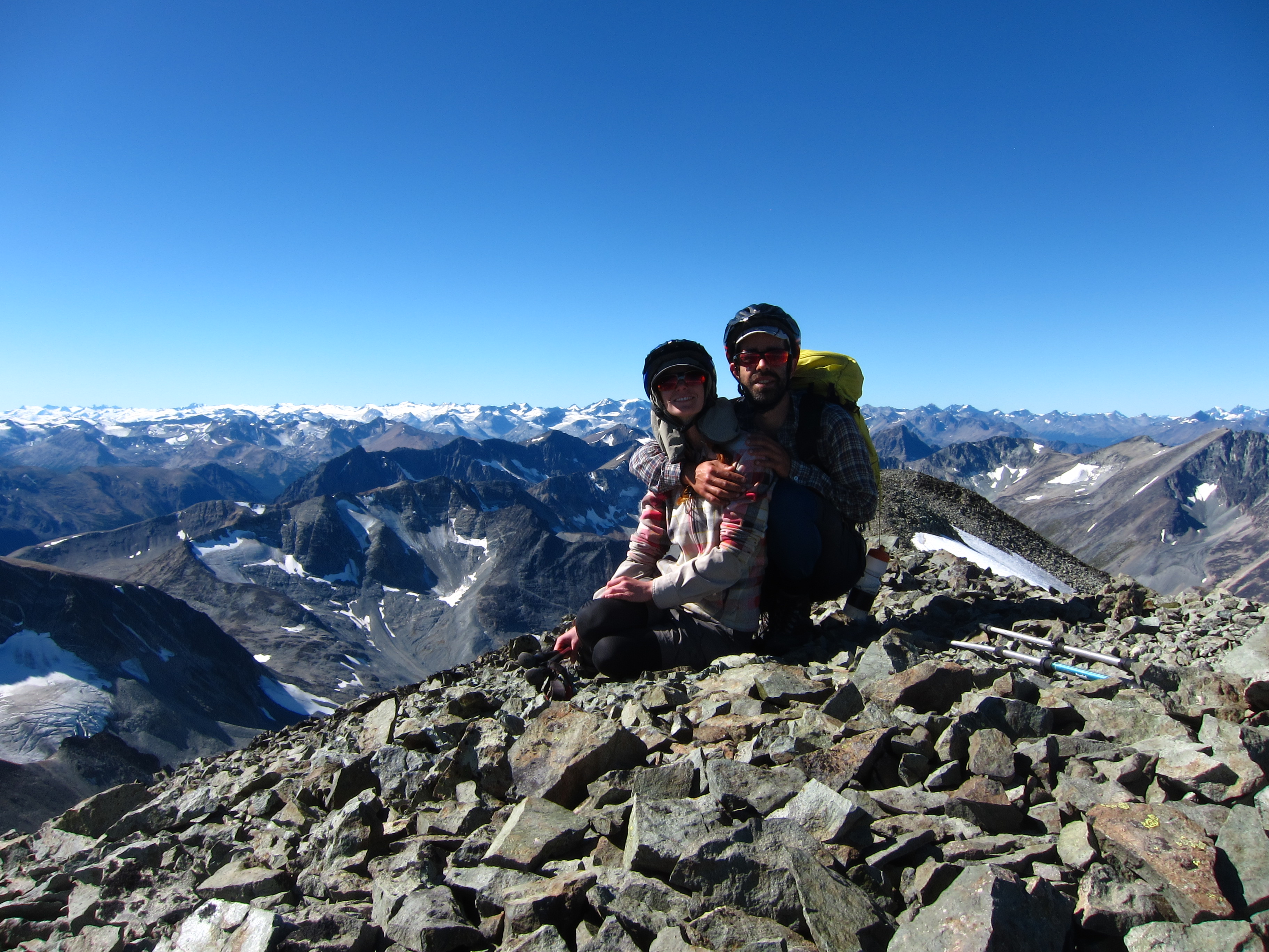
Mt Vic Summit Shot… Homathko Icefield in the background (Photo by Alberto Contreras)
We were back in camp by mid-afternoon and decided to make a bit of progress back across the plateau. We set up camp on the perfect flat spot above a stream, and watched the alpenglow light up the south chilcotin mountains as we ate dinner.
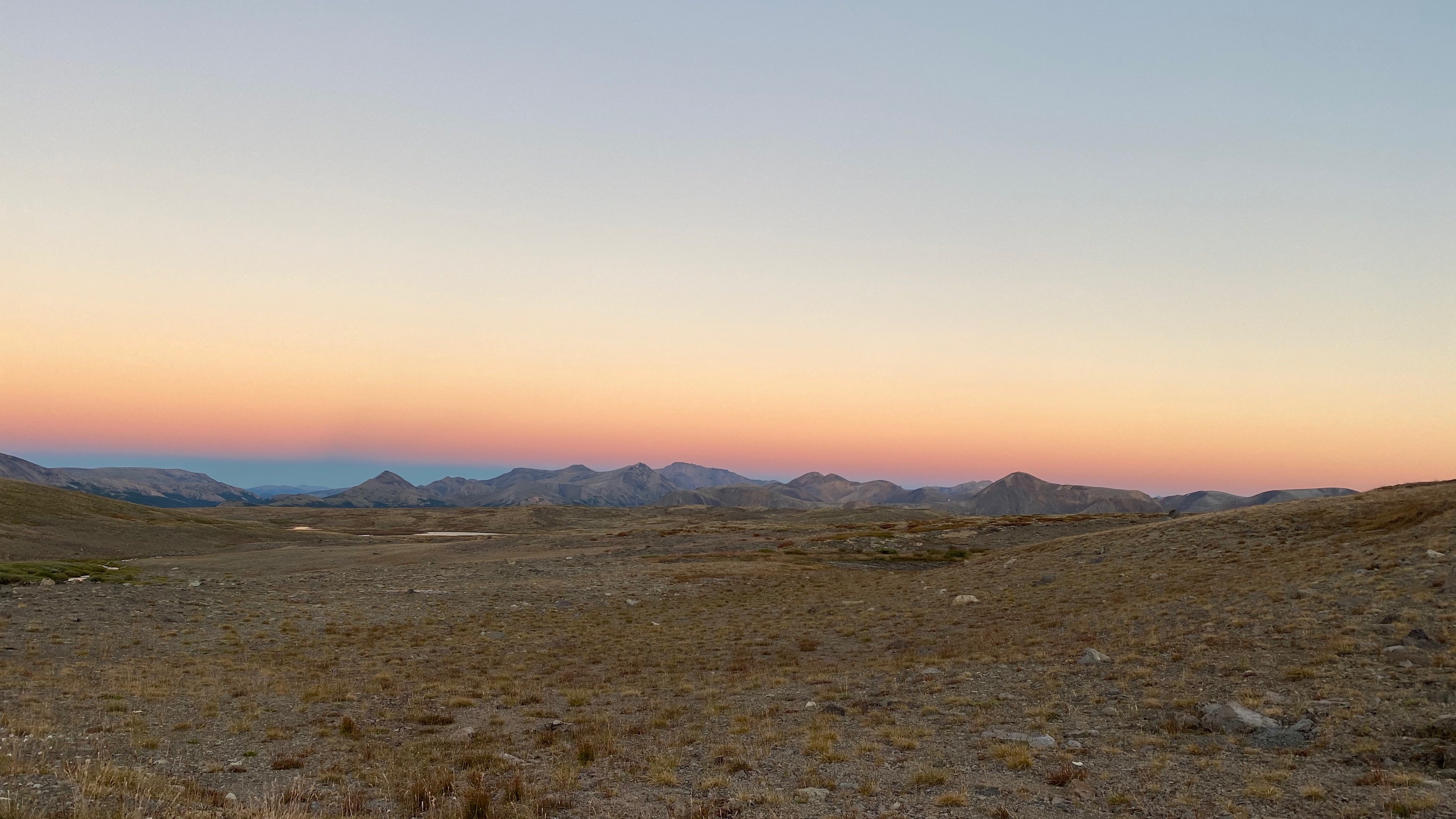
Sunset on the Dil-Dil Plateau (photo by Richard Shaw)
Day 5: Dil-Dil camp to Lorna Lake
We were apprehensive about crossing “grizzly bog” to get back to our bikes, and made sure to stick to high ground as long as we could, before quickly and noisily making our way through a small patch of waist-high berry bushes to arrive at the end of the plateau. Then we scouted a more open way down through “grizzly forest”, and sang loudly all the way down. It was a relief to make it back to Airport Meadows and find all our cached stuff intact.
We transitioned to bike mode over a long lunch in the shade, ready for our afternoon ride to Lorna Lake. It was slow going, with a few creek crossings and some muddy sections we had to walk, but we were looking forward to getting to camp on the early side and maybe even going for a dip.
Suddenly, as we were approaching the crossing of Sluice Creek, Lucy let out a loud, high-pitched scream of terror, followed shortly by a slightly deeper yell from Alberto. There was a grizzly running full speed towards us! There was no time to do anything but brake and yell, before it veered off at the last second (at about 5 meters away) and ran off into the forest. Richard, who had been cycling a few meters ahead, was the only one with the presence of mind to get out his bear spray as we watched the bear’s butt disappear into the bush. We were less than 2km from camp at this point and ended up walking most of the way because we were too freaked out to ride.
We hoped to find another group camped at Lorna (what an unusual hope!), but no such luck. We sat by the lake and stress-ate a full package of shortbread cookies while we analyzed what had just happened. We had been yelling frequently as we biked along, but we speculated that with the creek so close, the bear might not have heard us. We discussed, without coming to any conclusions, if this had been a true “bluff charge” or whether the bear was running away from Richard, and just happened to run in the direction of Lucy and Alberto. Either way, it was far too close for comfort. We discussed various options to avoid ever experiencing that again, such as switching to winter-only backcountry pursuits, or moving to Europe.
But there was a more immediate decision to make. Our original plan for tomorrow had been to backtrack 5km up the trail we had just come on, to take Elbow Pass — but that would mean going past “grizzly creek” and wandering through a bog to find the Elbow Pass Trail. It wasn’t hard to reach consensus on NOT doing that and instead taking the more direct Lorna Pass which would take us to the same place.
Lorna Lake is calm… we are not. (Photo by Richard Shaw)
Day 6: Lorna Lake to Spruce Lake
Next morning, we were on track for our earliest start yet, when Alberto realized he couldn’t find our water treatment drops. What started out as an annoyance of having to unpack all our bags turned into a bigger problem when we realized we still couldn’t find them anywhere. After a final search of EVERYTHING, we concluded that Alberto had left them at a creek crossing about 5km back. We discussed our options. That trail section wasn’t very fast going, it would probably be almost as fast to walk it, and it might take a good half day to get there and back. We did have some spare time, so this was feasible, just annoying. (Plus, we would have to go past “grizzly creek”!). We still had four days left in our trip — we could try to make do without the drops, selecting streams carefully, and probably had enough fuel to boil water in the worst case. Finally, we settled on reverting to our original plan of riding back up the trail and doing Elbow Pass — this way we wouldn’t be “wasting” any time, and we’d have the drops back. It turned out we were more scared of giardia than grizzlies.
We re-packed our stuff, ready to set off into grizzlyland. Then, as Alberto went to put his helmet on, there they were! He had put the drops into his helmet (which was hanging from his handlebars) and forgotten about them. Lucy and Richard cursed him, but happily changed plans back to going over Lorna Pass, with some newly treated water.

Cresting Lorna Pass (Photo by Richard Shaw)
The push up Lorna Pass was less challenging than expected and only took about an hour. We were rewarded with awesome alpine views and a super-fun singletrack descent down to Tyaughton Creek. The Mid-Tyaughton Creek Trail had lots of sidehilling punctuated by short, sharp descents and climbs that usually required pushing. We were still making lots of noise, even though we secretly believed that we wouldn’t see any more bears now that we were on more well-travelled trails. Then Richard came around a corner to see another large grizzly moving quickly down the meadow from the trail. So much for our false sense of security. At least it seemed to genuinely want to get away from us and we were able to pass by quickly without any trouble (unless you count Richard cycling along a sidehill with safety-off bearspray in one hand as trouble).
We continued on the trail, shouting even more frequently than we had previously thought possible. We were ready to get to the relative safety of other people at Spruce Lake. About ten minutes later, Lucy took a good tumble down the sidehill when she attempted to put her foot down on the side of the trail, but found that she put her foot down into thin air instead. She and her bike ended up upside down a few meters below the trail. Richard, who was still in front but had heard the commotion, was back within minutes with his bear spray out, ready to spray the grizzly he was sure had attacked. Luckily, no one was injured by overzealous bear spray usage or in the fall itself, and we soon found ourselves crossing Tyaughton Creek for the last time before a short push and fun ride into Spruce Lake on the WD trail.
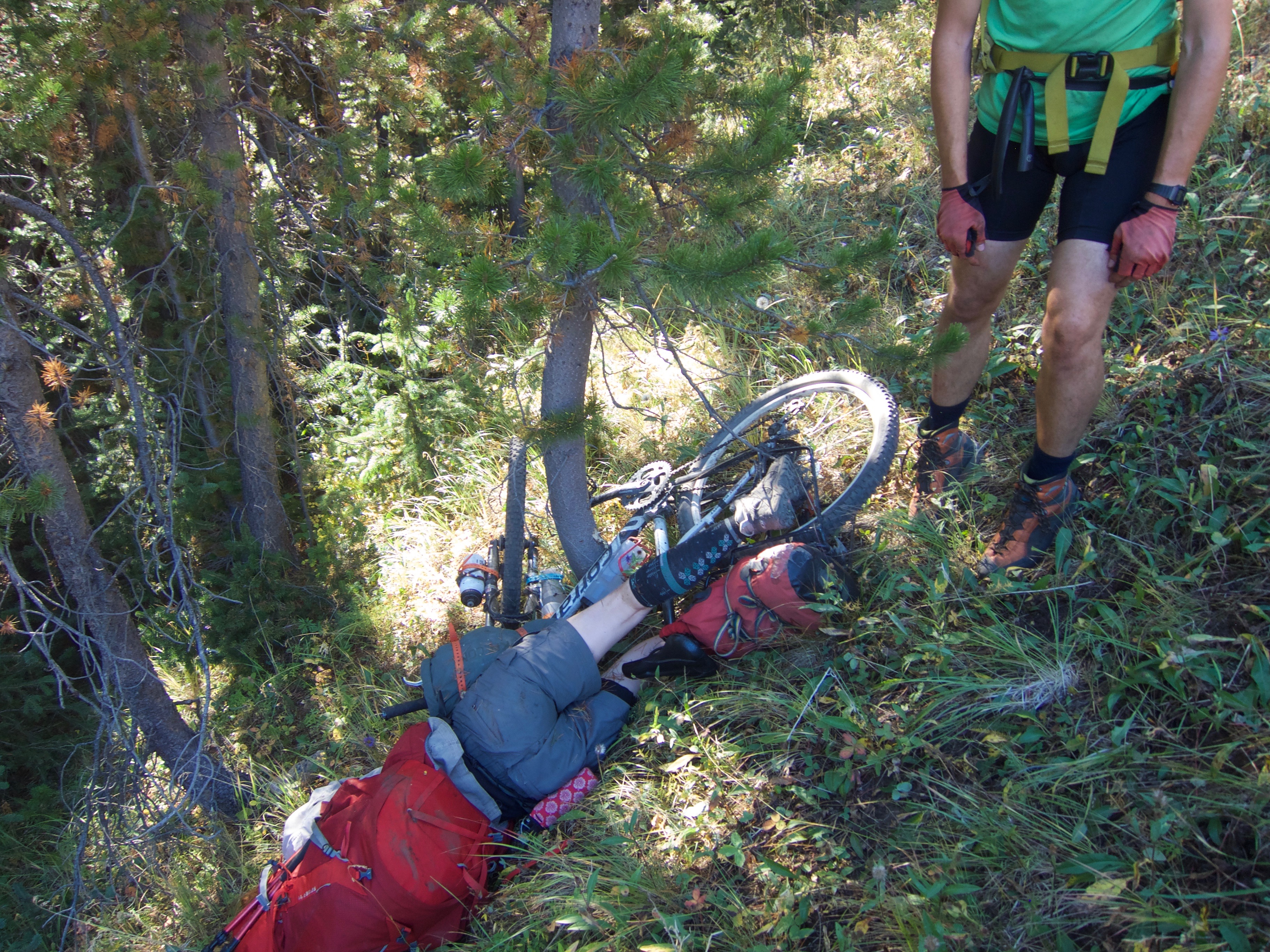
Lucy takes a spill. (Photo by Alberto Contreras)
Day 7: Spruce Lake basecamp
We had a lot of ideas for what to do with our spare day at Spruce Lake, but in the end decided to hike along Sheba Ridge to Mt. Sheba, a somewhat long day hike but one that was reportedly beautiful. (The idea that we’d be less likely to surprise another grizz while hiking a ridge may also have factored into it). It was already stinking hot within minutes of leaving camp and we thought we’d better make sure to refill our water before gaining the ridge. A few minutes later, we passed the first of many dry drainages. The rest of the park was full of creeks (although admittedly the trails were much less muddy than last year), but it seemed that this particular slope had no running water at all.
It was pretty clear we weren’t going to make it to Sheba, but we carried on to check the last two creeks shown on our map before the ridge. We got some nice views while we did that, but those creeks were also dry as expected, so we turned around.
Day 8: Spruce Lake to Tyaughton Lake via High Trail
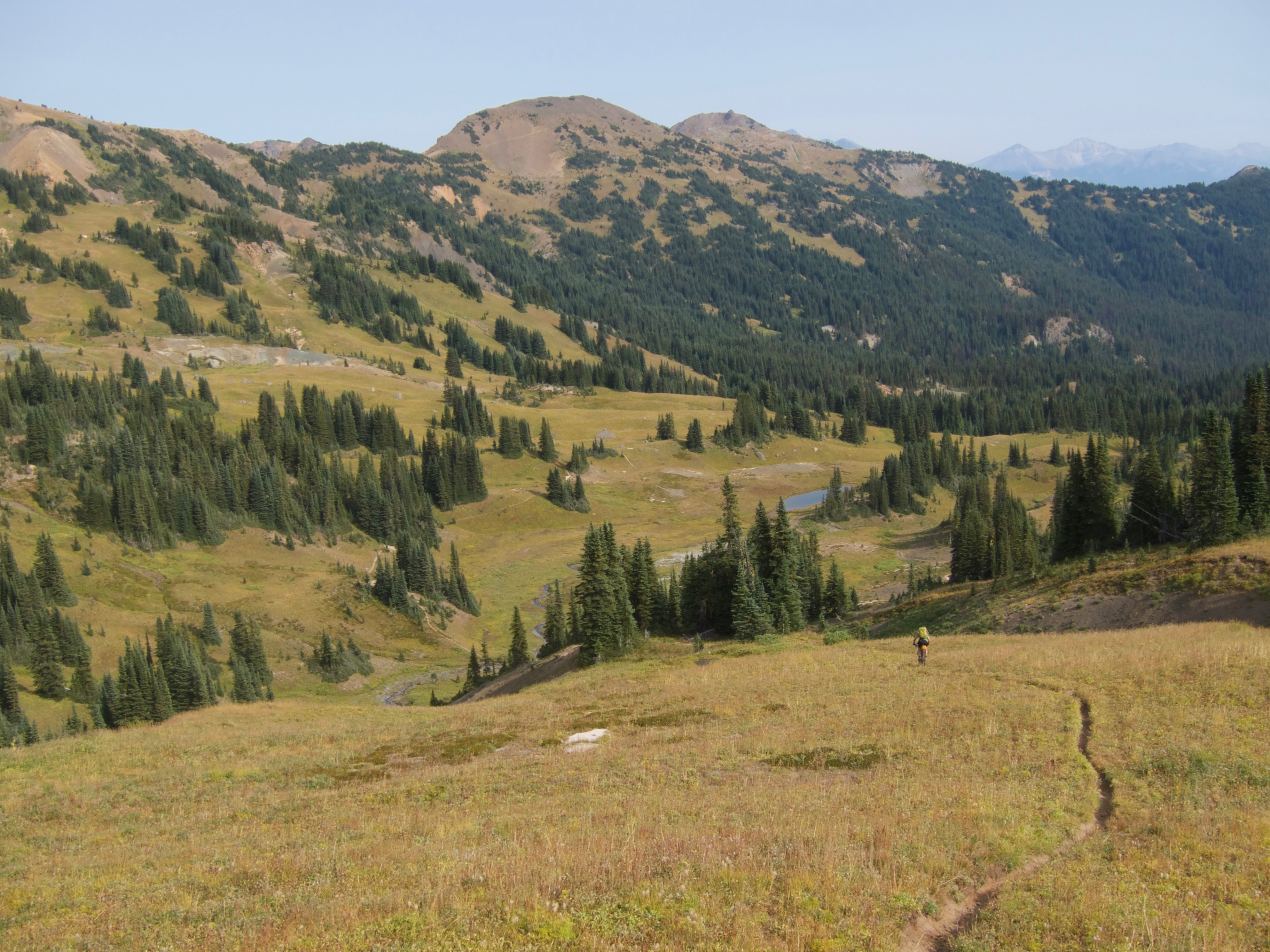
We pledged to get going early on our last full day, knowing that we had 1,000m to gain on High Trail, mostly by pushing our bikes. Fortunately, the heat from the day before never totally arrived (we later learned this was due to the US wildfire smoke beginning to arrive and blocking the sun’s heat, although it wasn’t really noticeable yet). We were never really sure how long the trail would take us so tried to keep a good pace as we pushed up to Windy Pass, rode back down into the beautiful meadows, and then up and over Pearson Pass.
Richard shreds the descent of High Trail (photo by Alberto Contreras)
The final descent turned out to be the crux of the day, first with a steep and loose section of trail that we were barely able to walk our bikes down, and then with the final descent on the steep logging road that forms the last section of High Trail, where we had to stop several times to let our disc brakes cool off so they would work again. But we still made it to Tyaughton Lake at a reasonable hour. We had learned via inReach that our friends Rick, Anna, Mandana, and Iliad were at the Tyax campsite, so we joined them for a night of relative luxury for our final night. It was great to end the trip by sharing stories and laughing with friends (and we may have enjoyed some of their car camping beer, too!)
Day 9: Tyaughton Lake to Relay Creek Road
All that was left on our last day was to ride the 25km or so up the logging roads back to our car. As we packed up, we realized that the smoke had fully arrived overnight and we’d be doing these final few hours in the haze. The roads were quite enjoyable, but we ended up walking the steeper hills rather than doing intense cardio in the smoke. When we arrived back at the car on our third straight grizzly-free day, we had almost relaxed enough to say that the trip had been a total success!
Amazing pictures and report! Wowww… It is so beautiful out there!
But I would also be terrified of meeting grizzlies, yikes!
You guys sure covered lots of ground! I wonder if the grizz activity was so high because they are leaving the alpine to head to the rivers in preparation for the salmon run?
In any case, I’m glad the trip over the Dil-Dil Plateau was a go. Mt. Vic is just a giant scree and talus slog; those always seem to look steep from afar but are easy up close.
Great write up. Where are the bear photos?
In our previous trip to the area we hadn’t seen a single bear…Who knows, but yes, maybe they were headed toward the salmon run. The guide running the horse operation out of Tyax adventures did say he sees 1-4 every day, so I actually don’t think it’s so unusual.
Dil Dil was amazing in every way, and the view from Mt Vic super awesome. Thanks for your guys’ advice and snapshots of the book