I’ve been getting complaints that my trip reports peaked a while ago. I can’t really argue with that. Even a few years ago, I was managing to end up skiing off something inadvisable by mistake and ending up in the dark, dangling from icy shrubbery sticking out of a cliff.
The easy way to address such complaints is to ski off something foolish.
The plan was to ski up from the Zopkios brake check to the top of Zopkios, drop into the Zopkios-Yak col and then descend to Falls Lake. From there it’d be a bit of a slog across Falls Lake, down the Falls Lake trail, and along the pipeline right-of-way from the Falls Lake exit back to the Zopkios brake check. This would be a pretty full day, but not ridiculous. It’s only ~12 km and ~1000 m elevation gain just looking at the topo, but there’s enough switch-backing, up-and-down on boulders, zig-zagging through dense forest, etc., that I was expecting a Neve-in-a-day kind of effort.
Our intended route

The ascent to Zopkios started out very boney, but relatively pleasant. As we worked up into the alpine, the snow got deeper and we were in a windy cloud. It was snowing considerably. There had been enough wind that yesterday’s snow wasn’t uniformly distributed, so we were seeing anything between a few and fifty cm on top of a sun crust. There were still boulders sticking out everywhere, so that you couldn’t have a sustained slide, but chunks of a few square meters would slide off very easily. We ended up in a long, steep gully where we’d need to kick-turn every three or for strides, fighting the slidy snow all the way. It was more of an arm workout than a leg day, with all the pulling on vegetation.
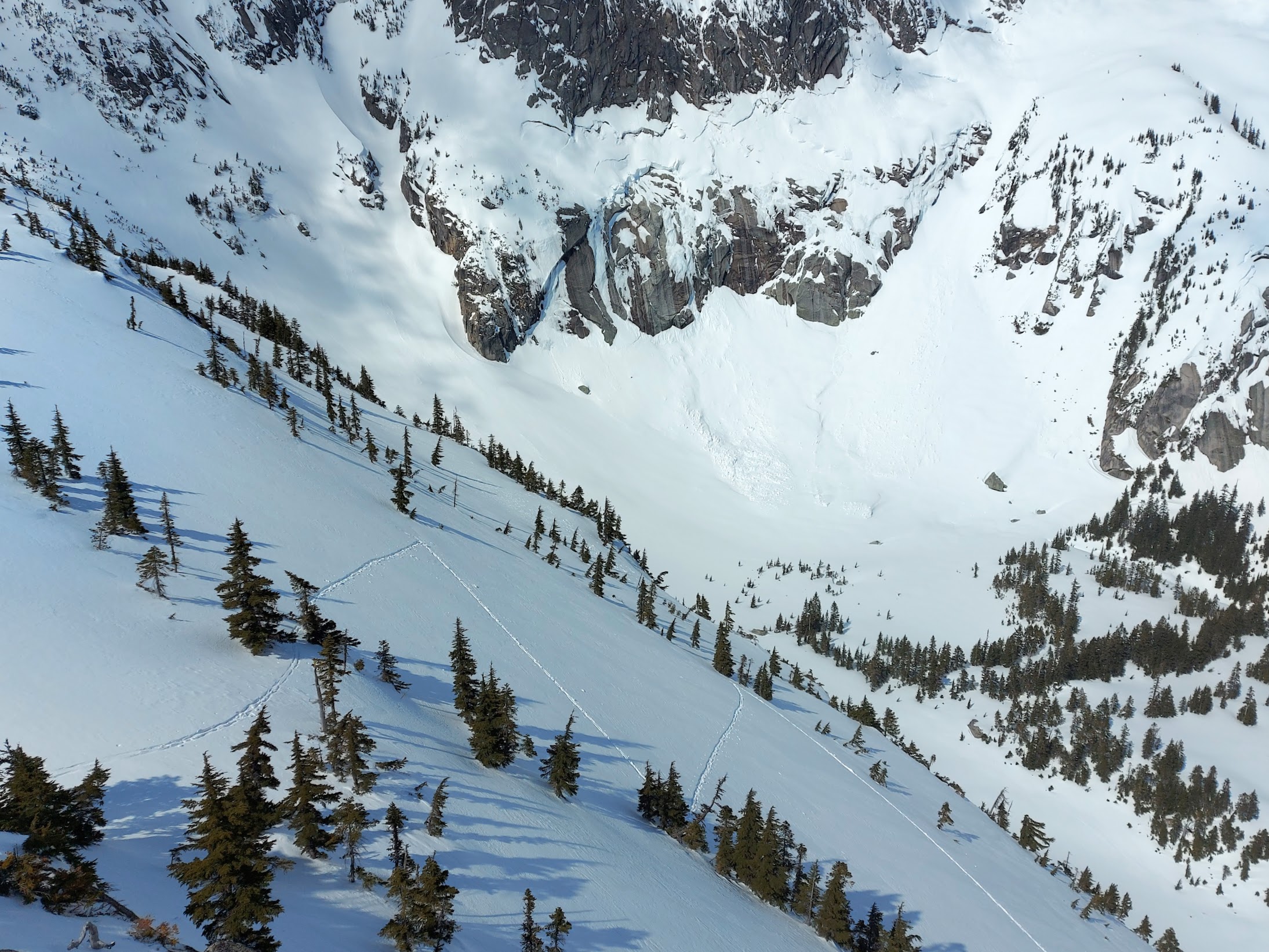
The conditions, combined with a very late start, saw us summit at about 3:00. I’d been to the top of Zopkios Ridge before. It seemed consistent; windy, krumholtz everywhere, rocks sticking out, can’t see anywhere.
If I’m outside and mostly looking a ways ahead all day, and then switch to looking at a phone or a book, I need reading glasses, so I got Devlin to look at the topo. He didn’t seem confident that we were in the right place. I asked him if we went down to the col, towards Yak. and went skier’s left from there, would we end up in Falls Lake. He said yes, so we started down towards the col.
It was significantly steeper than I was expecting it to be, with a thin snow cover. We scraped down to the rocks, and we had a spot where the only break we could find in the cliff below involved mandatory air from some bushes. Once we got to the col, things got more reasonable, but it was still steeper than I was expecting. The snow was thin enough that I wasn’t jumping off boulders for fun, but rather because there wasn’t much of a choice. On one of them my ski tip found a barely buried boulder. It stopped dead and I went head-over-heels. That bent in the ski edge and accordioned the base a bit.
When things mellowed out, Devlin took a look at the topo again and pronounced that we were totally screwed, and we had to go 200 m up to get over a ridge to get to Falls Lake. Back on Zopkios, I’d asked if going to the col and down to the left would go straight down to Falls Lake, and I was told yes, but the right answer was definitely no. I get how it happened; it was windy, foggy, and snowy. We wanted to get going and get the gloves back on, but whether I sympathized with Devlin of not didn’t change that we were in a bad place.
Everything made sense now. We weren’t on the top of Zopkios. We were one bump to the west. The Baldwin map shows lines up and down what we were on, but not in the direction we went. Once we go to the col, there is a purple line–over 45 degrees–down to where we were. If we had started from the real top of Zopkios, the descents would have been much mellower and we’d be headed into Falls Lake. Instead we’d bounced down into a steep-walled valley.
The route we condemned ourselves to doing

I’d been there before and got out onto the ridge above Falls Lake, but the key difference was that it was on a clear day. From the valley bottom, I was able to look around and figure out the line I needed to take to avoid the cliffs. In the fog and the snow, it seemed like finding the way up would be a shot in the dark. That proved to be correct, as shortly afterwards it got dark.
This is from a different trip, where I got up onto the ridge in the daylight. It was plenty steep, but a reasonable ascent when I could see the start of the ramp.
Although Google’s topo and even the Baldwin map doesn’t really show it, the Google Satellite images show that it’s a cliff-party.

We didn’t find the ramp, and ended up in the forest near the top of the image. Despite being heinous, we got most of the way to the top before we ran out of skinnable terrain. We had cliff to the left, cliff to the right, and a 60 degree slope in front of us, about three feet wide. I took off my skis and planted them in the snow above me. I tried to use them as handholds while I stomped steps below. When I’d get a few steps, I’d pull the skis and plant them higher up, and repeat. This looked like it was going to go until the snow below broke off. I found myself on a narrow ridge, with a band of snow-free icy rock between me and my skis above.
We decided that this was bordering on suboptimal.
After a period of ineffectual flailing, I pushed myself into the snow to the right until I could get a hand on an umbrella-handle cedar. Pulling on the cedar planting my feet on the icy rock, like I was laybacking, didn’t work at all, so I swung a heel up and awkwardly mantled while ramming myself into the bushes above. I got Devlin to hand me his skis and planted them beside mine before continuing to slither up the cedar. Devlin followed me up, passed the skis up again, and we were in plausible skinning territory again. I tried starting a switchback to the right, and the snow came off, leaving bare rock. The left worked better, and soon we’d forced ourselves to the ridge.
Dangling again

There are a couple places to ski off the ridge down to Falls Lake, and most of it isn’t really skiable, a combination of dense vegetation and small cliffs. We weren’t at any of the good places, and felt that taking the time to traverse along and find one wouldn’t be consistent with how the trip was going, so we winged the descent from where we were. The thick scrub and drop-offs forced us into a steep, running creek, with some snow, but not nearly enough, on the boulders and ledges we were billy-goating down. We got to the bottom with the minimum amount of damage you could reasonably expect.
There’s this forest on the upstream side of Falls Lake. It’s a terrible place. The snow is never deep enough, there’s too much deadfall, and the creek in the middle is annoyingly zig-zaggy. We decided we needed food before taking it on, and cooked lunch at 10:30 by the creek and before heading towards Falls Lake. It was only 1.5 km, but choosing between climbing over junk in the forest and the adjacent boulder field, with insufficient snow, was a real dilemma and it took a while. Normally you’d ski across the lake, but it had open water around the shore, so we chickened out and trashed our way through the boulders and shrubs at the edge of the lake.
The Falls Lake trail was exciting, with not enough snow to get off it without hitting a rock everywhere there was heavy tree cover. With the trail being way too thin to even snowplough, let alone turn, it was just following the track like a bobsleigh and hoping that an open, snowy patch would appear before we got going too fast.
From there, it was a 6-km plod down the pipeline right-of-way back to Zopkios. We arrived at 3:00. I found some peanut butter cups in the back seat for my supper, but Devlin held out until we got to a gas station and had a Supper Cone.
I love the illustration, it really brings the story together haha