Note: There is also a cave known as Memorial Day Cave located in Germany Valley, West Virginia. As it happens, I am on very good terms with the Potomac Speleological Society, one of the local grottos that discovered and surveyed the cave.
I first found out about the Canadian Memorial Day Cave (Chilliwack River Valley) by consulting the British Columbia Speleological Federation’s cave database. Affording greater accessibility than either Marsh Creek, Bog Creek, or the Mt. McGuire-proper caves, it was a great objective for my first excursion to the Chilliwack River Valley. I also reasoned that it would serve as an ideal cave for introducing interested VOC beginners to the underground. The plan was set in motion, and I was to head out to the Chilliwack River Valley on Friday, April 27th. I ascertained the approximate location of Memorial Day Cave by consulting government resources available in the public domain. As it turned out, a search for Memorial would also expose me to route required to reach Marsh and Bog Creek Caves, as well as the sporting Mt. McGuire caves. Information I had previously encountered suggested that the road for reaching the Mt. McGuire area caves would be rough going, so this trip would not only acquaint me with the general lay of the land, but also allow me to assess the feasibility of traversing the Sleese-Borden Creek FSR via 4WD. Given some of the reports I came across, there was some doubt as to whether a 4WD would even be capable of travelling that road. I am happy to report that the road can most certainly be traversed with the proper rig.
Anyhow, come Friday, April 27th, I booked an Evo in order to make my way to the Chilliwack River Valley. After bringing the Evo round’ back the homestead, I loaded all of my gear for the 24-hour period I planned to be away. I had earlier got in touch with my brothers, advised them of the area that I was going to be in, and provided instructions on what they were to do should I not contact them by 10pm EDT the following day (they both live in Ontario). The weather that evening was quite lovely: the evening sky was sporting a dance of vibrant pinks and brilliant oranges. Before heading east, however, I first had to stop by my office in order to retrieve my sleeping bag. (Don’t ask why I have my sleeping bag in my office. I have great work-life balance…*clears throat*.) In the unlikely event I encountered some vertical stuff, I also grabbed my 19 metre static, which at the time I also happened to have in my office. Having retrieved these final items, I had Google Maps spit out my route, chose a Sam Harris podcast of interest, and hit the road.
The drive to the Slesse-Borden Creek FSR is 128km from the Psychology Department (where my office is located), and takes about one hour and forty-five minutes. Not bad at all. The FSR was easy enough to find, as the turn off is immediately before a bridge crossing Slesse creek. The FSR initially opens up into a wide area in which there is plenty of the room to park. I exited the vehicle to get a better read on a “no trespassing sign” I spotted. Although it isn’t entirely obvious, the sign only refers to a section of road and quarry accessed off of the FSR a short way south. I returned to my vehicle and continued down the road. It wasn’t long before I encountered a dead end in the straight-ahead, though there were two alternative ways on to the right. Immediately to the right was a road that the Evo was clearly not capable of traversing, and from what I could tell at the time, appeared to be a redirect around the logs blocking the way. Of note, it was completely dark by this time, so I didn’t have the greatest sense of what the surrounding environment was looking like. My initial thinking was that these logs must represent the path toward the quarry, and the FSR continued on my far right (the other alternative road that the Evo was capable of traversing). As I’d later learn, these logs were blocking a section of the road that had been washed out. Anyhow, I headed up the way I thought was the continuation of the FSR. About 300m up, with about 30 meters of elevation gain, I encountered another dead end on the straight away and to the right was a yellow gate. I drove through the yellow gate and found myself in the quarry. I drove through, had a little ‘looksy’, circled around and out. I’m usually very good with navigation, but here is where I had a major brain fart! After exiting from the quarry area, I somehow I got it in my mind that the dead end on the quarry road was the same dead end I described earlier (with the logs). I even somehow convinced myself that what I earlier perceived to be logs (actually further down) was just a washed out section of road. Although it was now about 10:30pm, I was still quite alert, and figured I’d make the hike up to the general area of where Memorial is located. Importantly, this was going to leave me with more time the following day to try and locate the cave. I made a crude estimate on the distance of the hike, and put it around 4.5km, so figured I could handle that no problem. In any event, I had the option of setting up camp anywhere along the way, so by no means was married to the idea that I had to do the full hike (at the time of writing, actually determined to be ~5.75km with 700m of elevation gain).
Although it will soon be obvious that in this instance the dark did get the better of me, I don’t usually take issue with navigating in the at night. I am a caver, after all, and have sufficiently powerful lights, or so I told myself. By this time, I had decided that no vertical was happening, even if I found the cave and came across vertical. I knew from the partially completed survey that there were no necessary pitches. I set about packing what I needed in my fairly new Osprey Aether 70L. While doing this, the locals apparently got bored, and decided to fire off some rounds. I’d reckon about eight or ten. Incidentally, the road/trail at this point had been littered with spent shell casings, clearly the remnants of someone who at an earlier time went trigger happy. Anyway, I finished packing up, had a banana, and off I went. There was steady elevation gain and she was pretty tough going in light of all the fallen trees along the path (some of them being quite large). If one is pack-less, these aren’t particularly burdensome obstacles, but with a heavy pack, it’s quite annoying getting around them. In prepping my gear, one mistake I made (and one I shall never repeat) is leaving my Apex Pro affixed to my caving helmet. (In retrospect, I should have been using my much more powerful Apex Pro instead of the somewhat pitiful Petzl Tikka I use as one of my caving backups.) I usually secure my caving helmet to the outside of my pack, and this time was no exception. More on this later. Despite the challenging terrain, I was in good spirits, and continued along at a good pace. After about 350 meters of steady elevation gain, I found myself emerge into a flat clearing. I took a few moments to appreciate the stars and then proceeded to look for where the trail carried on. There did not seem to be any continuation, and for the first time since turning into the FSR, consulted the GPS on my phone. Curiously (or so I thought to myself), I was actually west of the FSR! Did I miss a turn? I backtracked down the path and not far beyond from where I initially set off found an intersecting ATV trail heading east. At this point I was definitely convinced that I wasn’t on the FSR, though previously there were moments when I was doubting the accuracy of my GPS signal. Generally speaking, there isn’t good reason to doubt the GPS signal in your Smartphone. It seemed reasonable that the quad trail would bring me over to the FSR where I wanted to be.
This trail was flat and easy going, and was obviously being actively maintained. After about 200m and nearing Borden Creek (at the time I thought was Slesse creek because I was having GPS doubts again) the trail seemed to suddenly dissipate. I descended into the valley, easing my way through some fallen coniferous. I eventually came out onto the river’s edge. I decided to navigate up river some, and to do so had to climb across a capricious network of fallen trees. I gently eased my way across when suddenly heard snap, and knew in that moment that the log had given out. I fell about a meter, landing on my feet, fortunately. Frustrated and unable to see any obvious sign of a trail, I said “to hell with this”, and decided I’d return to my car and wait until morning before heading out again. I trekked up the valley away from the river/creek and bushwhacked through some dicey terrain, losing my footing several times, though fortunately avoided falling on my face. As anticipated, I eventually emerged back out onto the ATV trail, and from there it was just dash before getting back to the Evo. Before packing it in, I decided to drive down the road looking for a turn I might have missed. After descending down the hillside, and coming out into a fork, I immediately realized my mistake: I was not where I had thought I’d been! The dead-end with the logs was indeed real, and beyond this was the continuation of the Borden Creek FSR! I spent about two hours with that whole debacle! Although somewhat frustrated, I laughed it off, and was glad to have sorted out the confusion. I skipped setting up tent (not that there were many inviting surfaces to do so anyway), deciding to just sleep inside the Evo. With the backseats folded down, and my sleeping pad laid out, it was actually quite comfy. I snuggled into my down mummy bag, got out Deep Secrets (a book about the initial explorations and surveying of Lechugilla cave), and read myself to sleep.
I slept later than desired, despite setting alarm. Although I did wake up in response to my alarm, I was still feeling really sluggish, and was having a hard go getting up. I slept for another couple of hours, rising around 9:30am. It was cloudy, but no rain – the forecast had been calling for sunshine, so I was hoping the overcast would clear up by the afternoon. I watched as a small group of local teenagers descended the path from the quarry. They probably saw me sound asleep in my slumber when they initially went up. I exchanged a friendly nod with one of the kids. Anyhow, pitter patter, let’s get at er’…I began prepping my gear and settling on what to do with the expensive “shit” I was leaving behind. In doing so, I noticed that my Princeton Tec headlight (my main caving light) was missing from my Elderid helmet! “Fuck!”, I yelled aloud. My first thought, the light must have snagged on one of the trees that was overhanging the trail I had been trekking on the night before. The light is worth about $100, so it wasn’t a difficult in deciding that I’d retrace my steps. I hoped to “god” that it hadn’t come off when I dead reckoned her back to the ATV trail through the gnarly terrain out of the Borden creek valley. I also had the thought that the kids who had earlier been up by the quarry might have come across it and taken it. Unlikely, however, I told myself, given that they probably only visited the quarry, and it was more likely the light was snatched off the helmet further up past the quarry where the terrain was harder going. Anyhow, so on I went, retracing my steps. First up the path with the many fallen trees presenting as obstacles. This is where I put my money on finding it, as my pack/helmet had definitely made contact with the fallen trees on a few occasions where I had to duck (and sometimes even crawl) underneath them. However, I got to the clearing I encountered the previous night and still hadn’t spotted it. I turned around, taking a second look at the path as I headed back down. I was very close to giving up hope and calling it a loss, but decided I’d push onward, as finances had been tight, and I was in no position to by another primary head light. I cursed myself for being so stupid so as to leave the light affixed to the helmet as I traversed through such gnarly terrain. I turn down the ATV trail and descended the valley toward Borden creek. As I approached the complex of fallen trees that I had worked my wave over the previous night, I thought I identified the tree that had snapped underneath my weight, causing me to fall about a metre. I looked to the ground, saw the snapped tree AND MY PRINCETON TEC! “Hell yes! Phew!” Having recovered my light and learned a valuable lesson (don’t leave your light affixed to your helmet if you are to attach your helmet to the outside of your pack and slog through rough going terrain), my spirits were lifted, and I quickly made my way back to the Evo. Unwilling to leave my expensive vertical gear in the vehicle, especially given I had seen locals about, I decided to setup a cache just up the trail in a small patch of forest/vegetation which a “secondary” path diverted around to bypass the “washout” (apparently there use to be a bridge, actually) and allow smoother passage over the creek. After stashing and concealing the gear to my satisfaction, I began slogging up the plateau atop of which I was to hopefully find Memorial Day Cave. And indeed, I was now on the right path.
It was my first hike of the season, so she was pretty tough going – enjoyable, nevertheless. I’d say about a third of the way up the plateau, it started to snow. There was no wind, however, and it wasn’t unpleasant, even if unexpected. After about an hour and forty-five minutes, I arrived at my target area, where I was going to investigate the first area of interest insofar as a cave entrance is concerned. Damn it! It was already approaching 3 o’clock, and my callout time was 10pm EDT – this gave me only about 2.5 hours of searching time before I’d have to start making my way back down. I cursed myself for sleeping in late and for departing from my usual practice of choosing a much more conservative callout time (the following day). In determining a good callout time, you definitely want to avoid setting off a false alarm, but this usually means that when/if something goes wrong, you’re probably going to have to sit in agony for some time before a rescue is initiated. It is much more likely that you’re going to underestimate the time of your journey than it is that you’ll get into trouble. I’ve yet to have an incident (knock on wood), but on more than one occasion I have cut it close with my callout time. It would be embarrassing to trigger the activation of SAR and Cave Rescue personnel without actually having got into trouble of any sorts. Anyhow, by this time it had stopped snowing and the sun was out in full. About five centimetres of snow had accumulated. I ruled out the first area of interest I had marked on my GPS, and then began the trek over to a valley to the west that was my second area of interest. I definitely encountered a couple of small sink holes on my way over. I came out onto the side of a valley area that at one point had seen significant water flow, or reflected some type of glacial erosion (though the latter seems unlikely) [Figure 1]. I’m not certain, but the view was absolutely gorgeous [Figures 2 & 3]! From this point I could hear a creek raging – Borden creek. I went across the valley and happened upon another where a majestic site presented itself (click hyperlink to video below). From atop the valley, I looked down at the creek and the surrounding features. An absolutely gorgeous waterfall descended from a 30 foot cliff to my left, and across the valley on the other side of the creek there was some very karst-like looking features, and potentially a cave entrance [Figure 4]. I descended the valley and explored the wall cavity appearing though as if by some chance, it marked the beginnings of a cave. It turned out to be nothing, but I got a nice soaking from the mini waterfalls exiting from the rock face above (presumably running through the limestone).
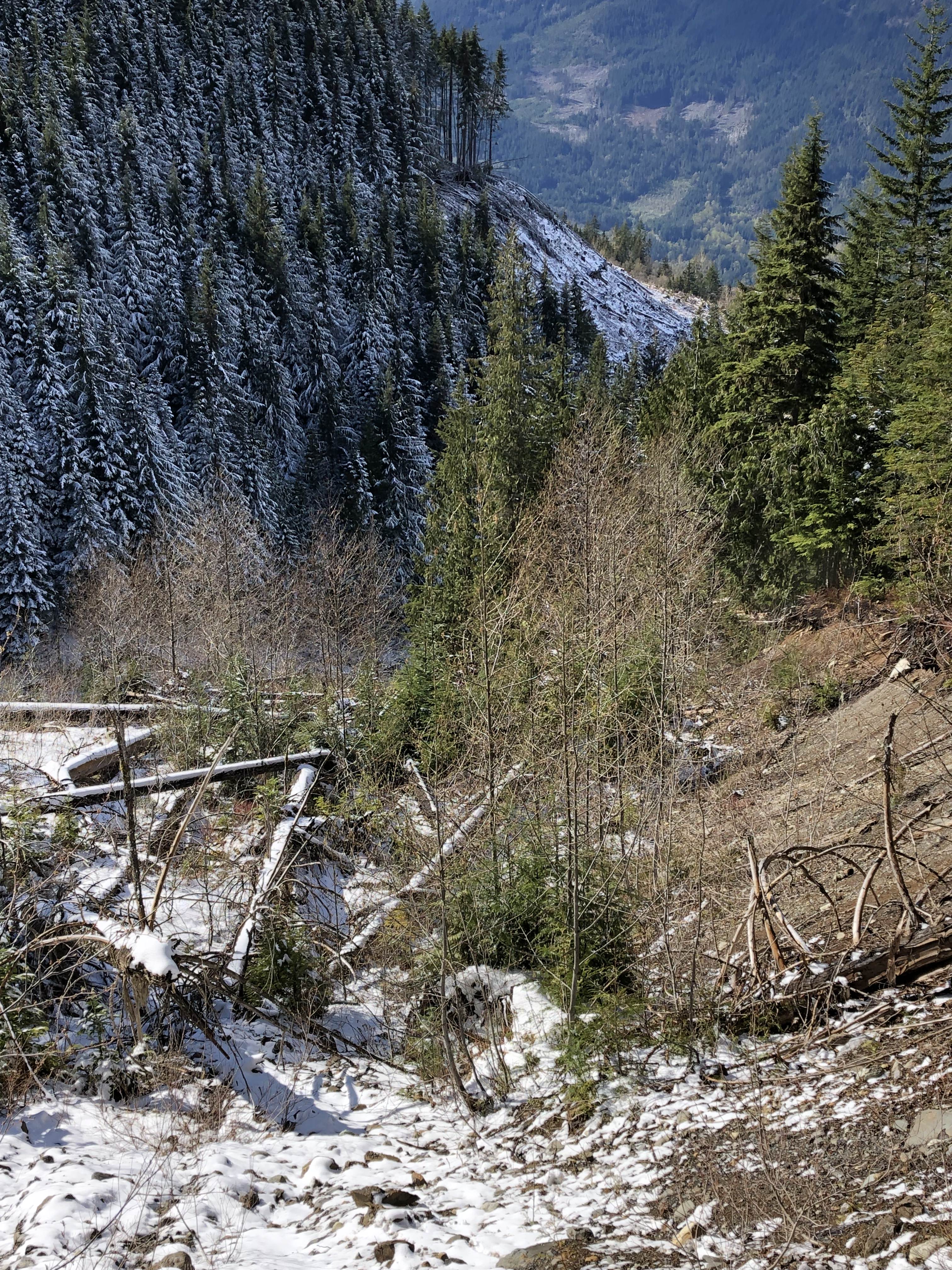
Figure 1: Side of valley decimated by high waters or some other force. Cirque-like feature?
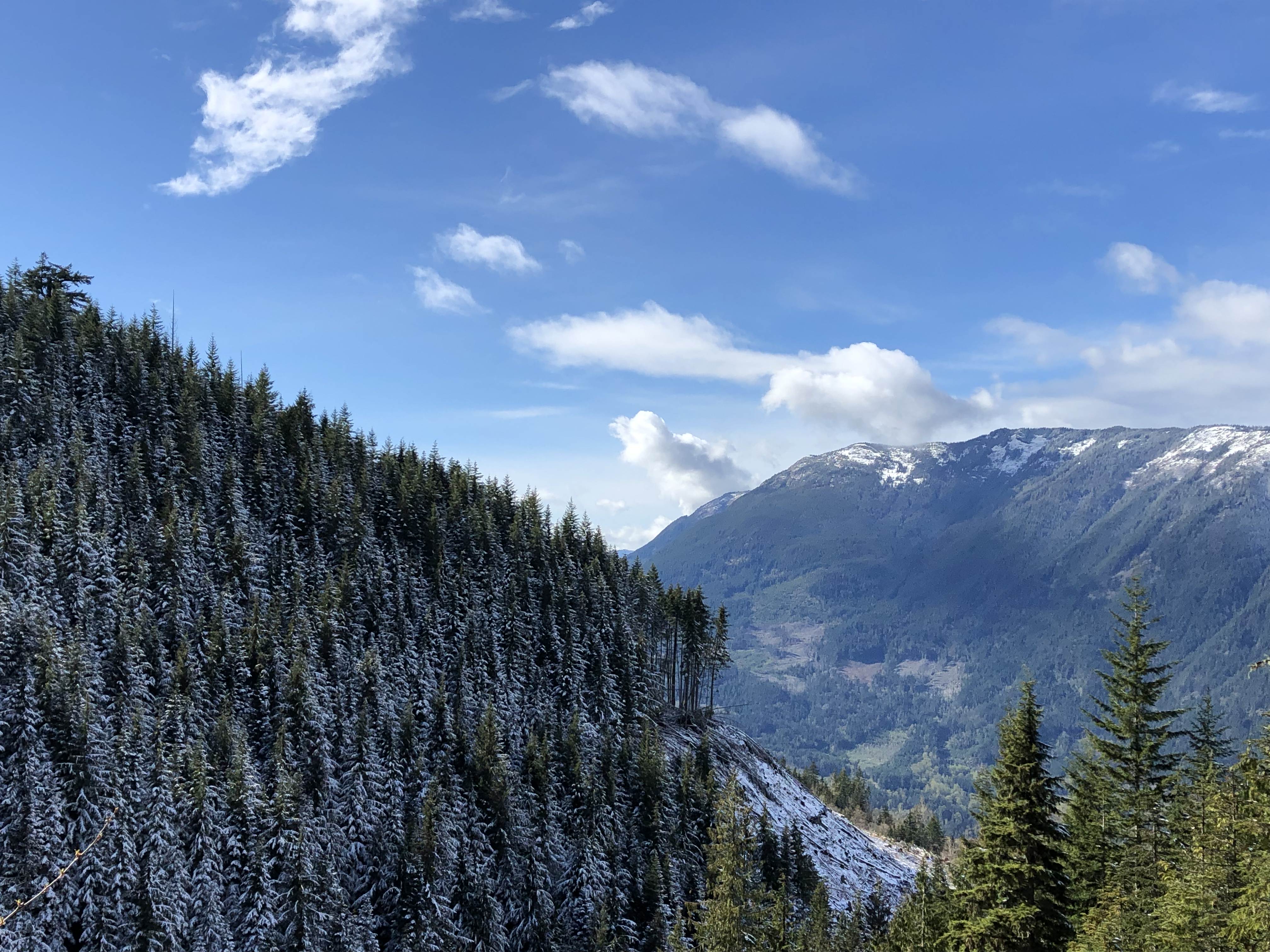
Figure 2: Beautiful view (looking northward) from side of valley as I approach Borden Creek from the east.
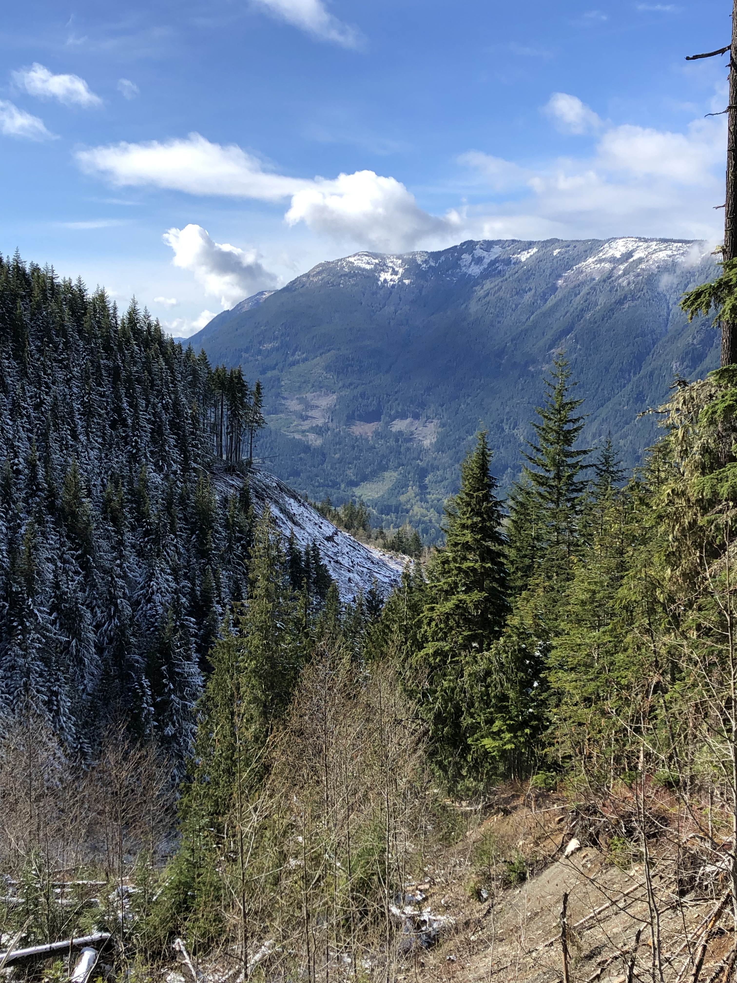
Figure 3: Beautiful view (looking northward) from side of valley as I approach Borden Creek from the east.
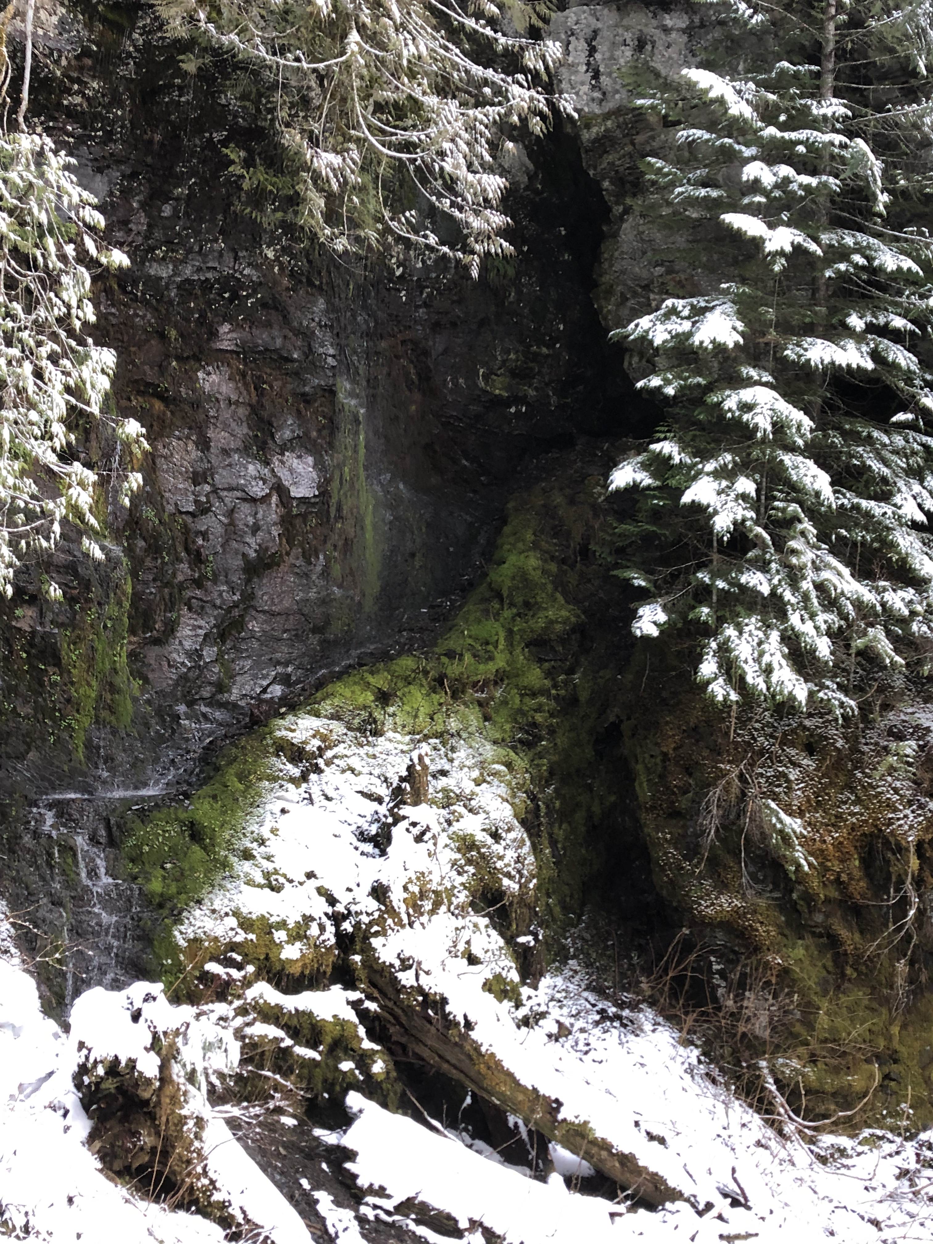
Figure 4: Getting Karsty
After checking out the waterfall and investigating potential leads on the other side of the creek, I realized I was past due to begin the trek back. I high tailed it out of their, back east toward the Slesse-Borden Creek FSR. After crossing over that eroded section, I didn’t follow the route I had come over on. Instead I “bushwhacked” down the plateau where I would connect with the road at a lower point. In this manner, I could avoid some twists and turns, and so long as I pushed down at a good pace, could save time on the journey out. I lost my footing on countless occasions. Soon enough, I encountered what was clearly karst features, suggesting I was honing in on the location of Memorial Day Cave. It also worth noting that I deliberate got off the trail in order that I might also find further clues as to the whereabouts of Memorial Day Cave. The section of forest I was dead-reckoning through was within the area where the entrance to Memorial is found.
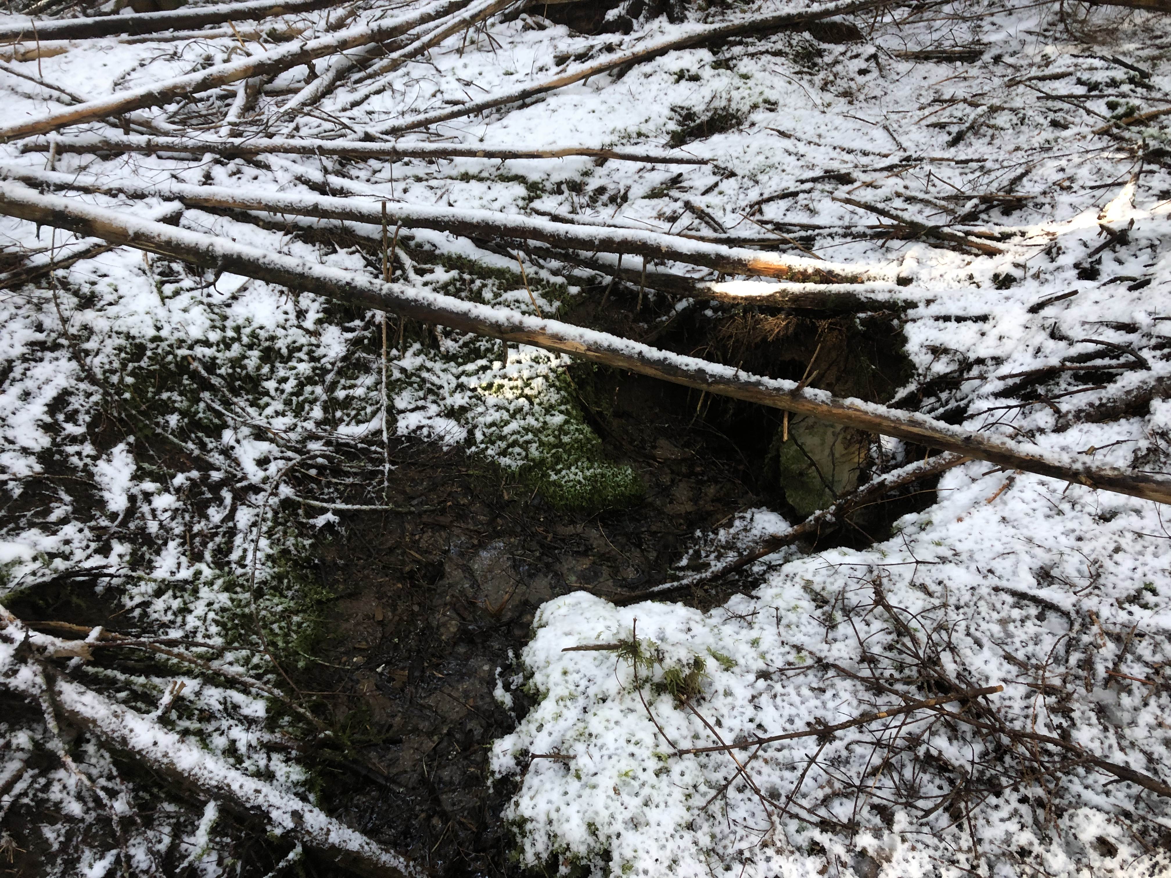
Figure 5: Sinking stream (Karst feature).
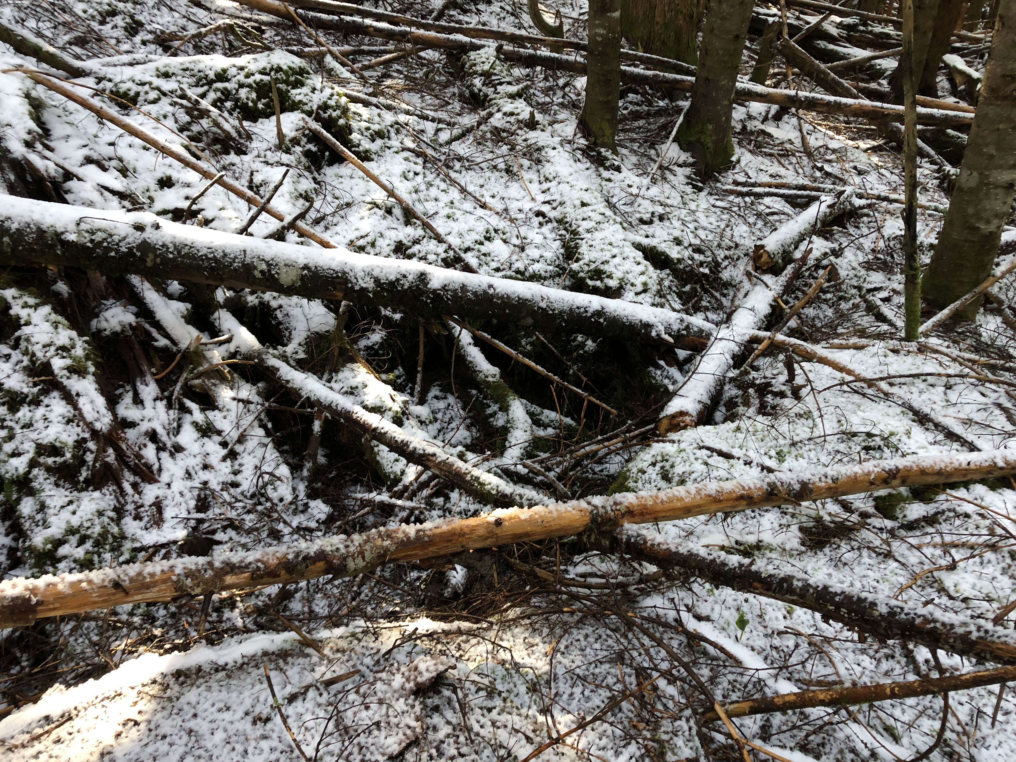
Figure 6: Sink.
I also encountered a large limestone outcrop in this forested patch, which I am certain houses much of Memorial Day cave. This was a fruitful trip, and I am confident that I am honing in on the location. Anyhow, as I continued down the plateau, it was clear that I was cutting it close to my reaching my callout time (the time at which I was to inform my brothers I was okay, otherwise they were to alert the police, who would in turn activate SAR and Cave Rescue). I picked up the pace, and went from a hike to a jog or almost even run. This is surprisingly difficult while carrying a heavy pack, and it was certainly activating an injury in my pelvis due to a car accident in the summer of 2018. My worst fear had materialized, and my callout time came and went, though I was still not through with the hike out. Within minutes I was packing into the Evo and high tailing out of there to get cell access and make the call. No cell access! What the hell? I kept driving to where I knew for certain I would have cell access, as I had access at this area two nights previous. I’ll be damned: for some reason the phone was not registering the mobile service (Telus). It took a reboot before the Telus network could be tapped into. i eventually got in touch with my brothers, and despite nearly a half-hour post callout time, I was delighted to learn that they had not been alarmed, and very cooly decided to give it a few more hours before declaring the situation an emergency. Am I ever glad they decided this! To conclude this adventure, I grabbed a bite to eat at Dancin’ Pizza, a local artisan pizzeria in the valley area. I chatted up one of the workers there, who was quite outgoing, and even managed to convince me to eat the despite having initially decided not to. I am confident that in the next trip, I will be able to hone in on the location of the cave. I have marked appropriate areas of interest, and future investigations will see exploration in these areas. I will report again with my findings. Stay tuned!
Raymond,
Interesting trip report.
I believe that since the washouts on Slesse-Borden people have been accessing McGuire from the roads on its north side but I have and direct experience. I don’t know if that would help access the caves though. In the early to mid 90′s I hiked McGuire several times from Slesse-Borden and did observe a cave. In those days one could drive further than apparently you did. I don’t know if it the cave we saw had a name or if it is one of the ones you refer to. It definitely started out fairly vertical. We were not cavers and did not enter it but did drop a rock down. Based on the geology i’m sure there would be other caves in the area. If you want, email me and I could give you what info I can.
Raymond,
Interesting trip report.
I believe that since the washouts on Slesse-Borden people have been accessing McGuire from the roads on its north side but I have no direct experience. I don’t know if that would help access the caves anyway though. In the early to mid 90′s I hiked McGuire several times from Slesse-Borden and did observe a cave. In those days, one could drive further than apparently you did. I don’t know if it the cave we saw had a name or if it is one of the ones you refer to. It definitely started out fairly vertical. We were not cavers and did not enter it but did drop a rock down. Based on the geology I’m sure there would be other caves in the area. If you want, email me and I could give you what info I can.