Here is the Avalanche Canada report: on the west face of Mt. Pattison, we triggered a size 2 avalanche where all five of us in the team were partially buried. In additional detail to the report, we observed that the depth was ~20cm. After we got up out of the debris, we looked at each other in bewilderment at how lucky we all were to be uninjured. Our top mistakes were immediately clear:
- Assuming spring conditions. We did not consider the recent snowfall combined with warming.
- Not assessing avalanche risk while skinning. For instance, the natural avalanches were seen throughout the day, the W face being warmed by the sun, and the snow quality on the face of Mt. Pattison.
- Traveling up the 35-40deg avalanche exposed slope with all five of us at the same time.
- Being objective-driven/blinded
After a lengthy post-trip discussion and one week of reflection, we wanted to add more to the story. I’m hoping that this trip report will reveal the nuances of what led to the accident, especially with our assumptions and beliefs.
What We Did
Background
Me and Will, and separately MJ and Cha (Charlotte) had a lot of experience touring together, while we met Hana on recent climbing trips. We got connected from planning another VOC ski objective in the Columbia Icefields, but it was the first time that all five of us had toured together. Me and Hana were on splitboards while the rest were on skis. We were all eager and excited to do Spearhead, and for some of us it was the goal since the start of the season. The visibility window had finally cleared up! We thought that it would be a chill time on Spearhead, especially compared to the scarier and more technical objective in Columbia Icefields that we were preparing for prior.
May 18 Pre-trip
Me and Hana were together and rock climbing 5 hours away from home. We didn’t have cell service and were rushing (!) back to catch Spearhead, knowing that 2 days ago, the forecast looked clear. All of us attend the virtual pre-trip meeting at 8PM and we looked over the route plotted by Will and discussed camping, potentially tough navigation spots, and potentially crevassed areas. I asked if anyone wanted to be the leader since I wasn’t the most familiar with the map. But with no one volunteering, we shrugged it. We spoke about potentially nice skiing objectives on the way and agreed to ski them during early mornings. We divided up packing for the tent, stove, and fuel, and made time to meet at 9:15 at Lot 4 Parking since the lift would not open until 10AM.

Things were looking even better for visibility (more sun) than this 2-day old snippet here.
May 19 Resort to Decker
Cha and MJ did the sun dance to invite good spirits and visibility. Stoke was high. Hana was carrying the biggest, heaviest bag and still bouncing on her feet towards the resort. We loaded on Blackcomb Express at 11AM, slightly later than anticipated due to repacking and forgetting things in the car.
At the bottom of the Showcase T-bar, the hill to skin up to enter Glacier Bowl was closed off. Others in the group talked to the ski patrol who said that we were not allowed in the area – something about avalanche risk management. Cha and MJ talked to ski patrol for a couple more minutes while the rest of us itched to get started. What a nuisance it was that now we’d have to go back up Jersey Cream Express, traverse down to the bottom of 7th Heaven Chair, climb on top of Diseased Ridge, to enter the backcountry.
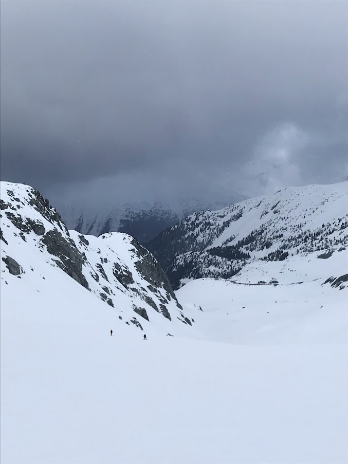
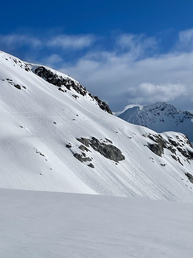
We descended a little down to 7th Heaven and the snow felt like heavenly powder. The clouds were lifting higher and everyone was in good spirits. The uphill exercise to Diseased Ridge pounded on and MJ took charge. Who ever made this path really didn’t like switchbacks said Will. At 1PM at the corner of Diseased Ridge, Will and I were at the back of the group when I pointed it out to him, look at all the pinwheels. Globs of snow resembling wheels were rolling down from the mountain actively, and small point avalanches were seen far away. We pressed on, let’s catch up to the group. After this point there were no more premade skin tracks for us to follow.

Ascending up Diseased Ridge. Thin fog was weaving in and out.
First fall of the day as I try split ski that weighted pack.
(Two above) Skiing and split skiing the ups and downs to get across the high side of Body Bag Bowl.
May 19 Decker Lake to Trorey Glacier
At 3PM on top of the lip before descending down to Decker Lake, we stopped for a long overdue lunch. It was our first time collecting as a group since we started from the bottom of 7th Heaven chair. We discussed where we wanted to go loosely. I vouched for going for the north shoulder of Decker instead of directly walking on the west face up Decker Glacier, which were both standard routes. Pros is it may be less tiring than the big uphill, con was that it was a new route to all of us. The shoulder looks like kind of a steep traverse… But oh well let’s see up close.
The traverse on the west of the shoulder leading up to the turning point was where most of us got bad gut feelings. This seems a little sketchy. Will gets stuck at a lower point and powers through an exposed section of the traverse. The rest of the group goes along, and things don’t look any mellower. Are we sure this is the right path? Hana opens up the map on her phone, it was the official FATMAP plot titled <The Spearhead Traverse: A Whistler Backcountry Classic>. It seems like we’re on track. None of us had this path plotted out since we only had the Decker Glacier option.
Right before the shoulder we were stuck at a bad spot and had varying opinions on whether we should transition to downhill. We did since it seemed safer to do so just to get around the shoulder.
After U-turning at the shoulder, we grouped up only momentarily, only to transition to uphill. Our group was more disjointed now with Cha breaking the trail. On the east side of the shoulder it didn’t seem like the right path, but we couldn’t go down anymore since there was an unknown lip and rocks. We regrouped, figured out we were back on the official FATMAP plot, so let’s follow it. I took the lead for a bit until I felt like I was in a bad spot. Will was urging us to transition and drop down. The light was flat now at 5:30PM and we couldn’t see how far down was down. It should all be the same, let’s transition and we just walk straight to the bottom of Pattison said Will through the walkie-talkie. Hana had the map loaded and she wanted to continue on the track. So in an attempt to keep one foot in front of the other and to get out of the steep traverse onto safe, flat ground, we split up. Will and I descended down, while Hana led the rest along the FATMAP plot.
On the 45deg downhill we released some 1m long wet-loose slides. It looked like a graveyard of point avalanches size 1-1.5 near the peaks around us and my bad gut feelings increased. Ascending up Trorey glacier was a slog.
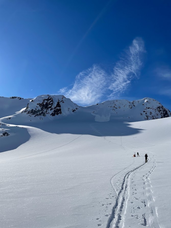
MJ and Hana led the way on the glacier, Cha as buffer, Will and I were catching up from the valley. Just before the bottom of Mt. Pattison Cha asked MJ and Hana to wait for others as it’s a decision-making point. She explained to the girls her view on thevery loaded, convex and wind affected slope on the left side of the rocks and insisted on not taking this option despite the FATMAP plot data.
We met up with the rest of the group waiting at the bottom of Mt. Pattison at 7PM. They had been waiting for more than 10 minutes since our path took longer and Will was dehydrated. I felt behind on schedule since we wanted to get all the way to the end of Tremor Glacier for camp. On the upside there was at least 2 more hours of daylight!
On top of Decker Lake heading towards the west face of Decker shoulder.
Will and I descend separately from the east side of the Decker shoulder traverse.

MJ and Hana walking up Trorey Glacier. The light was flat and dreary.
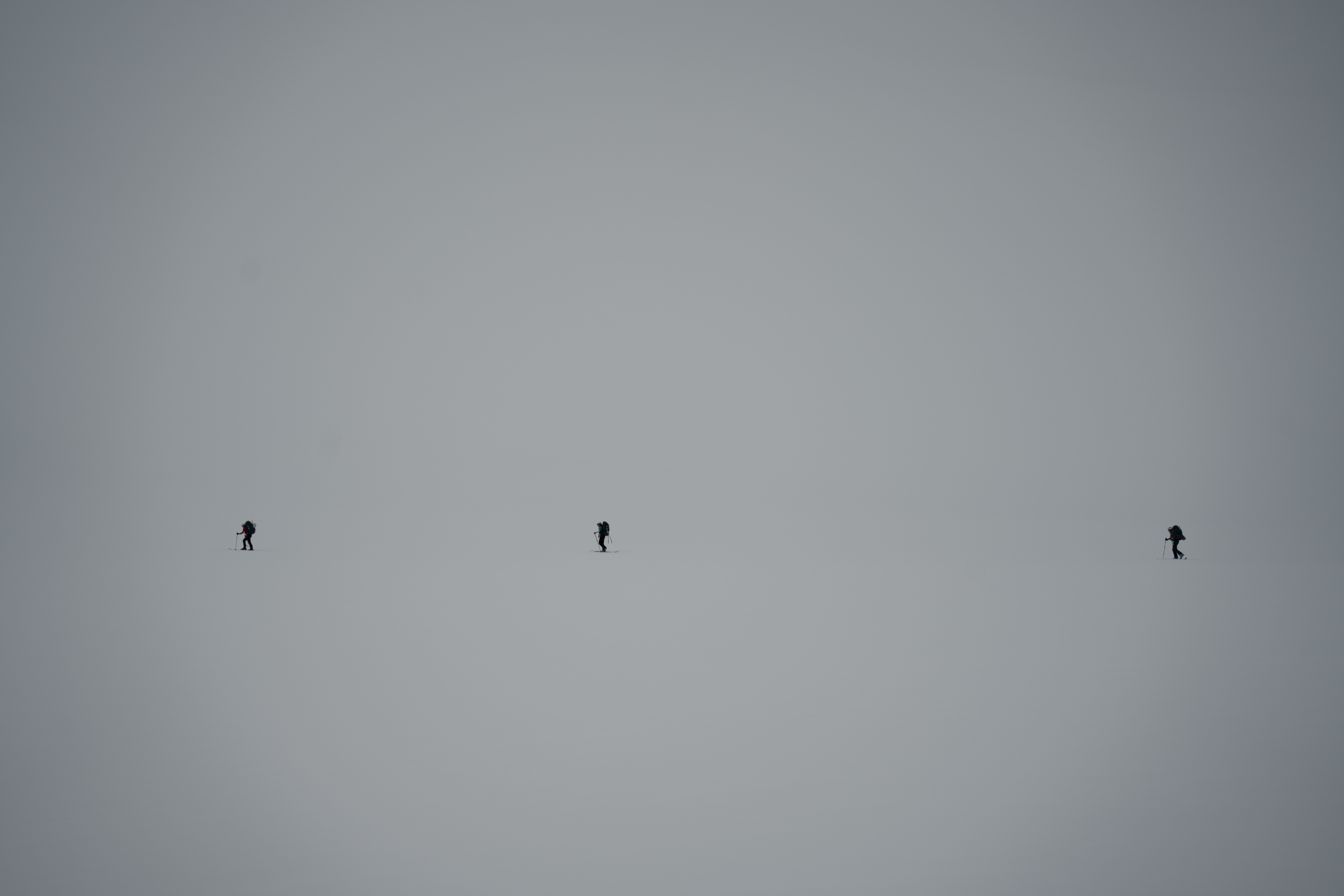
More walking in flat light.
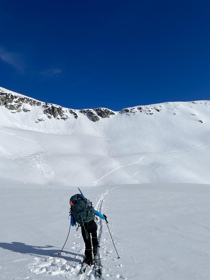
May 19 Trorey Glacier to Mt. Pattison
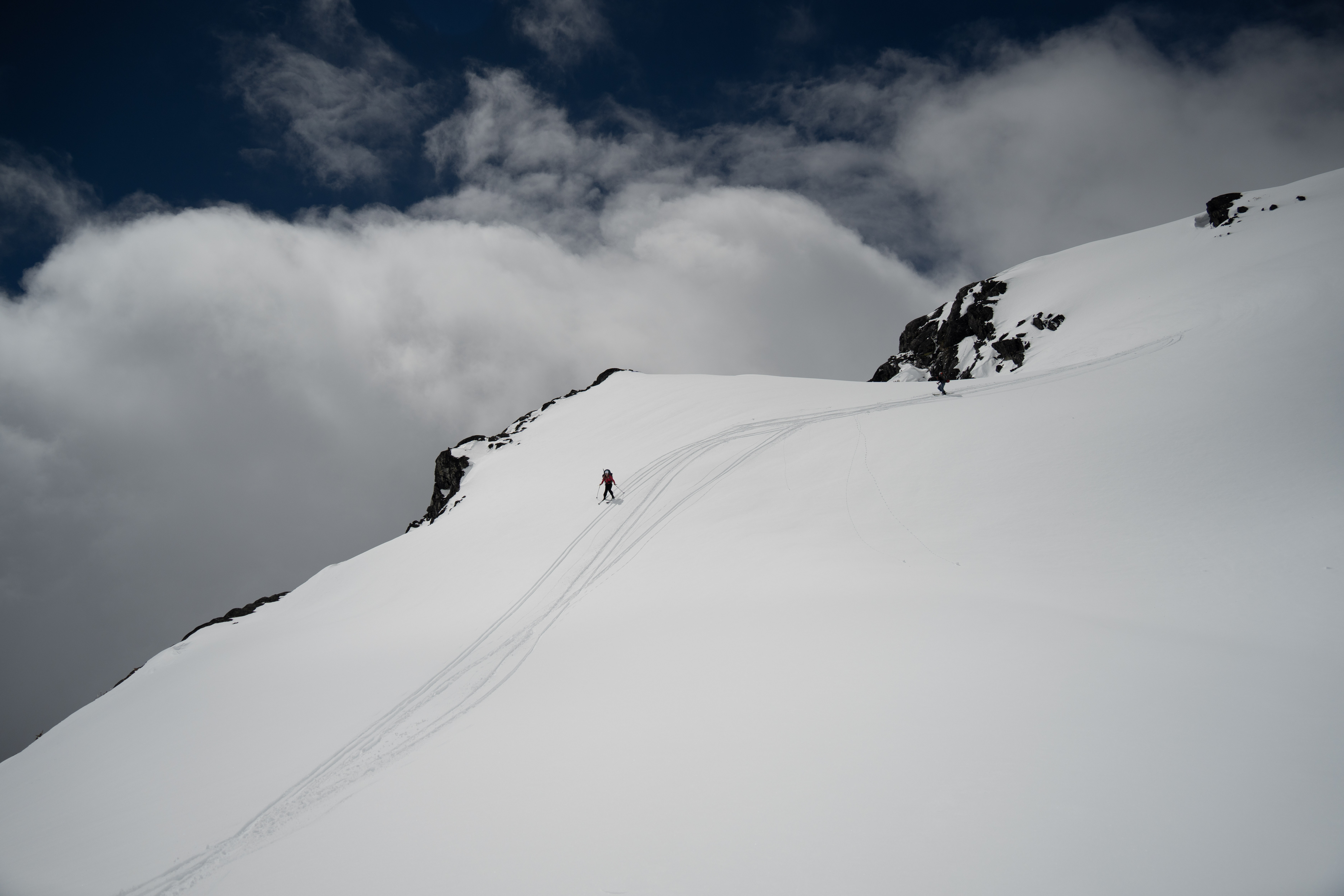
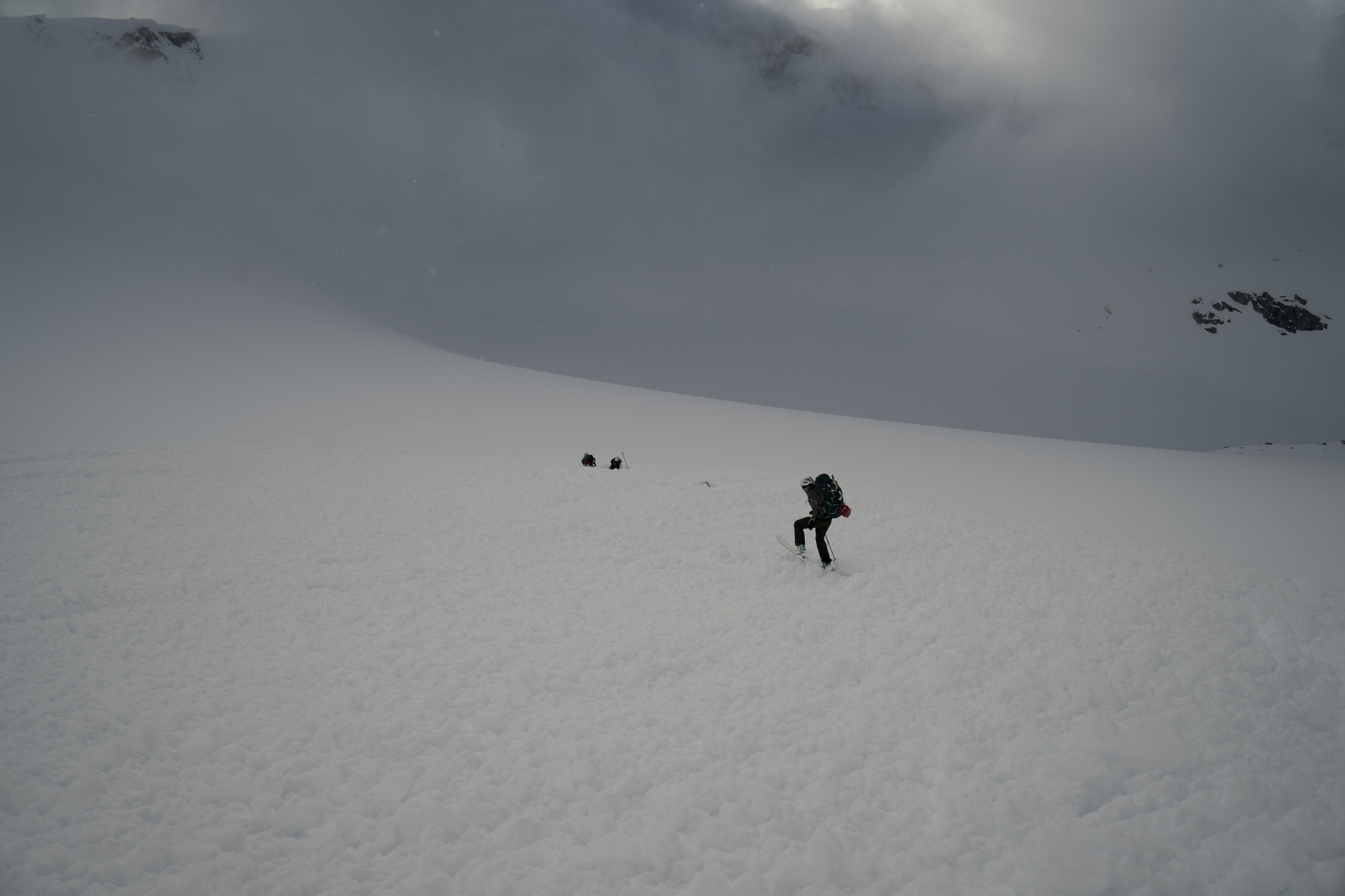
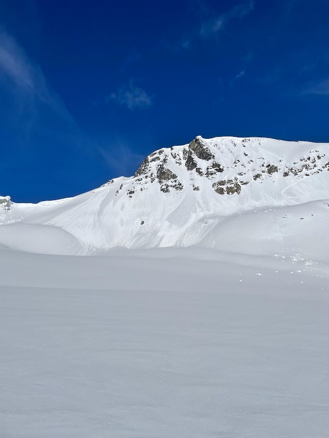
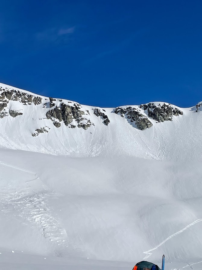
Looking up at the west face of Mt. Pattison, we deliberated about the uphill path since it was clearly technical. Where to kickturn so that we can avoid the steepest parts? Keep the right side of the rock as long as possible and traverse left just before the col. MJ had a good plan and Cha directed suggestions from the backside (which kept the group very close together). We coordinated as a group a bit better, thankful that we were all traveling together now. We were spaced 2m apart on the skin up with MJ breaking the path. Hana and I comment on how incredibly powery it was, this will be fun to ski tomorrow! Cha suggests to traverse now asupper looks too steep andmore loaded, so her and Will branch off 2m below MJ, me, and Hana. Then it happens.
Cha’s perspective: Will in the front, making one step after the other very carefully as it was not looking very stable anymore. It felt wrong which I share with him as it’s exactly the slope I wanted to avoid…and it happened very quickly! I saw Will sliding more than usual and felt the ground breaking up under my feet, not able to control anything anymore. I understood directly what it was about and the direct consequences. Unconsciously, I screamed in French: Ah non, non, non…pas maintenant…pas comme ça! I was not ready to die this way, and I believe that no one was. The snow was pushing from the back and my legs started to sink. It felt very heavy, the motion was fast and felt a bit like river rapides. Hopefully I stayed quite at the surface. I dropped my poles and tried to keep my arms up. I heard MJ on my side commenting everything in a very rational way, it’s an avalanche…it’s accelerating…it’s decelerating…it stopped. It helped me a lot to understand that indeed it stopped and we were not moving anymore, which my body didn’t assimilate yet, still absorbed by all the sliding sensations. I counted loud all the heads. I could see in front of me: 1 (MJ), 2 (Jenny)…turned the head: 3 (Will)…but Hana’s head was missing. Thankfully I heard her yelling and thought: Hallelujah, she can breathe. I was buried until my chest but with free arms. It took me more time than Jenny, MJ and Will to get out of the snow, my backpack still on the shoulders but partially buried as well. Found one pole next to me and didn’t care about the second one lost in the avalanche. I joined Jenny and MJ for the last effort to get Hana out. I realized very fast how lucky we were and was happy to give and get some love through a big hug with Hana and Jenny. VIVE LA VIE <3
Post-accident: I didn’t sleep at all the following night in the tent on the glacier, trying to think of the safest way to get out and bombarded myself with 1000 existential questions. I felt good the following day, ready to tackle our way back. My body and mind were keeping up but once home, all the pressure relieved and I literally collapsed! The following 2 nights I woke up in the middle of the night crying, not remembering any dreams, just crying. As well, I had (and still have, one week later) the feeling that my nervous system broke down. I’m not feeling any pressure from any sources of potential stress as work, time constraints, things that would need to be done…I don’t care and notion of time is a bit more relative! As well, making choices of any type was very hard this week and I’m finding myself way more evasive. I’m just accepting and laugh about it, body and brain are funny!
Will’s perspective: In the front, trying to get to the entrance of Tremor Glacier ASAP. Really tired and dehydrated so my brain wasn’t thinking much. At the front, I was trying to prepare every step. The snow below my feet occasionally shifts a little, it was sketchy but I just wanted to make it to the col cus it was just 30 meters ahead. Out of nowhere, a small block of snow started to shift under my feet, the first second I thought it was just a little bit of snow movement. But a couple seconds later, I heard a gasp from the girls behind me, and the next thing was all the snow around me started to slide with almost like a thunder noise. It felt quick and slow at the same time. Quick as in you are in shock, and there was no time to check around to see (if other people were in it/ how much snow was coming). Slow as in the snow blocks needs time to pick up speed. The first 5 seconds, I was on top of the snowpack, snow went up to around my waist, I was able to think and I was calm. Then it starts to pick up speed, and snow starts to crumble and snow underneath rises up. My face was covered at one point, and all I remember was to SWIM. I poke my hand out, trying to do a frog style stroke and it worked. My hands felt the air and I was able to push the snow behind me. 5 more seconds of swimming and it luckily stopped. I was buried up to my chest and it took me around 3 mins to free myself. Phew !
MJ’s perspective: First thing I noticed was like “Oh, the ground is sliding down and it’s all of us not just me slipping.” And very quickly it was like ok, this is an avalanche. As we slid I was sitting kind of with my feet in front of me and arms at my sides. I remember thinking (and then saying out loud cause I don’t know, I narrate when I’m nervous I guess) that we just have to stay on the surface and that I was in fact still well on the surface and I was looking at the others and they were pretty much all on the surface too, all shouting various things, so that was good. I did notice that we were speeding up, so not good, but on the surface, so good. Then we started slowing down and I’m pretty sure I yelled “we’re slowing down! We’re gonna be fine!” then we stopped and it was quite hard to move though my hands were free. I could see Will, Cha, and Jenny really well and it was like “ok they’re good” then, I saw Hana’s hand sticking out, she was waving and yelling “I’m over here!” which had to have been the best thing she could do since it made it easy for us to get to, find, then dig her out. I used my free hands to unburry myself (in up to about my waste) and I popped off my skis and ran over to Hana, Jenny already had her pretty well uncovered, so I got out my shovel and un-buried her bag and split skis/bindings so that she could fully get out. No one was injured, like at all, so that was really quite lucky.
Jenny’s perspective: First I feel the ground coming out below me. Followed by the booming crack of thunder travelling above and across me. I start to slide at the rate of a fast walk. I’m turned to my right side as I slide on my back and I see MJ and Cha. Things seem rather calm as we’re managing ourselves to stay ontop of the slide. I hear MJ narrating. The slide feels excruciatingly long. I constantly check in on whether I should release my pole but since I didn’t feel like they were sucking me down, I hold onto them. Just as the slide below me speeds up and starts to cover my knees, and inching up to my waist, it comes to a stop at my chest. My hands are free and I’m in a rather comfortable seat. Everyone’s voice pipes up around me saying their okay and I take a moment to sigh in great relief before uncovering myself.
Hana’s perspective: I’m at the back of the group after Will and Charlotte cut a skin track to the left to meet up with MJ in the front. The snow feels deep and powdery. Almost too powdery. I’m focusing on getting one foot in front of the other. Then, almost in slow motion, I start to feel my feet sliding out from under me. I hear an awful, booming, thunderclap. The ground shakes me off balance in what feels like an earthquake. When I look ahead, it seems like the mountains are moving – but – that doesn’t make any sense? No.The mountains aren’t moving upwards – we’re sliding downwards. The slide starts gradually, sweeping my feet out from under me and pushing me forward. As the avalanche picks up speed, I lose sight of the rest of the group as I start to get sucked down further and am whisked away from the others. I can feel my board and heavy pack pulling me deeper and deeper into the snow. The snow goes up to my waist, then my chest, then up around my neck. I struggle to push whatever I can away from my face. I start to panic. In a matter of seconds, the snow will be over my head. “I’m going to suffocate” I think… Then, just as quickly as it started, it slows, and lurches to a halt. A giant block of snow is balanced just above me. If the slide had run only a few more metres, I would have been a full burial. My mind is racing “holy shit” I think… “I should be dead”. As the snow stops, it solidifies. I’m entombed in what feels like cement. I’m buried up to my neck. All I have is my face and one hand free. I yell and wave frantically. Relief floods my body when I finally see Jenny’s face peek over the snow. “We’re going to be ok”.
Back to Jenny’s perspective: I dig myself out and run 10-15 steps to Hana. She’s looking like she’s having a bad time but is talking alright. The snow is up to her chin and the rest of her is beneath the snow except for a free forearm with a pole. She’s turned around somehow with her back down hill. I’m going to get you out as I frantically use my hands to dig her out. The snow is soft enough to do so but heavy with moisture. The rest of the group comes to aid.
Everyone is uninjured right? I think my knee is hurt. Should we call SAR? My knee is okay actually. We’re not in an emergency and it’ll be hours and dark before they come. Can they even fly in at night? We should make camp. I’m going to recover my pole. We should report this. Where should we camp?
Will and I had Fido plans and got enough phone signal to call 911. He explained the accident and gave our GPS coordinates. We were asked to wait for an upcoming call from the SAR but we lost the signal easily.
We make camp on a flat enough safe spot, far enough away below the rocky face of Mt. Pattison peak. We agree on waking up 5:30AM to travel while its firm. Cha and Will make up a plan to get us out of here.
Me descending up to the rest of the group below Mt. Pattison. Will is behind on the right.
Cha getting herself up out of the avalanche debris.
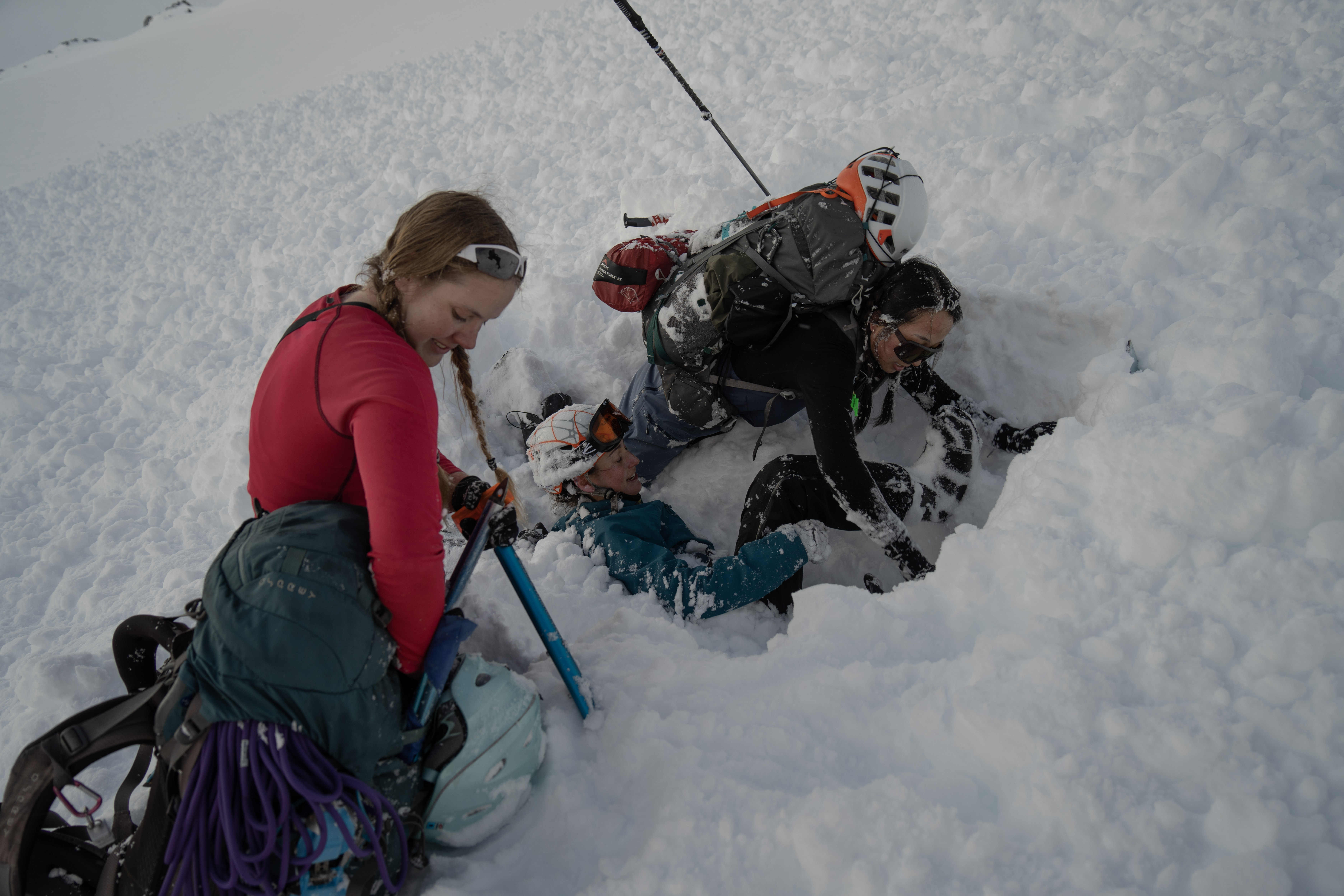
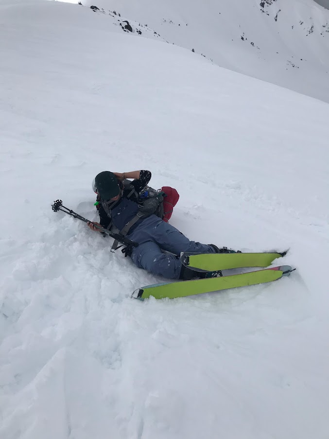
I use my hands to dig Hana out. MJ assembles her shovel.

Cha and I hug a shaken and shaking Hana after she’s out. MJ pulling out Hana’s very large and very stuck pack. The sky starts to clear up for the first time of the day.
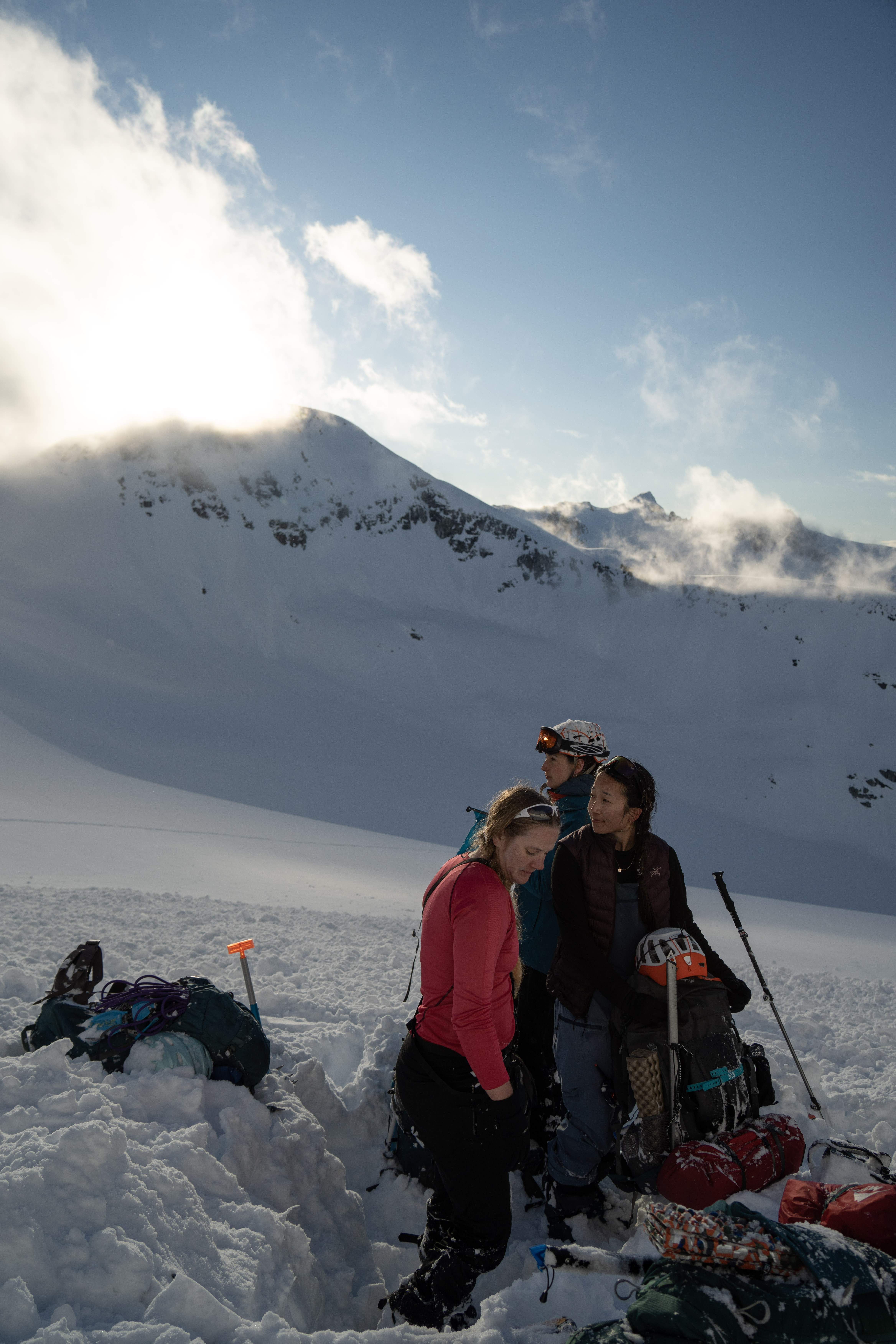
Deciding where to make camp.
Will goes out to look for his poles and finds both of them. Cha sacrifices one pole for our lucky stars.
The sun sets epically over the avalanche debris.
May 20 Trorey Glacier to Decker Lake
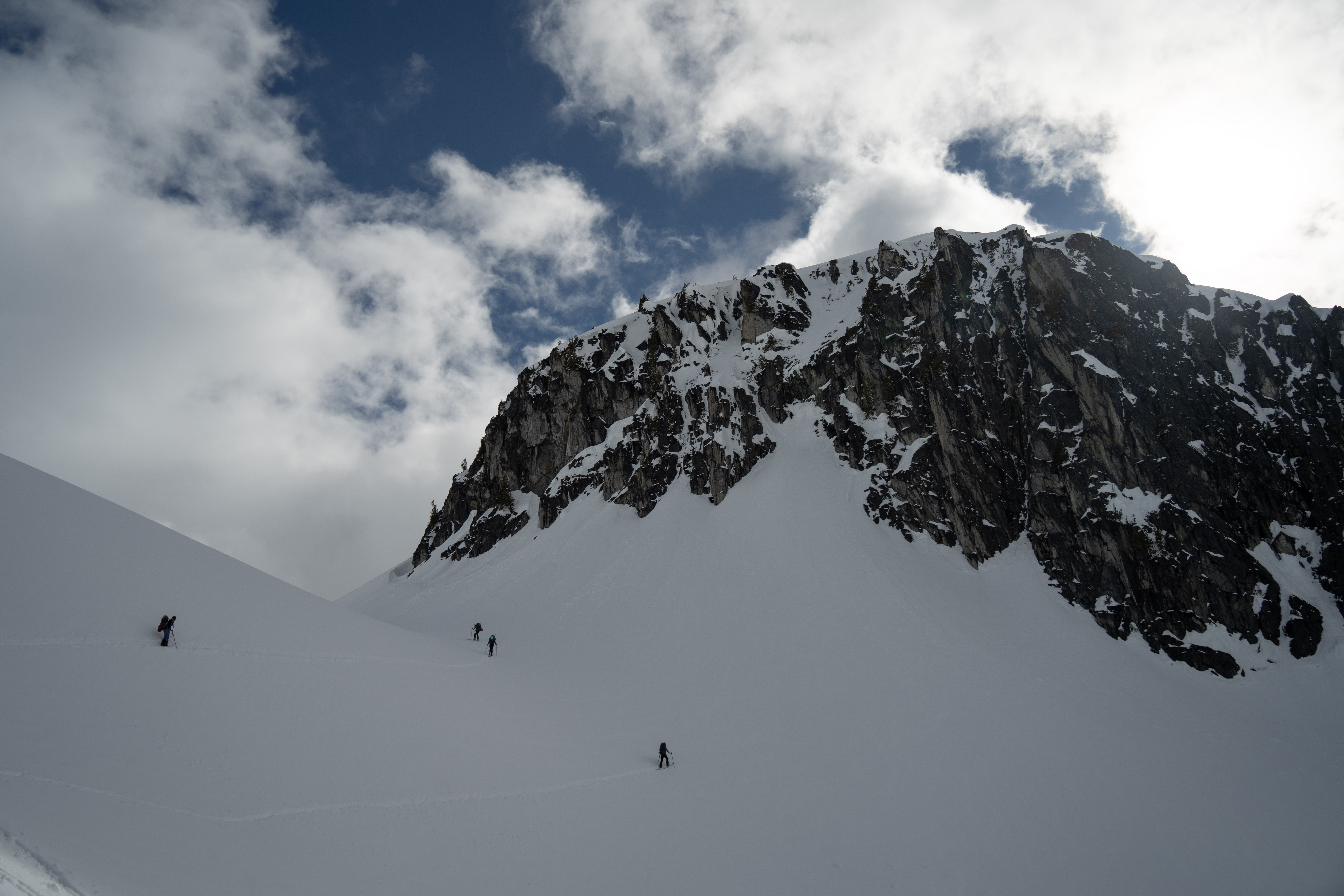
Starting at 7AM we follow our skin tracks back. We make the sketchy traverse along the shoulder but this time it feels safe enough as it’s firm. Ski crampons were much appreciated here, but Will did it without. At the turn around the shoulder we opt to drop down below Decker Lake to avoid the steep west side traverse of yesterday. We feel the sun is heating up, and the snow was already starting to feel wet and loose. Our group behaviour transformed immensely compared to before the avalanche. We were travelling as a coordinated group by grouping up, spacing out, and checking in on each other as needed. This also meant that we were travelling slower.
It was 9:30AM before ascending up to Decker Lake when we decided that the risk wasn’t worth it. The same bad gut feeling itched at us and most in the group wanted to get out of here. Even if we camped here and made our way out early tomorrow, it may be the same story on repeat. The forecast was showing even more sun on May 21. Should we travel at 2am? Will we get picked up even if this isn’t an emergency? We decided to eat up our pride and press the SOS button on my Garmin InReach. We were spooked by yesterday.
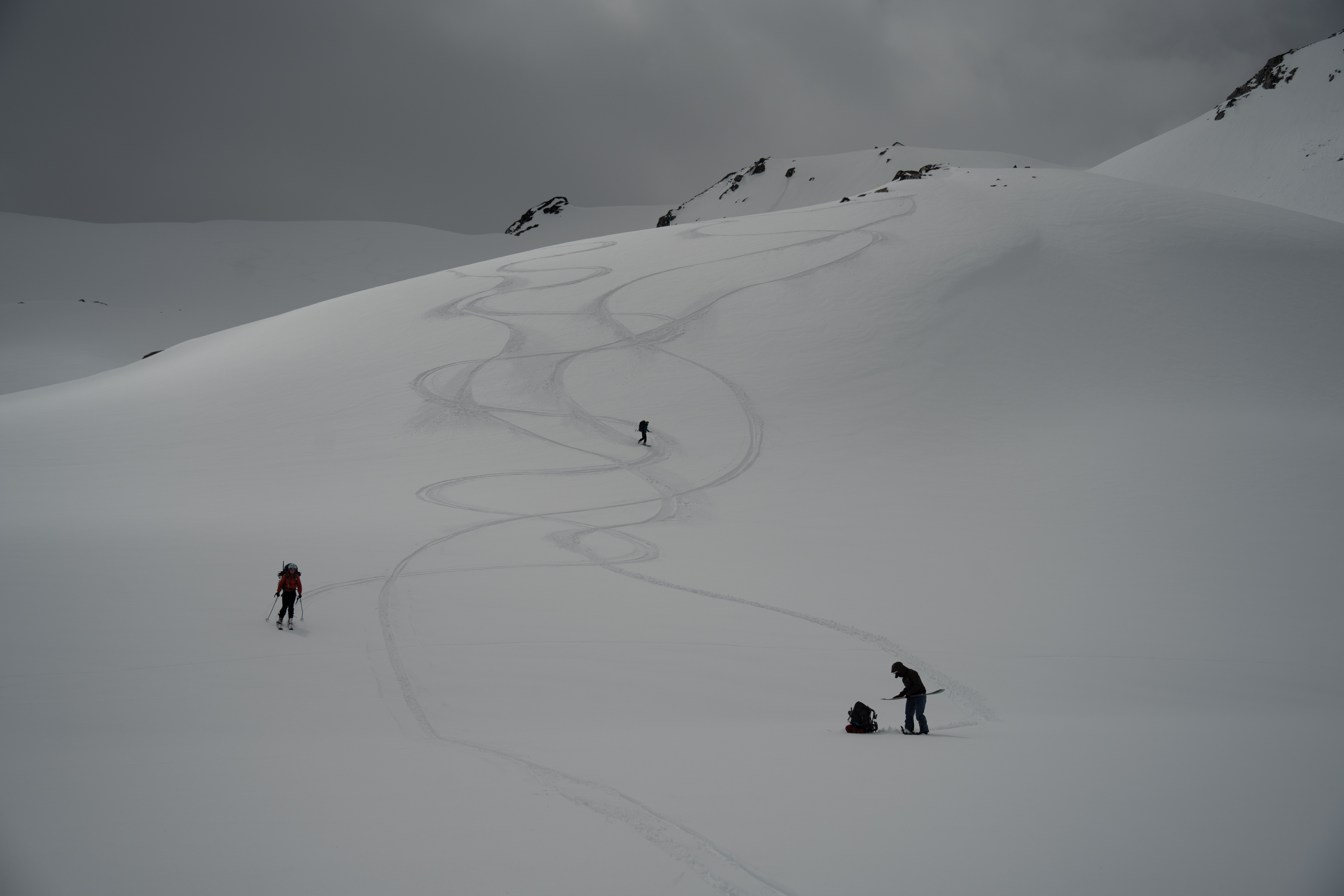
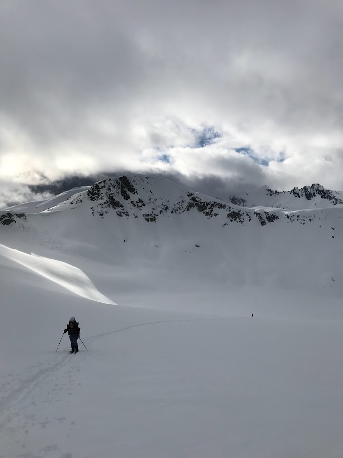
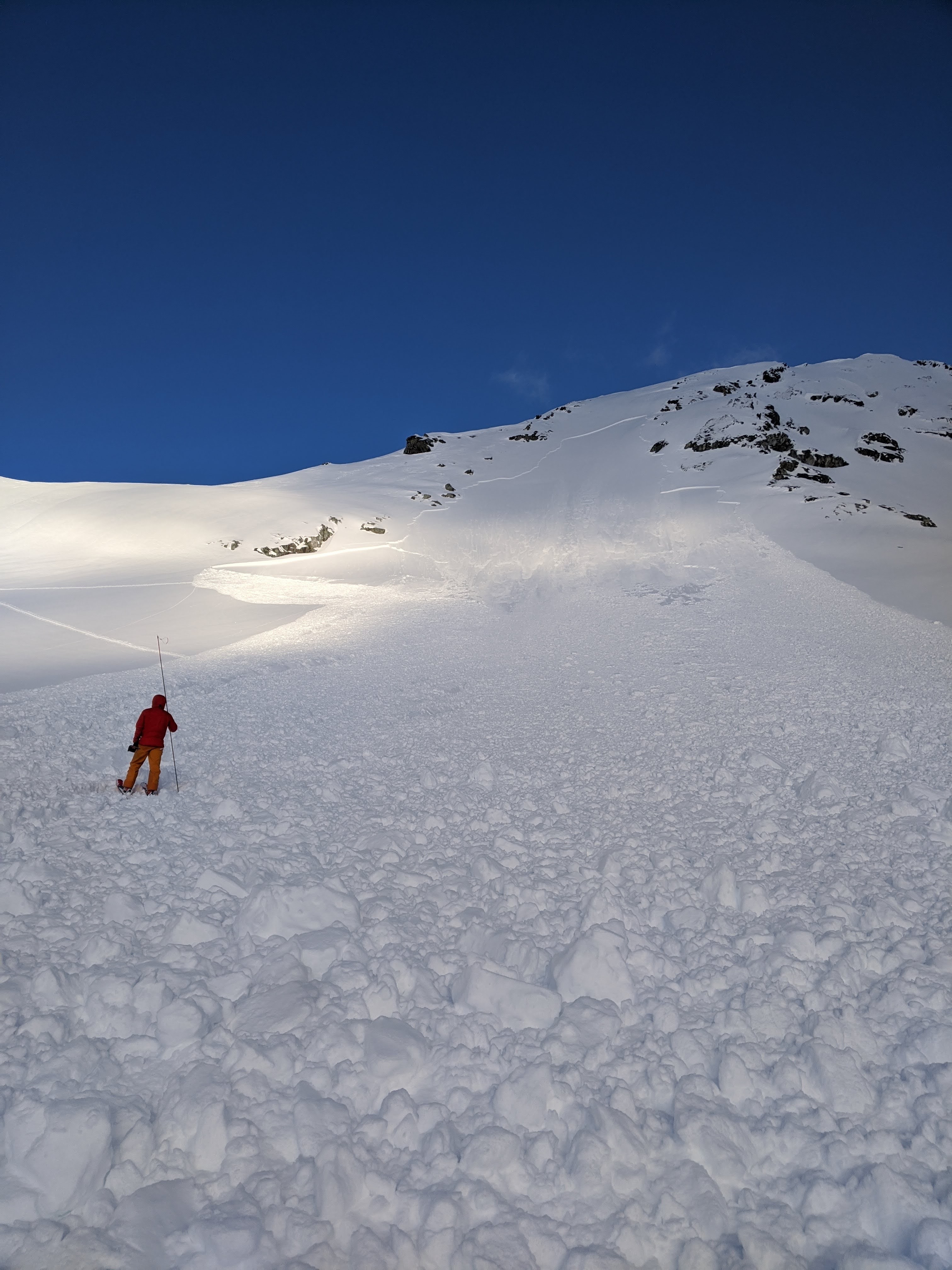
IMG_9511 From Trorey Glacier looking back at the avalanche. We made camp at the base of the rocky ridge right side to Pattison. It was much sunnier on day 2.
MJ ahead retracing our skin track on Trorey Glacier.
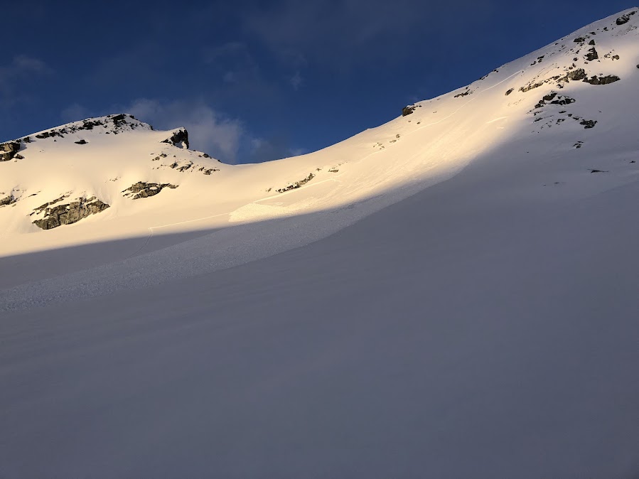
From Trorey Glacier looking south at the many natural point avalanches from the day before.
More natural avalanches looking west.
Looking east towards the east side of Decker shoulder. Me and Will’s descent tracks on the lower right, and the rest of the group’s skin tracks on the higher left. We were lucky that it didn’t shed while we crossed.
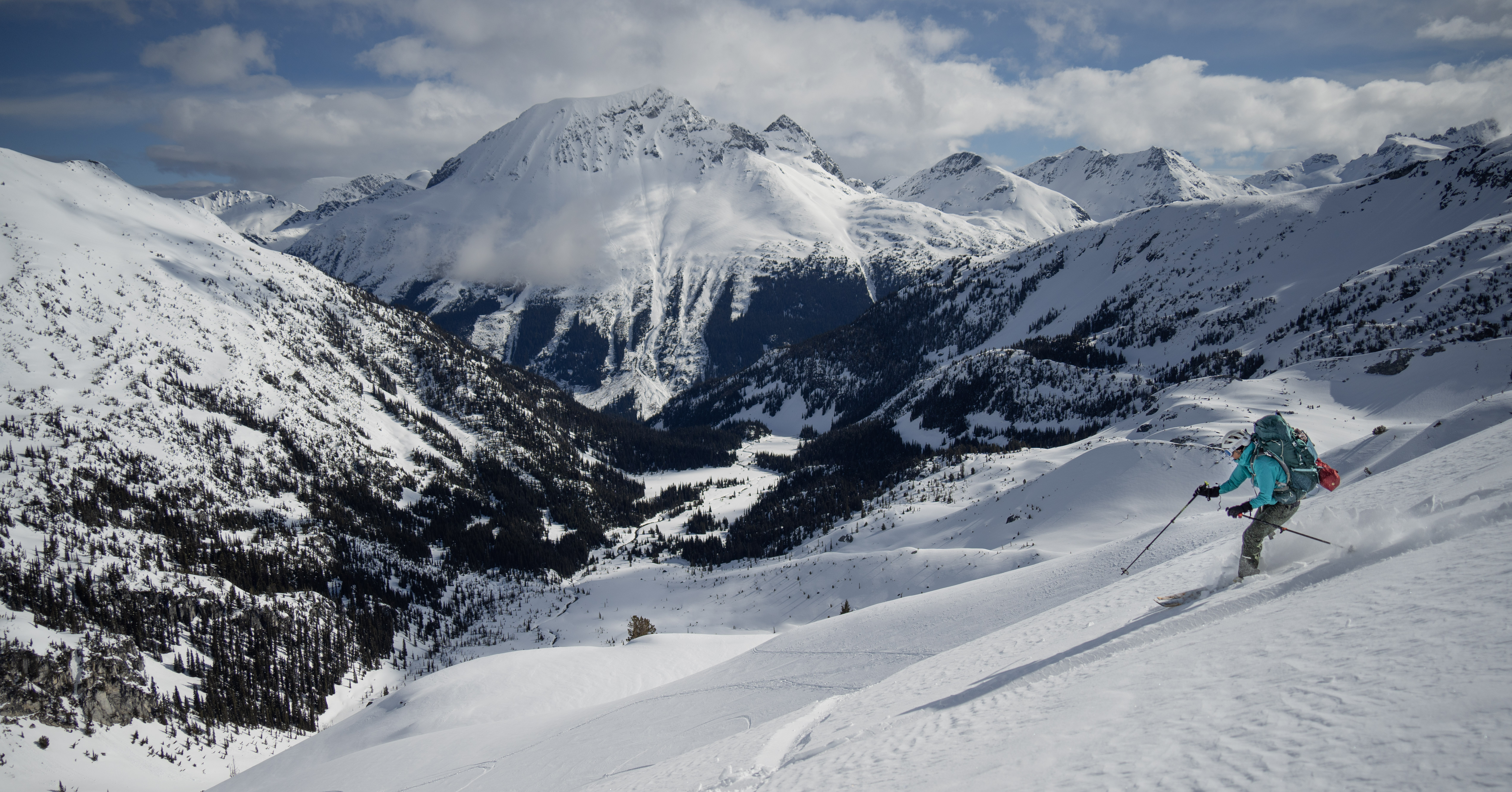
Cha (safely) shredding towards the lower side of Decker Lake.
May 20 Rescue
We safely descend to a safe spot at the base of the hill near the creek and trees. I use my phone to type out the messages via the Earthmate app Bluetooth paired to the InReach. You can also use the InReach itself to type but doing so would take ages as it only has 4 arrow buttons. I am on the basic Freedom Safety plan. Below is the detailed rescue process:
After pressing SOS for 20 seconds and confirming, this was the first automated message.
My message: I have an emergency, and I need you to send help. SOS: inReach Mini, v2.80 (388665), Button Press
IERCC: This is the IERCC, what is your emergency?
This is the central call center based out of Texas.
Group of 5 on spearhead traverse. We triggered a size 2-2.5 avi yesterday but one buried to the neck, no injuries at 50.065, -122.8275. Today we made it to 50.07735,-122.83591 and feel trapped in avi terrain. We want to stop traveling and await for rescue.
Confirmed. Is any one injured?
No one is injured. We will get to a safe spot in the valley. We do not want to make the same mistake as yesterday by continuing to travel.
We have contacted emergency services and they are working on a plan of action to get to your location. Emergency services have asked for you to stay stationary. Is your current location a safe spot?
We have moved to a safe spot where we will wait. Will stay at 50.08161, -122.83158
Confirmed. We will update emergency services. What are the names and ages of everyone in your party?
I send them the info but for the sake of privacy, I won’t include here.
Confirmed. Does anyone have any medical conditions or allergies emergency services need to be aware of?
Only MJ has a peanut allergy.
Confirmed. Do you have food, water and shelter?
Yes we have water, food for 1 more day, and shelter with 3 season tents.
Confirmed.
The above exchange takes place over the 1hr 15mins from when the SOS was sent. My two emergency contacts connected to my Garmin account got a call from IERCC 1hr after SOS, where they were told that I was getting rescued out, but we were all doing okay. The IERCC in Texas contacts the local RCMP about our service needs since it is their jurisdiction. Then RCMP contacts Whistler SAR and a volunteer team is dispatched. After pressing SOS, the location of the InReach is constantly pinging to IERCC, and only stops when you manually stop the SOS after the rescue. At times I had to walk around and slowly wave the InReach towards the sky to get the message received or sent. The sky was relatively clear with ~20% clouds, and on clear terrain with no trees.
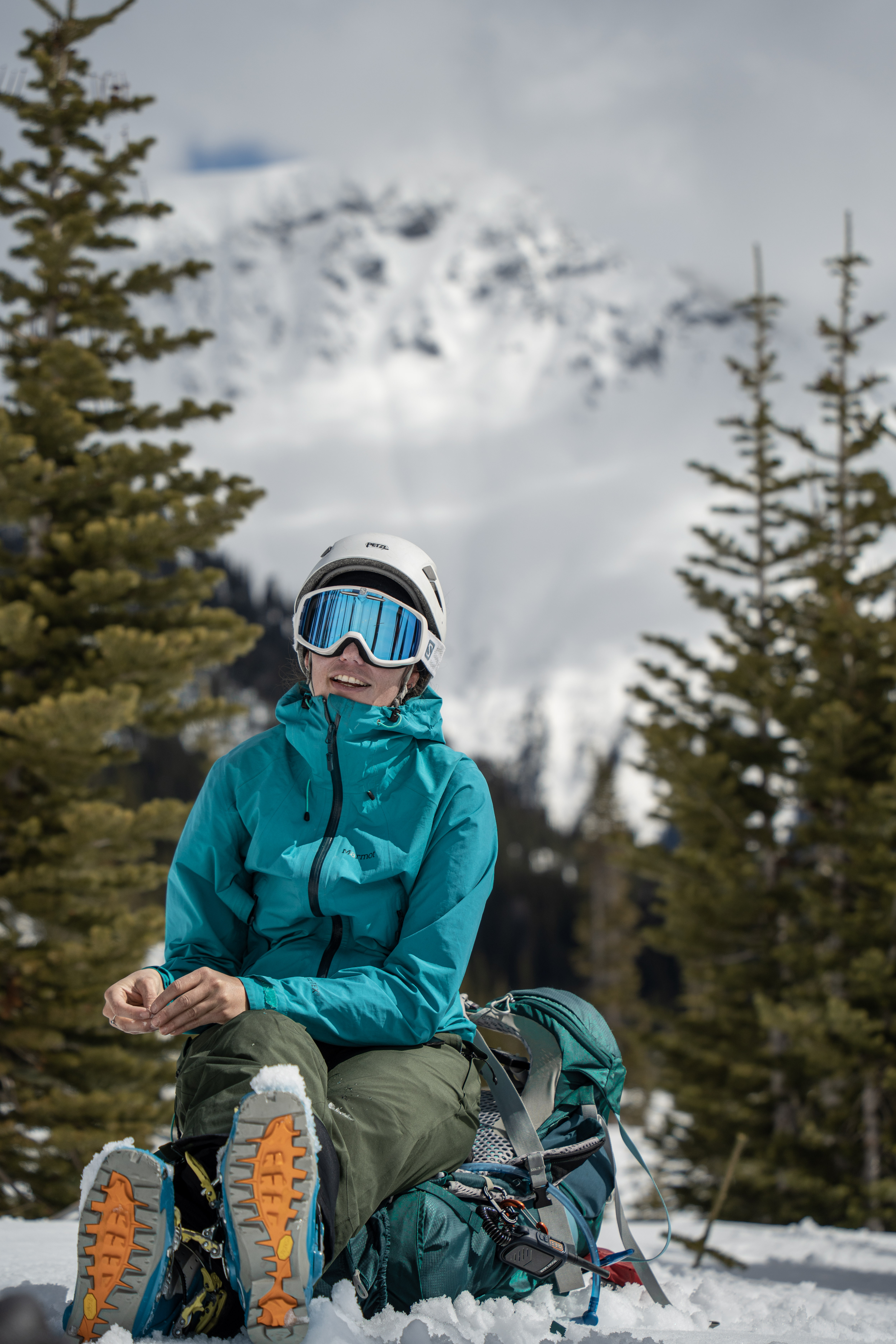
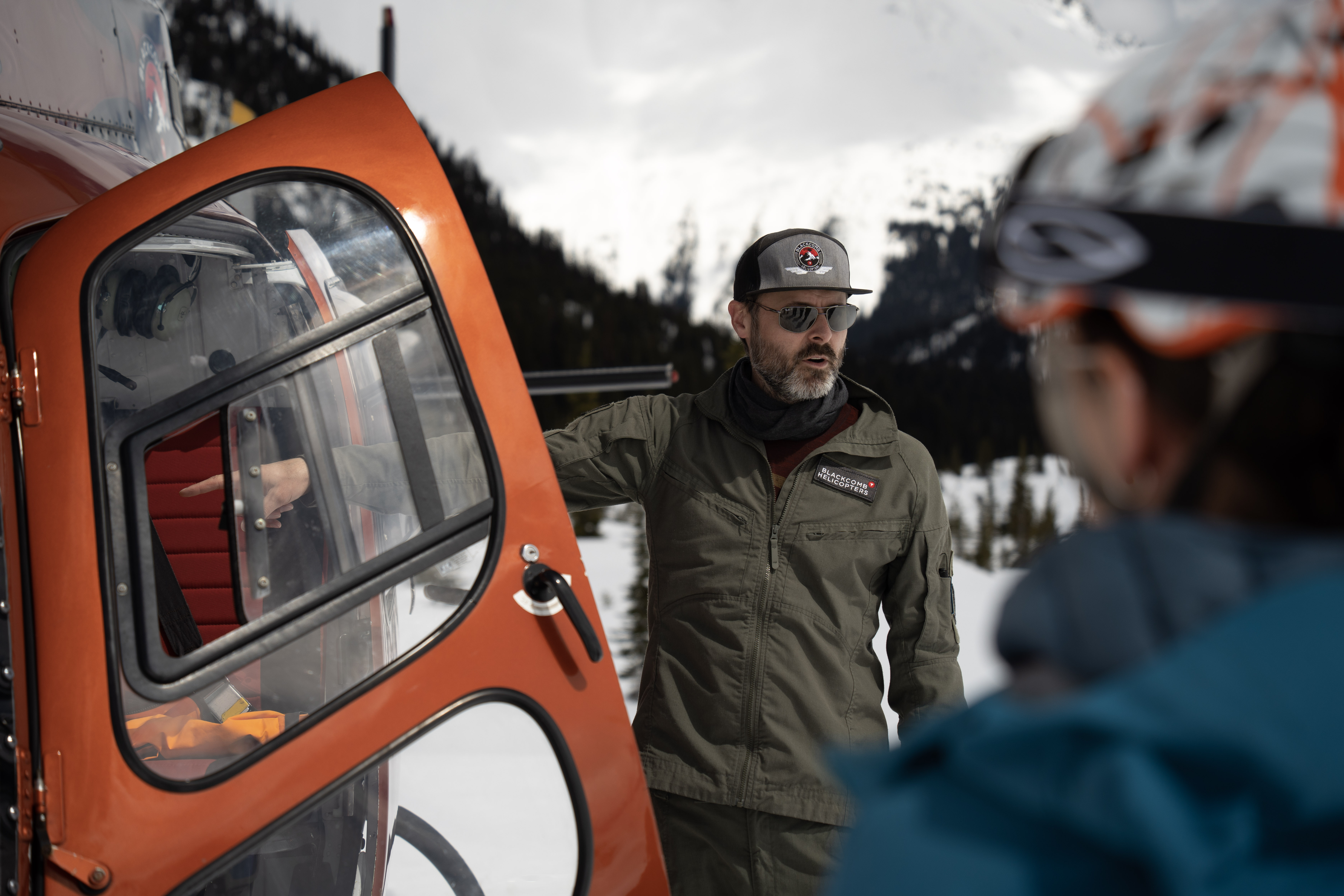
While waiting for SAR, we relaxed in the sun at our safe spot. We made hot chocolate coffee and shared snacks. Hana learns how to do an alpine coil. We see a helicopter circle in and out a few times, not certain if it was the same one as our rescuers. The SAR helicopter lands 1hr 45mins in. There was a team of three: the pilot, the SAR, and the SAR medic. The SAR jots down our case details, and promptly educates us on how we should not be out at this time. It is not usual May spring conditions, it is more like March…Given your experience level, Spearhead is a complex objective. We keep our chins down and nod in many yes’s.The SAR warns us splitboarders of the increased risk associated with having non-releasing bindings, which I shutter at since Hana’s board and sucked her legs deep into the snow.
Will and I ask the SAR medic lots of questions about her involvement and how she got here. We were baffled at how if the SAR medic uses medication or medical supplies during a rescue, she’s responsible in paying to restock her kit. There was no reimbursement for that. The helicopter ride paid to Whistler Helicopters is funded by the government. The two SAR members were unpaid yet treated us with the utmost professionalism.
We unload lots of thank yous to our rescuers while they go over helicopter safety protocol, pack in and bring down our bags, and drops us off at Whistler Helicopters. Two RCMP officers wait for us and instead of interrogating our case, they graciously offer us the 10 minute ride back to our cars. We’re just glad you’re out and that no one’s hurt the officer says. They told us if we made the SOS at night of the avalanche, it wouldn’t be until morning until the helicopter would come in anyways.
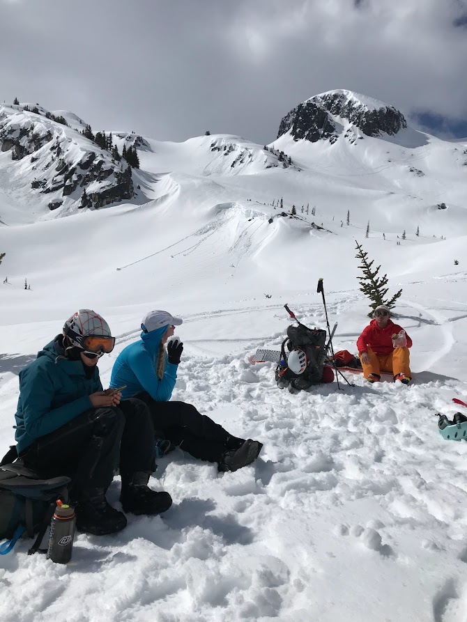
Waiting for the heli. MJ eats a fresh and undressed snow cone, and Will eats banana bread.
Cha snacks on sour keys and sesame crisps.
The pilot delivering heli safety protocol.
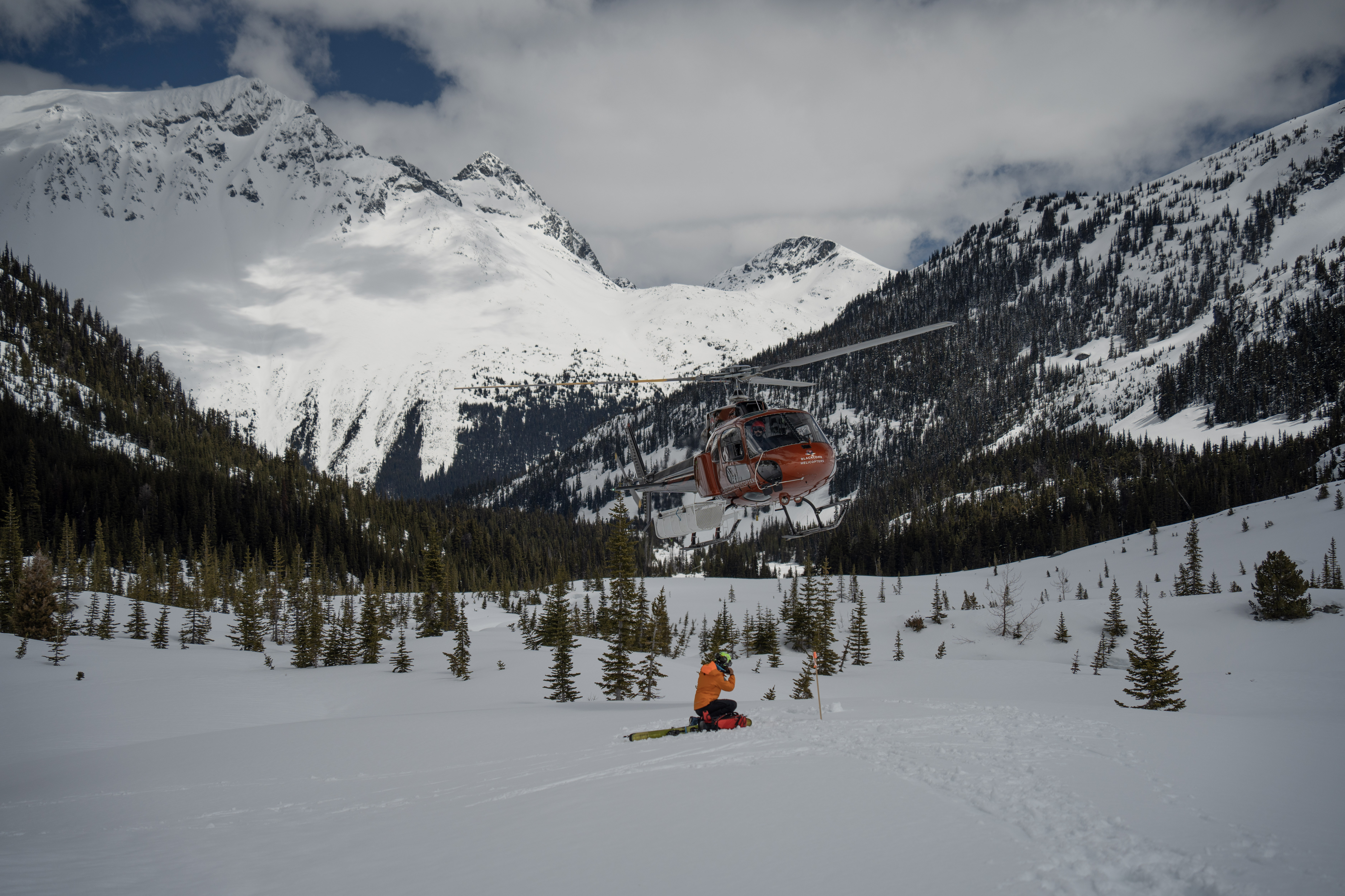
The first group of 3 up in the heli.

Riding a heli with my tail tucked between.
What Would We Do Differently (Hindsight)
May 18 Pre-trip
The first mistake was that avalanche risk was not discussed in context of cancelling or delaying the trip. There was a brief mention of the new 20cm of snowfall, but was quickly glossed over. If Avalanche Canada was still broadcasting, in the Sea to Sky, the forecast would have been considerable in the alpine. This means that natural avalanches are possible, and human triggered avalanches are likely. We assumed spring conditions and did not approach our pre-trip meeting with the mindset that we were likely to trigger an avalanche. We did not discuss route/timing plans that would have minimized exposure to avalanche terrain based on steepness, slope, and aspect. We only considered to ski some potential steeper objectives in the early mornings.
We all agreed that the planning was rushed. We were so excited for the clear visibility window. Historically mid-May would bring stable spring conditions, with its cycles of melt-freeze and lack of wintery storms. This year was an anomaly since as of May 19, it was still winter interms of precipitation and cold temperatures. The snow was abundant and the usual spring shedding had not happened yet. You don’t want to be in the mountains during the spring shedding, you wanted to experience the stability that resulted after. By rushing and missing risk assessment of avalanches, we overlooked that. This should have been the first red flag.
We didn’t discuss our experience levels prior. We realized that it had been the first or second season touring for 4 of us (although each with +12 trips), and Cha had ~7 years touring. A leader was not explicitly assigned as we all studied the map to a good enough level and thought plans would flow along the way. A leader could help collect thoughts, and suggest when and where to group up. Little things made a difference for instance waiting for those in the back so that they can take a chance to drink water and join on the group discussion.
May 19 Resort to Decker Lake
Cha and MJ talked to the ski patrol at the bottom of Showcase T-bar about why it was closed it off. The patrol said that there was 20cm new snow overnight, and they didn’t recommend being off the ski resort. This should have been another red flag. The rest of us in group didn’t hear since we waited outside the conversation. We were excited and just wanted to get started.
This was a common theme throughout the day. 2-3 people within the group would converse a little about risk, but we never made a greater discussion that would lead to a group decision. No pressure or dominating person had prevented us from calling off the whole day and coming back home. We simply didn’t collect our thoughts under a leader. The red flags only accumulated in our guts and brewed up bad feelings.
May 19 Decker Lake to Trorey Glacier
We realized that the traverse along Decker shoulder was a flawed path since it was overly steep and exposed. With it being an official FATMAP track, it must be a good path right? However, the correct path was to drop lower and completely circumvent the shoulder traverse, which was confirmed by the SAR. At the same time, when we were navigating we could not tell how steep it was due to flat light and whether the additional elevation loss would lead to more terrain traps.
We were incredibly lucky that an avalanche did not happen during the traverse around the shoulder. We all felt the wet, loose quality of the snow. The runout of the slide would have been loaded with terrain traps of rocks, snow lips, and steep gradient.
May 19 Trorey Glacier to Mt. Pattison
AST basics shout at us to avoid having more than one person traveling in avalanche exposed terrain. We gave thought about spacing out only when zooming downhill. If something were to happen, who would be the rescuers? When Will and I rejoined the group at the base of Pattison, we only overheard the plan in terms of efficient skinning and didn’t think of avoiding the wind slab or other considerations of avalanche exposure. Our minds blanked and we put one foot in front of the other, wanting to make camp before dark.
May 20 Rescue
The IERCC told my dad that next time in the backcountry, I should leave the following with him:
- Route of where we will be going
- Time that they should expect a message from me
- Who I was with and their address
In case the avalanche resulted in a full burial or if no one was able to press SOS, how could they possibly find us? In the future I’ll also use the free preset messages included in the Freedom Plan to check in at the end of the day.
Post Notes
After getting dropped off at our cars by the RCMP, Cha suggested we all sit down, share, and take notes. Thoughts, feelings, assumptions, let’s share it all. We should write a report so that others can learn from and prevent such an accident. We’re likely not the first group of VOCers to newly team up, and be so excited about an adventure that risks were at times underestimated. We grabbed a large vegan pizza to share at Functional Pie and here the report was born.
We group hugged and parted ways, grateful that for whatever we went through in the last two days, at least it was with each other. For most of us the touring season was done, but we were all excited to climb together. Some wrong choices teach us the right lessons in life.
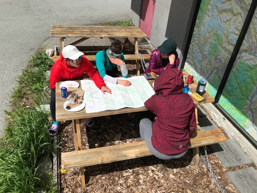
Post trip talk with the Spearhead map on table and remnants of pizza.
Very glad you’re all okay! And grateful for your trip report and willingness to share your learnings. Take care and be gentle with yourselves <3
Thank you for this trip report, it’s incredibly valuable. I’m glad you’re all ok, sending hugs <3
Thanks for sharing the story. I am glad to hear that everyone was alright.
Cool, you got to ride a helicopter. If somebody dies, it is a tragedy, but if you are all OK, it is a learning experience.
Thanks for the thoughtful and helpful trip report. Glad you’re all ok!
I was very interested to read that two of you heard a thunderclap-type sound when the avalanche started. I remember hearing such a sound in a previous avalanche, but I don’t know that my trip partners did and since then I had convinced myself I imagined it—-but maybe not! The sound comes back to me sometimes when I’m concerned about avalanche terrain, which is a good sort of warning I guess