The Thirteen Pass Route follows the iconic Skyline Trail from its start near Jasper to near its end, but before the Skyline’s final descent to Maligne Lake, the Thirteen Pass Route breaks off and connects to the Eight Pass Route, which goes from Maligne Lake to about half-ways to Banff on the Icefield Parkway. The entire trip is 85 km, and the middle 75 km is all above treeline. My son Devlin and I made an attempt at it a few years ago, but Devlin got sick on the first day and we bailed. This was going to be the year. I’d got all sorts of dried fruits together so that we wouldn’t be getting sick of standard camping fair. I’d had vacation lined up with Devlin’s spring break lined up for months.
During the week before our departure, I’d been working long hours so that my departure wouldn’t derail any projects, and hadn’t been following the avi forecast or thinking about the weather. The day before we were leaving, I got around to checking the avi forecast, and it was a disaster. Very high freezing levels, danger high in the alpine, treeline and below treeline, with persistent slab and deep persistent slab. We weren’t about to cross thirteen above-threshold passes in those conditions.
We paused our departure. I got some more done at work while we waited for conditions to improve, which took three days. We packed up, ready to start driving the next morning, and I did a last-minute conditions check. Just in case, I clicked on the caribou closures.
For many years, the backcountry around Marmot Basin has prohibited touring until spring conditions in May, because the wolves, which normally can’t navigate the alpine snow in the winter, are able to follow the skin tracks up and get the caribou, which are locally threatened.
During our attempt at the Thirteen Pass Route a few years ago, the route didn’t have a caribou closure, so I hadn’t really thought about it until just before we left, and I really didn’t expect to have a problem when I checked. My heart sank as I saw that the closure had been expanded and that ninety percent of the route was closed.
I fully support the Parks people doing whatever they need to do to protect the caribou, and I had only myself to blame for assuming that nothing had changed over the past couple of years.
Since we were all dressed up with nowhere to go, I spent half an hour looking at Google maps and found a big white patch just east of the tip of the Alaska panhandle. I drew a line from a glacier that the topo alleged went right to the highway—although the satellite imagery said this wasn’t true anymore—over a bunch of glaciers and a potentially problematic ridge, down into the coastal town of Stewart.
Our hastily thrown together plan

The Baldwin guidebook has long traverses near Terrace and Stewart. I’d vaguely looked at doing the Cambria Icefield a few years back, but it was big: fourteen days, the pictures all showed skiers pulling sleds, and the “it has been done without a food cache” indicated that this wasn’t the norm. Because all the stuff up there was way longer than we’d prepared for, and had references to Canadian Alpine Journal articles, I didn’t even open the guidebook. One might imagine looking up some of the nearby mountains on Bivouac or something, but that didn’t happen either.
I wonder if my route selection would have been different if I was aware that the route I’d chose was across the Cambria Icefield. Maybe I would have packed more than three and a half days of food. Fortunately Google Maps doesn’t display the names of most glaciers or icefields, so I wasn’t discouraged.
Most of the drive didn’t have much snow, including the long drive north up Highway 97 and west along Highway 16. Even Highway 37—which I’d imagine based on the treeline height would be extremely snowy most years—didn’t have a lot. Once we turned off at the Meziadin Junction to 37A, the snow started to pile up. It clearly wasn’t on par with a normal year: the avalanche-resistant, beefcake power poles didn’t have avalanche debris anywhere near them, and the massive 35-ton CAT 980 loaders parked along the highway hadn’t had to clear avalanche debris off the road all winter. Still, there was enough snow to start skiing as soon as we left the highway.
One of the beefcake power poles. The same power line had standard wooden poles when it was outside of a runout zone. Photo: Devlin

CAT 980 loader. The links on the tire chains are the size of a hand. Even chains half that size require a small crane for installation.

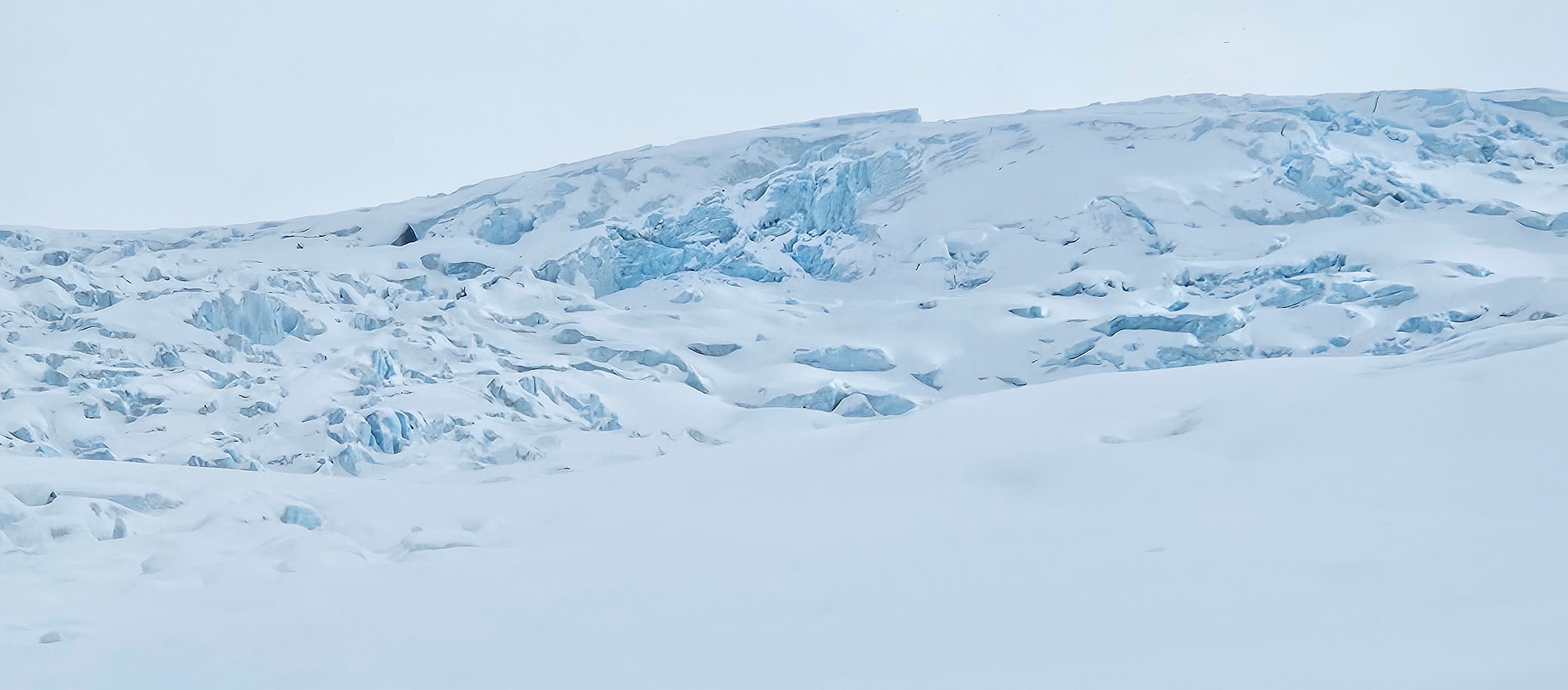
The topos show Bear River Glacier extending down to the highway, and being a smooth ramp. If the ice is deep enough, the profile is always gentle, but the thinner it gets, the more rough terrain under the ice shows up as icefalls, crevasse fields, and seracs. When we arrived, it wasn’t immediately obvious that it was going to go at all. The crevasse fields on the glacier looked significant, we couldn’t see a line to the top, and the region below the glacier was fairly lumpy, with lots of open rock.
The toe of the Bear River Glacier

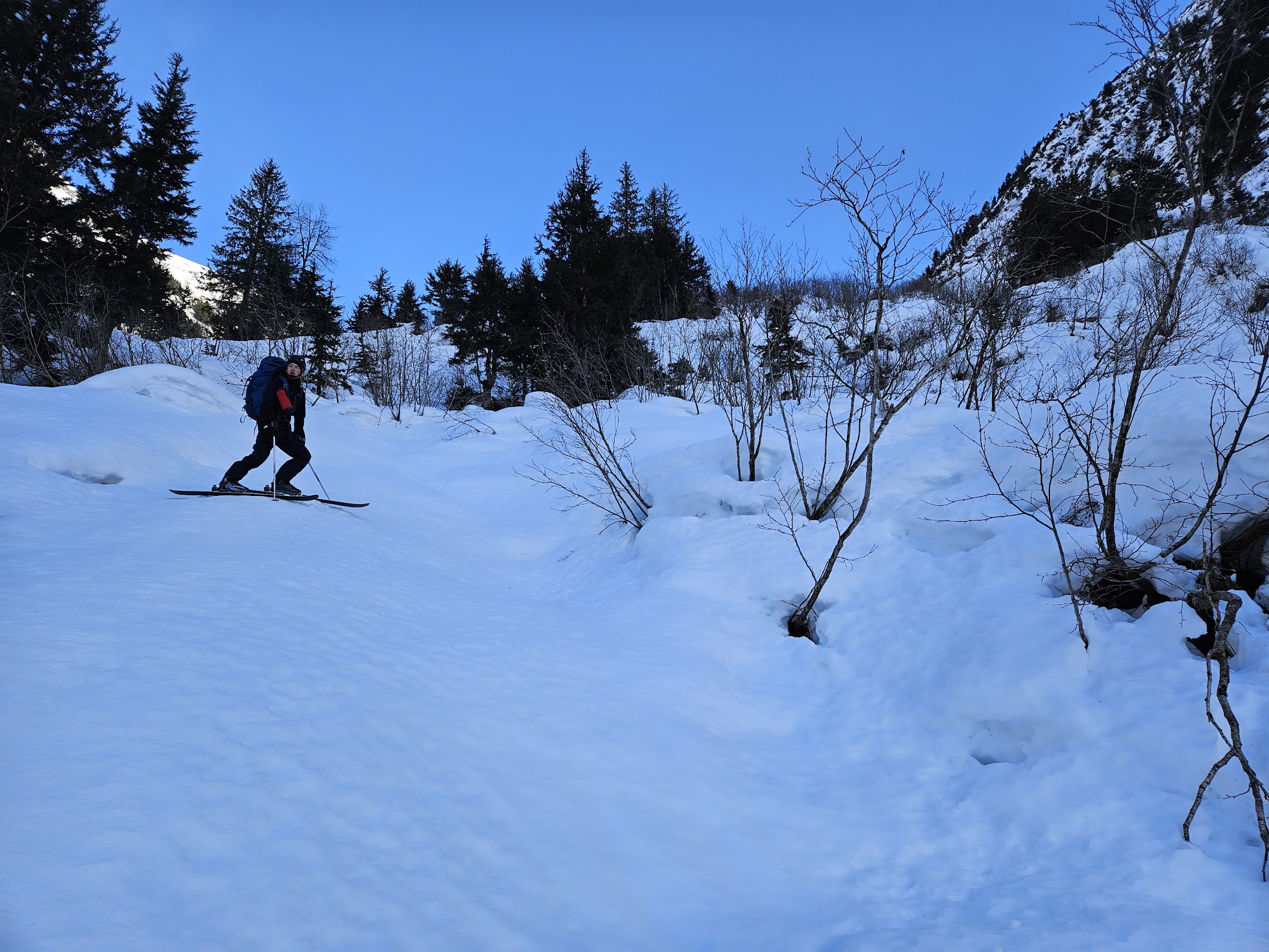
I had a bit of a slip crossing the creek, giving me two boot-fulls within fifty metres of the car. I poured the water out of the boots, wrung out my socks and we got started for real.
Looking back over my failure at creek crossing

The snow below the foot of the glacier was pretty crusty, with steep side-hilling to get around the blobs of rock. After a bit of slipping and sliding, we put on ski crampons and started to make progress. Still on snow-covered rocks, we worked to the right to avoid an icefall and got on the edge of the glacier. There was a moulin, a hole in the glacier where a stream disappears, within ten metres of the edge, so I took a look down to see if the ice was even a meter thick.
Bottomless moulin

It just faded into blackness and I couldn’t see the bottom. It was then clear that the rocks we’d been on were rockslide debris that was on top of the glacier, and we’d actually been on the glacier for a ways. At the elevation we were at—about 450 m—there was enough snow to cover a crevasse but not nearly enough to make a reliable snow bridge. We roped up.
The first icefall. All the icefalls had classic Gatorade Glacier Frost blue ice

Going up the Bear River Glacier alternated between mellow slogging and bands of broken ice. Some of these patches looked like they might present a real challenge, and they took some time, but we didn’t have to do anything sketchy to get through them.
Taking a break after making it through one of the icefalls

The last icefall
I liked this formation

In a normal snow year, the sides of the valley could easily avalanche right across the glacier, but this year it was mostly bare rock. The combination of low snowfall and it either being cold enough that everything just sloughs off, or hot enough that the sun melts the sides of the valley, removed any avalanche hazard for the middle of the glacier. We would sometimes hear the crack of an avalanche starting and see small patches of snow rip off to bare rock, but none of these made it even close to the middle of the glacier, and there weren’t any big patches overhead at all.
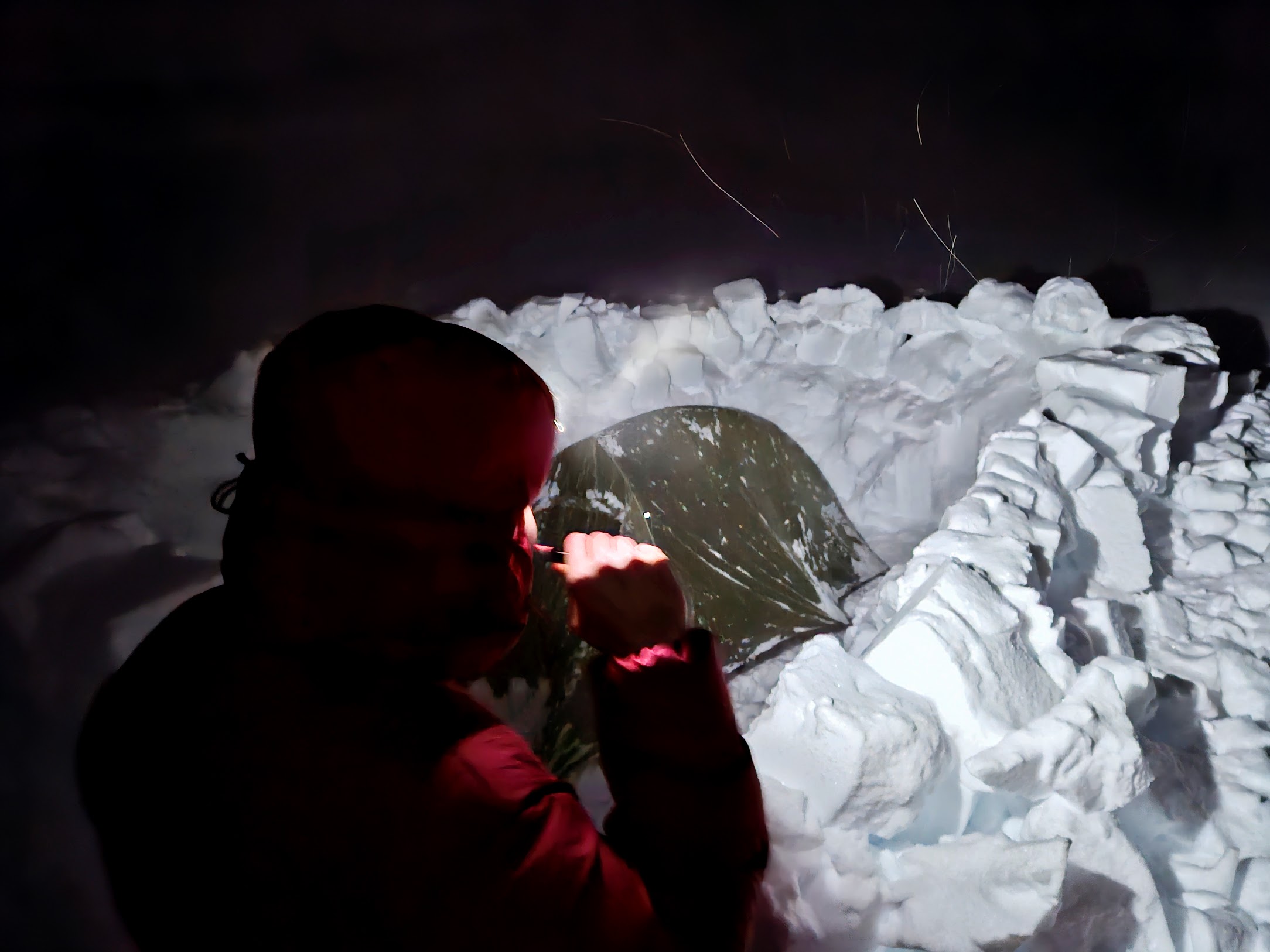
The last icefall region was the steepest and most fractured. There was an option to avoid it by a big snow-covered moraine ridge, but the avalanche hazard made us choose the icefall, which I think was the right choice. We got onto the flat icefield just as it was getting dark and the snow was starting. After some probing around, we took the harness off, made a wind wall and set up camp.
Devlin after getting through the final icefall

Brushing teeth before heading to bed
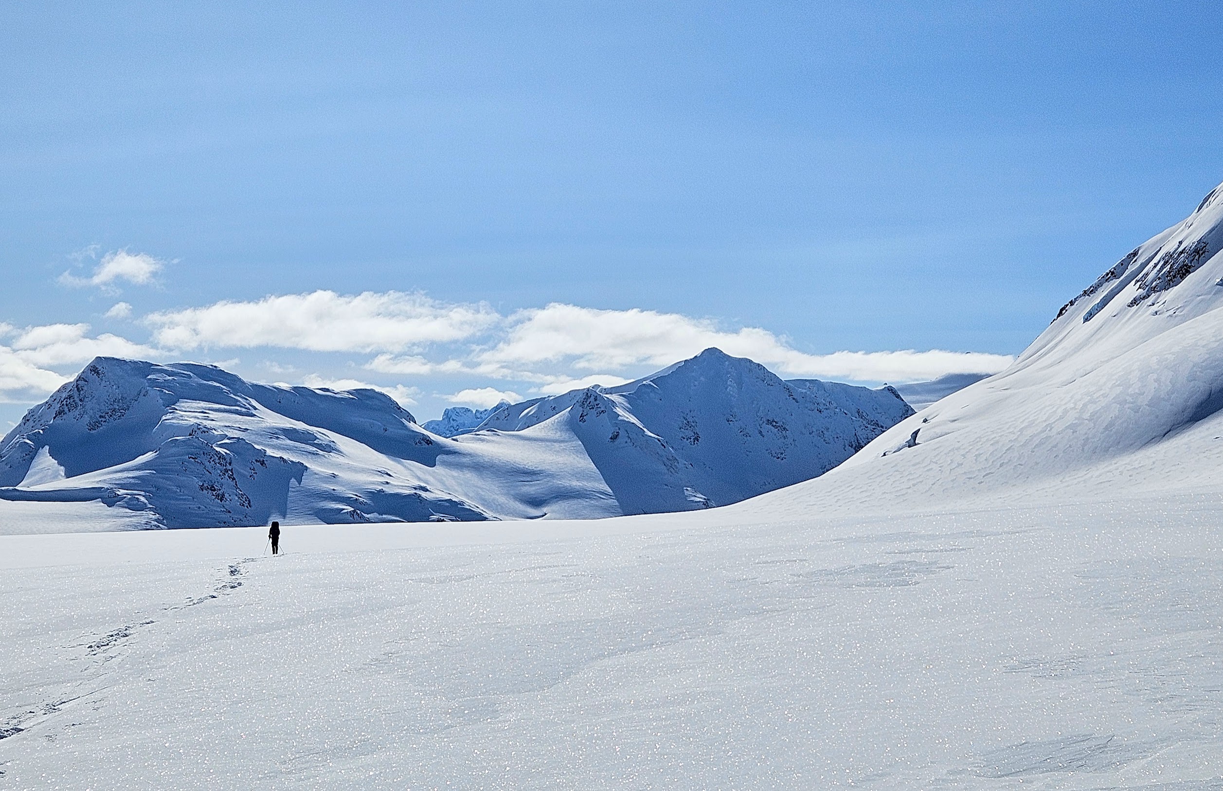
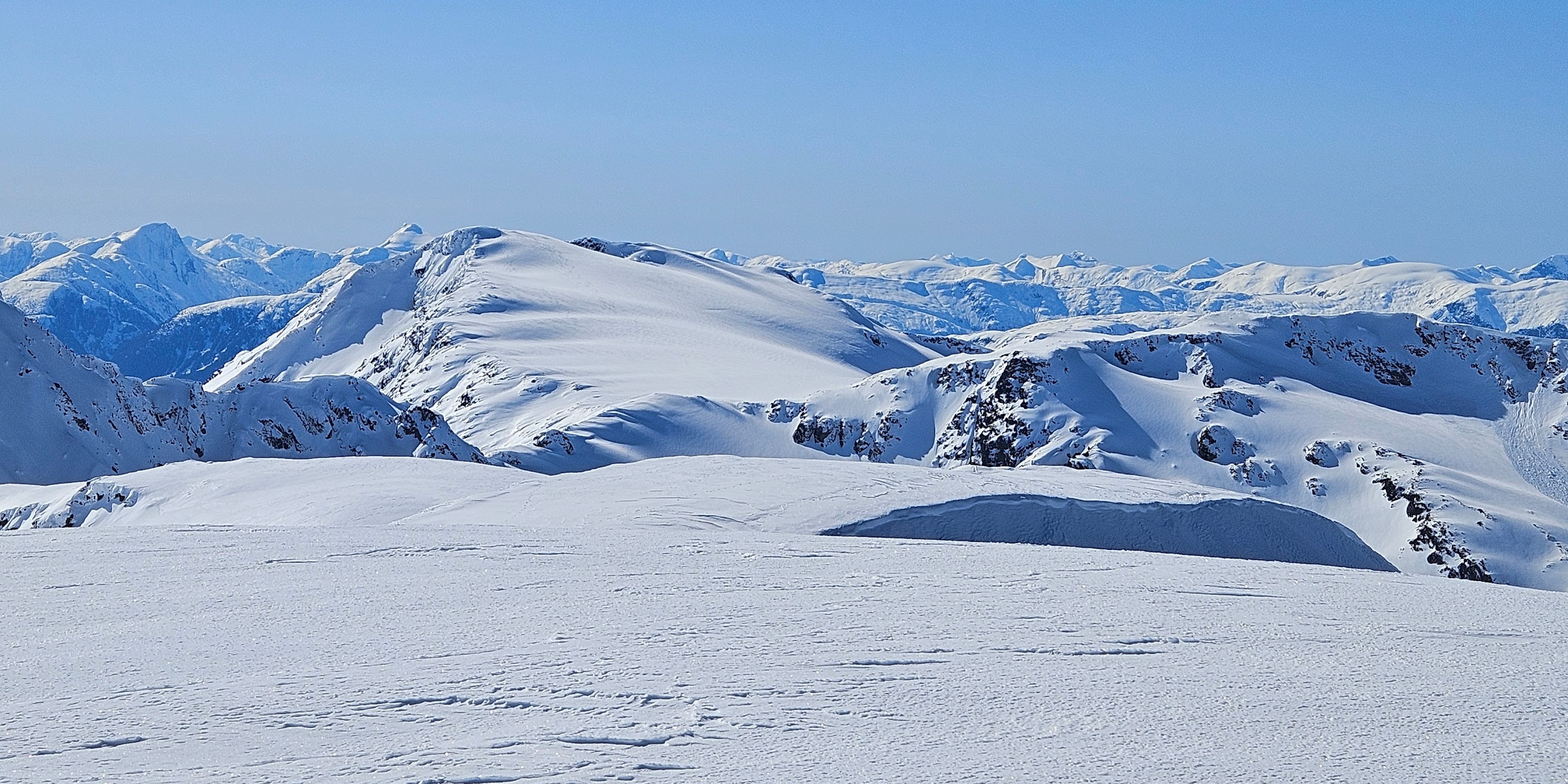
By the next morning, the clouds were breaking, giving us our first views of the icefield proper. It was spectacular, with mountains poking up from a sea of ice. At higher elevations there was a breakable wind slab, and at lower elevations a breakable crust, so skinning along was more work than the very low gradients would have implied, but still a long way from being terrible. We did about 35 km that day, and got onto the Cambria Glacier, the largest of the glaciers coming from the Cambria Icefield.
The view from the camp after we’d had breakfast and packed up

Looking back from camp. The car is parked at the foot of the back row of mountains

Bivouac has these labelled as Otter N2 and AG49, so I don’t know if they’re named.

Devlin heading towards the drop down to the main of the icefield. JG71 is the only mountain in view that has any kind of a name on Bivouac.
Otter, the highest in the area
Although we weren’t aware of it, we’d been following the route described in the Baldwin guide up until we passed Bromley Peak. From that point, Baldwin wants you descend east to the toe of the Cambria Glacier and then through rolling, wooded hills with the some smaller glaciers for 65 km until you come out near Kitsault. We went the opposite way, west up towards the top of the Cambria Glacier, and set up camp southwest of Bromley.
Bromley in front of us. We’re still on the Baldwin route at this point. The Baldwin route goes down and left after Bromley, and we went up and right behind Bromley

Otter is hiding behind Devlin’s pack, although the flank is visible to the right. We came between Otter and the pointy one immediately to the left of where the glacier meets the sky.

Booting up for day 3

I’d been thinking that we’d do Bromley Peak on the third day, but thought better of it when we’d skied around and got a look at it. The last 50 m or so was covered in something that kind of looked like seracs, although I had my doubts because it wasn’t supposed to be glaciated there. Rimed gargoyles? I don’t know, but it was kind of dodgy. The sunlight reflecting off the snow indicated that there was substantial sun crust. Would it be possible to self arrest? When we were digging the wind walls for the camp sites, we’d been finding weak layers too. We decided not to give it a shot. Bromley will still be there, and it’s a cool enough area that I’ll probably be back sometime.
The flank of Bromley to the right, with a portion of the icefield we skied yesterday visible past it. Although it isn’t visible in the photo, Bromley Glacier is at the bottom of the valley between us and yesterday’s icefield.

The side of Bromley I’d hoped to go up. The shiny crust, lumps on the summit and avalanche potential scared us off.

We spent the morning cruising by some spectacular scenery: to our right, Bromley Glacier; and to the left, rugged British Columbian peaks with Alaskan ranges behind.
A thin band of ocean, the Portland Canal, separates the Cambria Icefield from the Alaskan mountains in the background

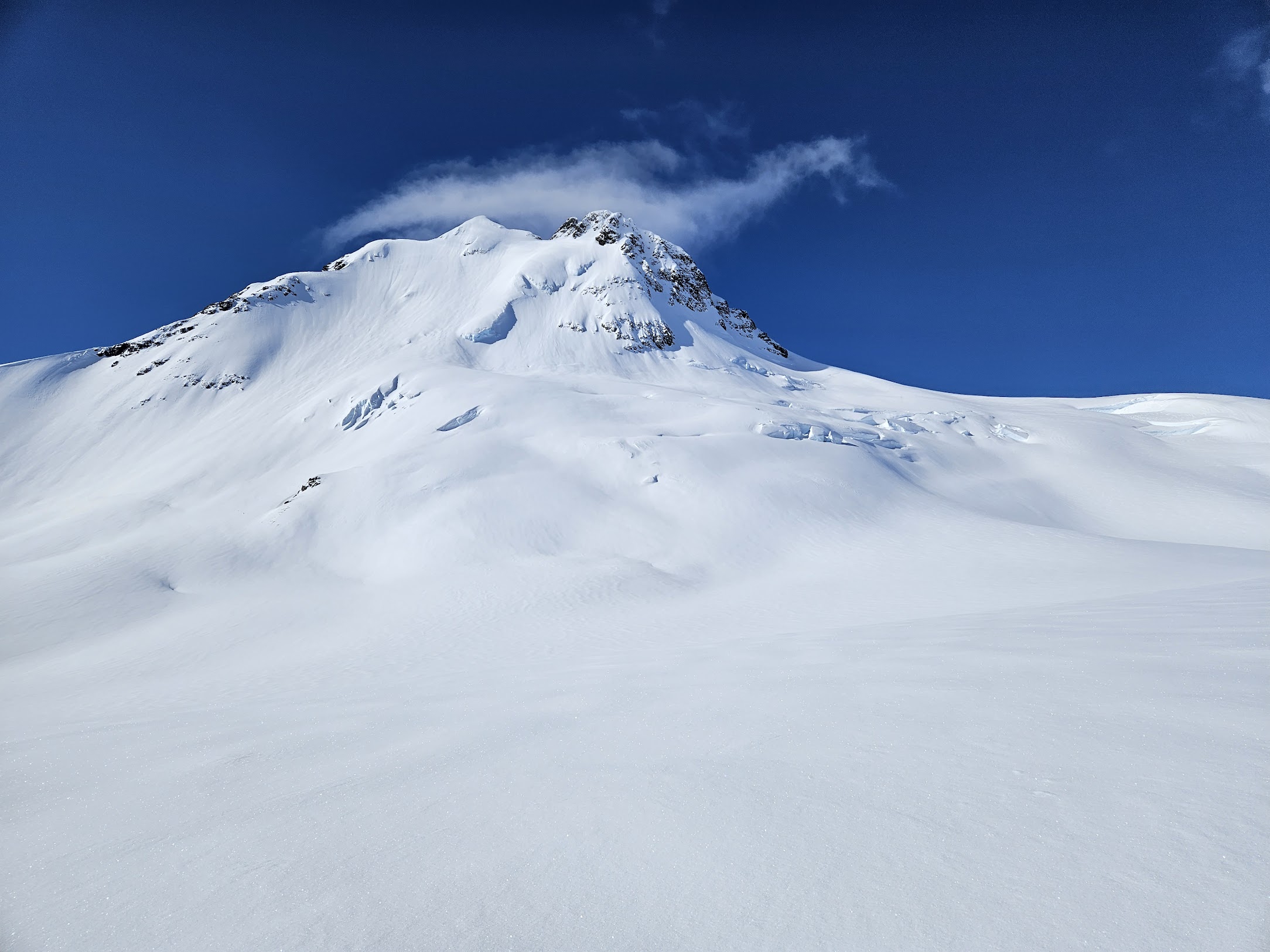
At a break, I checked where we were and noticed that we were moving faster that I’d thought, and that one of the rugged peaks I’d been admiring was Mt. Magee, which was our planned exit from the icefield. We were supposed to go up the back of a bowl and over a col, but it looked too dicey. The sun was out, and with the bowl being sheltered from the wind, it’d be easy to imagine that it was softening up, even though the snow we were on was still dry. After some humming and hawing, we went up the big domed subsummit to the right. It’d expected it to be any icy debacle, but it went pretty easily.
Mt. Magee. The summit is the pointy one on the left, the ridge we’d planned on is at the back of the bowl, and the subsummit we went over is the lump to the right.

We’d been seeing wolf tracks, which seemed odd, since there really isn’t anything for wolves to eat up on the icefield. I’d gone 30 km without seeing a single piece of vegetation at all, and a couple days without seeing anything that wasn’t more than 5 km away. As we came around the last cornice and got a view up the final dome, we saw two wolves looking at us. They paused for a while and started trotting up the mountain away from us. Had the wolves been drawn up from the valley by our food? Or just by us? I couldn’t fathom anything else that’d have brought them up.
Wolf tracks

Wolf attacks on people are extremely rare. They did eat a solo camper in Saskatchewan a few years back, but when the news of that came out, they were pointing that the previous wolf attack in North America was a century ago. Because of the rarity of wolf attacks, I’d never been disturbed when meeting wolves before, but in all other contexts there was an obvious food source other than us.
We followed wolf tracks up to the summit. After taking in the scenery, we noticed that the wolf tracks continued towards Barney Gulch, our descent path. I had mixed feeling about this. It showed that it was possible to get down without getting cliffed or corniced out, but it also meant that we were following the wolves.
Scenery from near the summit

Devlin looking at his phone instead of the scenery

View from the subsummit we did showing the true summit of Magee (centre-left) and the ridge we were intending to break over

Looking the other way from the subsummit
The first 1000 m of the descent looked spectacular, but was fairly bad skiing, with hard crust and some places where you couldn’t avoid skiing the refrozen avalanche debris. It wasn’t the worst avalanche debris we’ve skied, but it was worse than most. I give it a 2.
We needed to follow the ridge to the big dome in the centre-left, and the drop into the second gulley

Devlin contemplating the descent ahead

Note that Devlin isn’t leaving a hint of a track

Devlin heading towards the glacier in Barney Gulch

Avalanche debris

We had our supper at the toe of the small glacier at the head of Barney Gulch, where running water came out from under the avalanche debris. Skiing the junk we were on, with a heavy pack including camping and glacier gear, was really giving my legs and feet a beating, and it was getting late. We talked about whether we should camp or try to make it to Stewart. We didn’t have a vehicle in Stewart, or a place to stay. It’s a town of ~600 people. If we showed up in the middle of the night, we’d have no chance at getting a place to stay and would be for sure camping in a gas station parking lot. I only had snow stakes, which are maximally incompatible with parking lot. On the other hand, it’d be nice to wake up in Stewart and have some time to explore, and there were the wolves. Devlin wanted to head down. We were still out of cell range, so Devlin sent an inReach message to Iva—my wife and his mom—and asked if she could get us a room in town, and when checkin closed. We assumed it would work out and headed down.
Supper time

I’ve skied worse, but only a few times. The snow had mostly weighed down the alders, such that most weren’t sticking out, but every alder was a big, snow-covered lump from the uphill side, but often had an open hole on the downhill. There was a crust about an inch thick, which most of the time didn’t yield but every now and then broke through to alder and mush. Typically this would happen happen when sliding down a groove where only the tips and tails of the skis were making contact.
This is before it steepened up. I regret not getting a picture when it was really bad
The topo is old and not super-accurate. It doesn’t show the subsummit we were on (about 2 km NNE of Magee) properly, but it gives a good impression of what skiing down beside the creek in Barney Gulch is like. We were right by the creek, skier’s left, until it mellowed out.

During this descent into madness, we got the inReach message back that Iva had booked us a room and that check-in closed at 10:00. That left us two and a half hours to drop 700 m and hike into town.
As we got lower, the portion of the alder that was sticking out got larger, the holes got more frequent and the break-throughs more frequent. My legs weren’t able to keep on skiing like that, and it looked like the mature forest to our right would be walkable, but where we were, I couldn’t stand without sinking to the centre of the earth. We took the skis off and crawled through the alder. Devlin commented that it was really saying something about the conditions that what we were doing was easier than skiing.
Once we got it into the coniferous forest, it was still pretty post-holey, but it was manageable. It had never been logged, and there wasn’t too much devil’s club, and although we did get cliffed out a few times, we were able to traverse around the problem areas reasonably easily.
Getting past the snow

The usual

On the way down, Devlin kept referring to “the beach.” The topo showed about 500 m of totally flat ground with no trees between the edge of the forest and the highway. I warned him a few times that I interpreted that as terrible. Alder flats? Brambles? A marsh? I wasn’t sure what it was going to be, but I was sure it wasn’t going to treat us well. Devlin kept calling it a beach, though.
We got around the last cliff and down to the “beach” just before 9:00. I was unfortunately vindicated. We didn’t make it ten metres in before we’d each filled both of our boots up with marsh goo. That was somewhat liberating as we were able to slosh through whatever and not worry about getting any wetter or grosser than we already were.
We could see lights up ahead, crossed a beaver dam and waded through a creek before breaking through into an industrial yard, which connected with the highway.
The “beach”

Boots aren’t getting any wetter

From there it was a straightforward, brisk walk 3.4 km along the highway to the hotel to make it there before checkout closed. We were pretty trashed and had boots full of muck, so this was a chore, but we made it with a full ten minutes to spare.
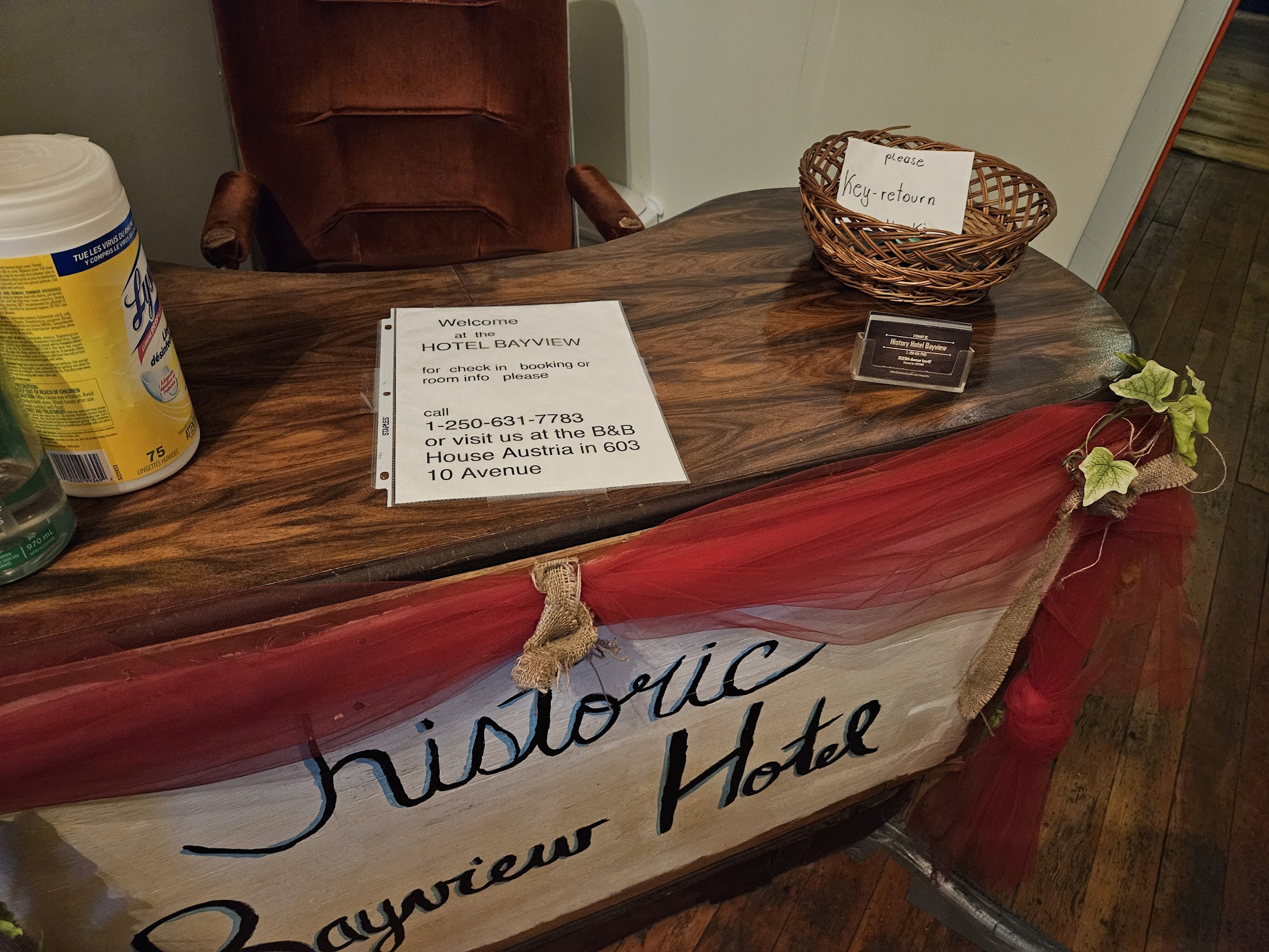
When we arrived, there was no one at the hotel, but it was unlocked. I called the number posted and a cheery guy said that he’d talked to my wife, to just head to room 21, and that the key was in the door. It was an old-school key too, not a readily replaceable access card. I guess they don’t have a lot of crime there.
The industrial yard

I took off one boot and my foot came out with a splash of mud onto the carpet. I felt shame and finished getting the gross stuff off in the shower. Washing the ski socks in the sink was an experience. It’d get totally opaque green-brown, I’d drain and refill, mash the socks around for a bit and get back to the same opaque sink, again and again and again. It seemed to be in violation of a number of physical laws. I spent a bunch of time in the shower working on the boot liners, stuffed them full of towels and went to bed.
The next morning, there was still no one at the front desk. I called again to ask about checkout. The dude then took my credit card, and asked me to toss the keys into the basket on the desk.
Trust
My feet

The previous night, we had made plans to walk to the ocean and the Alaska border in the morning, but we made it about a block before our feet and legs decided that Trudy’s Temptations looked like a fine bakery and we should just loiter there. The bread shaper machine was cool. She called a bunch of people trying to get us a ride, but no dice. I chatted up some other customers until we found someone that wanted to take us up to our car at the Bear River Glacier.
After getting to our car, we went a bit down the highway to eat lunch at the Meziadin Junction. There was a restaurant advertised, but we couldn’t find it. There was a gas station and a work camp, where loggers and miners dorm during field work. A bit of asking around revealed that they served the general public in the work camp cafeteria, but you’d have no idea from the outside. Despite there being a lot of Atco trailers, implying a large crew, no one was there except for the cook. He told us that since it was Friday all the workers had left. He noticed that we were both walking gingerly and asked what the deal was, so we told him. He thought it was cool enough that he gave us free desserts.
Does this look like a place where the general public can get a meal? Note the chain hoist holding the roof together.

Inside didn’t look like a place where you could get a meal either

The inside of the cafeteria

In Prince George, we bought a pair of tweezers to extract the devil’s club Devlin had accumulated.
Overall, I’d highly recommend the trip. The route we did had more travel on the actual icefield than the Baldwin route, and a lot less low-angle forest. Our route did have some high-angle forest, though, which Baldwin’s did not. In a normal winter with more snow, and without a big melt-freeze cycle, the descent to Stewart could really be the highlight of the trip. If there wasn’t the crust and the alders were properly buried, it’d be a drop of a bit over 2000 m, including a 600m drop in 1 km horizontal distance. It is of course complex avalanche terrain, so one would need to be prepared to wait or bail if conditions weren’t stable. Bailing could mean doing the full Baldwin route, going all the way back to the Bear River Glacier or going down to the ocean south of Magee, which would totally work but result in a 5 km coastal bushwhack to Stewart, on a steep sidehill. Regardless of which way the bail went, it’d make the trip a lot bigger.
A tip is that we found out that the Sluice Box Trail is just 100 m south of where we had our adventure with the “beach,” and it at least has a bridge over the main watercourse. Given how close we were to missing check-in for the hotel, we might not have bothered trying to find it even if we were thinking about it, but it’s clearly the better thing to do if you’ve got a bit more time.
Full panorama from the subsummit of Magee Photo: Devlin

You guys are epic.
The feet pic is is a nice touch; I think Veenstra did something similar on his Triple M triathalon report. I’m wondering if this might evolve into standard practice for the more serious VOC trip reports…
To the extent that I grew up, I grew up at Torbrit Silver Mine which was 17 miles up a bad road following the Kitsault River, from Alice Arm. We came and went via the passenger boat that came up once a week with food and mail, or if we were in a hurry we got the local lady to radio out for the float plane. Usually the boat dropped into Stewart as well, and would stay there long enough for us to walk across the border to the USA and get Hyderized in the pub there. More recently we had a VOC agent in Stewart, who might have been called Lia, and had something to do with dropping dynamite on avalanches from helicopters.
I am amazed that you can now drive to Stewart on the 37A.
Wikipedia claims that the road to Stewart, highway 37A, was built in the 60s to transport asbestos to Cassiar, but that 37 itself was only extended to reach Kitimat–and thereby the rest of the highway system–in 1986. Whether that’s a recent development or not is I guess a matter of perspective.
Wow this is a stunning report. What a place! My friends and I were nearby (ish) in Terrace this year and deeply considered driving up to Stewart and Hyder just for something to do. Didn’t end up going but theres definitely an extra note next to Stewart on the bucket list after reading this. Love the notes about the hotel and the “open to public” restaurant. Whole report perfectly captures the soul of the area I think