January 26th
Stats:
17km / 1,200 elevation gain
C2C 10 hours (moderate pace with very few breaks)
Participants: Harrison C (organizer/leader), Paul R (myself)
Gear (all needed): Snowshoes, Crampons, Ice axe, Avy kit, bike (cuts ~5km)
Blinch Peak is an obscure and rarely ascended peak roughly 30km north of Mission close to the northern end of Stave Lake. Culminating at 1,511m, it offers some pleasant alpine-like travel with the right approach, and the bald summit offers some of the finest views of Mt Robbie Reid and Mt Judge Howay, which was the main appeal for me. The goal was also to tag Flinch Peak, which is one of the other peaks forming the cirque around Blinch Lake, but we ended up bailing on that one.
Getting there:
We left downtown Vancouver around 6.30am and reached the end of the paved road north of Mission at 8am. To get to the “trailhead”, we drove on the Lost Creek FSR for 16km, which took almost 45min. The first few kilometers would probably be doable with a regular car but the potholes become very wide and deeper after that, so it’s definitely high-clearance/AWD territory (one semi-frozen puddle was covering the entire road for ten meters and was probably too deep to be crossed without clearance). The road continues past 16km but is intentionally blocked by dirt piles. That’s where the bikes came in handy! (there’s evidence that people have bypassed the obstacles but I don’t think it would be worth it considering the massive ditches found not so far down the road). We biked for a couple of easy kilometers until we reached a deep and wide ditch where the bridge was taken out (on the snow towards the end) – any bike with decent tires would do, my gravel bike was quite fine but a mountain bike would be more comfortable.

End of the rideable section
Bushwack to the ridge:
Harrison had made some homework which paid off: he drew a route through what’s left of the old growth forest in the drainage southwest of Flinch. After a bit of dense bushwhacking (both on what’s left of the FSR past the missing bridge and after we headed upslope), we reached the giant trees, where there wasn’t much on our way, so up we went! We did get surprised by a fairly deep canyon that wasn’t showing up on the maps, so we donned the crampons and downclimbed facing the slope. The snow being very supportive this went very smoothly. In no time (but not without effort!) we reached the col, put snowshoes on (as the snow was powdery and deep), and headed towards our first objective of the day, Flinch Peak.

Blinch is the white dome-shaped peak in the center
Flinch 1 – 0 VOCers
We had been able to see Flinch from down the valley and the summit block looked insanely steep . This didn’t change once we made it to what seemed to be the crux – time to put the crampons back on. The slope started at 45deg and quickly reached 60deg. Unfortunately, the snow (exposed to the sun) was not supportive at all and kicking steps was only shaving the snow off the slope. While I was failing miserably in my attempt to reach a tree to veggie-belay myself up, Harrison managed to reach the trees a different way. It was past noon already and Flinch was still not in reach, and Blinch looked so far behind us, so we agreed that we would give up Flinch in order to maximize our chances of success for Blinch.
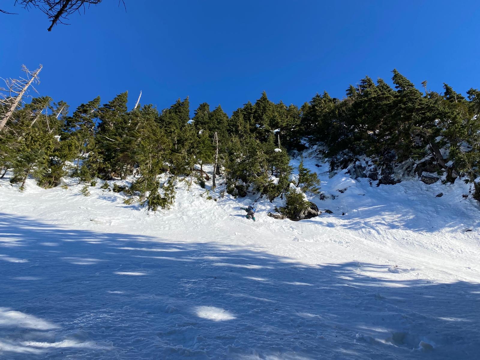
Steep Flinch – the slope close to the trees reached 60 degrees…
Traversing to Blinch Peak
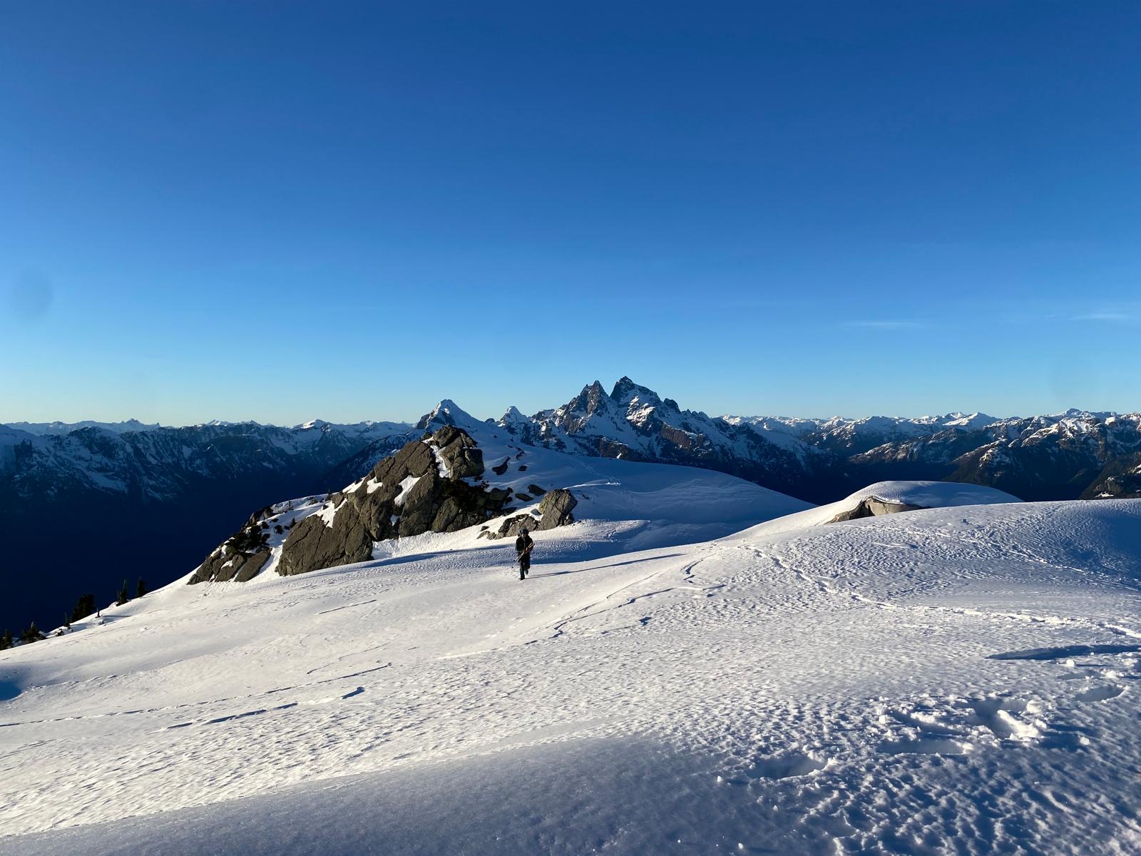
The ridge to the top of Blinch includes 3 bumps, the first one looking pretty prominent, so we figured we would traverse the shaded slope below all bumps and only gain the ridge to ascend the true summit. This is only doable with low risk of avalanche, there’s a lot of terrain traps below and even a small avalanche could have dire consequences. We did the entire traverse with the crampons on and it was fine (there was all kinds of snow, from powder to rock hard wind affected surfaces!)

Traversing towards Blinch Peak
Once on the summit block, the summit itself kept moving further away as we climbed bulges of snow, but at last we did reach it with barely more than an hour to spare before sunset and seven hours after leaving the car! The views from the top are gorgeous, the Judge and Robie Reid standing proud and tall to the west and Mt Baker (aka Kulshan) and Shuksan looming in the southern horizon.

Two local icons: Mt Robie Reid on the left and Mt Judge Howay on the left, seen from Blinch Peak
Time to leave the summit! The Judge is in the background
We started plotting the plan for the descent and decided to go over the first bump, follow a contour line on the second bump, and then cross a gully. The sunset glow was amazing as we were reaching treeline and we still enjoyed some light as we starting plunging into the bush.

The sun was descending faster than us!
The descent was overall not so bad but caution was required as there are some cliffs and creeks here and there. Close to the FSR travel became easy as that part of the forest was victim of a wildfire and nothing much has grown there since. Bikes were then recovered and the ride back to the car under the star-dotted sky went smoothly!
We made it back to the car at 7pm pretty tired! I’m very grateful for Harrison driving on the heavily potholed FSR at night! All in all, this was a great day with amazing views as soon as treeline is reached. A very cool adventure for anyone looking to go off the beaten path in a rarely visited area.
In retrospective, I would recommend starting the day a bit sooner if the intent is to bag both peaks (maybe 8am at the latest) although finishing in the dark is pretty inevitable. A firm and safe snowpack is definitely a must for this as it goes through avalanche terrain quite a lot, and powdery snow would make for extremely painful travel.