Artem and I (Piotr Forysinski) had decided to do something cool together over the Easter long weekend. Our initial plan was to attempt the Cheam Range traverse, but the more I found out about it the more moist my underwear got, and without a third person and a second car we had good reason to set our sights elsewhere. It was fairly late on thursday night when I came up with the idea of heading onto the Chociwa Glacier and the Kwoiek Peak area. “It’ll be a bit of a slog, Artem…”
“Oh yeah?”
“But no, it’ll be awesome and-uhm- can I pick you up at 630? I’ll show you the map and the route when we stop at Timmy’s in Chilliwack!”
“Sure, goodnight!”
But Artem fell asleep in the car along Highway 1 before we drove through Chilliwack. So I kept going to Hope. At the new Timmy’s in Hope I cunningly ‘forgot’ the map and guidebook in the car. I had brought the whitewater paddling guidebook with me because it had a better description of the logging roads and the Nahatlatch mainline than any other reference I had – and so I made Artem navigate us to the trailhead using that innocent little book. We hit some snow on the Nahatlatch road a few km before the Log Creek turnoff, but it ended up being absolutely perfect for us – the mainline had been driven on previously by larger trucks and therefore their tracks made it possible for me to drive it also. The Log Creek logging road hadn’t been driven on and was snow-covered right from the turnoff. There’s an old bridge that’s falling apart a few hundred metres up that road, so that’s as far as we were going to be able to drive anyway.I was fully expecting to have to carry my skis for a few km – the road at the turnoff is S facing at only 1000 ft above sea level.
Once securely parked at the trailhead, I pulled out the 1:50k map and unfolded its many folds onto the car to go over the route with Artem. He looked at me half-expecting me to start folding the map over so as to reduce wind flap factor. But no, I needed most of the width of map to show him my proposed route in its entirety.
Some minutes later:
“But why on earth would we want to do this to ourselves?!?”
“Ehm, well, what’s the name of that summit at the head of Log Creek again? ‘Longslog‘. Isn’t being able to summit that peak reason enough for almost any amount of suffering?”
Artem agreed and took to the idea vehemently. He almost got more enthusiastic than I was. That’s why I really like going on trips with Artem.
And so we set off, skinning from the car, half-expecting to have to walk a few kilometers somewhere higher up carrying our skis – which to our delight and surprise never happened. We only had to take our skis off once to cross a creek, although a few fallen trees and a landslide on the first kilometer or so of the road required some maneuvering.
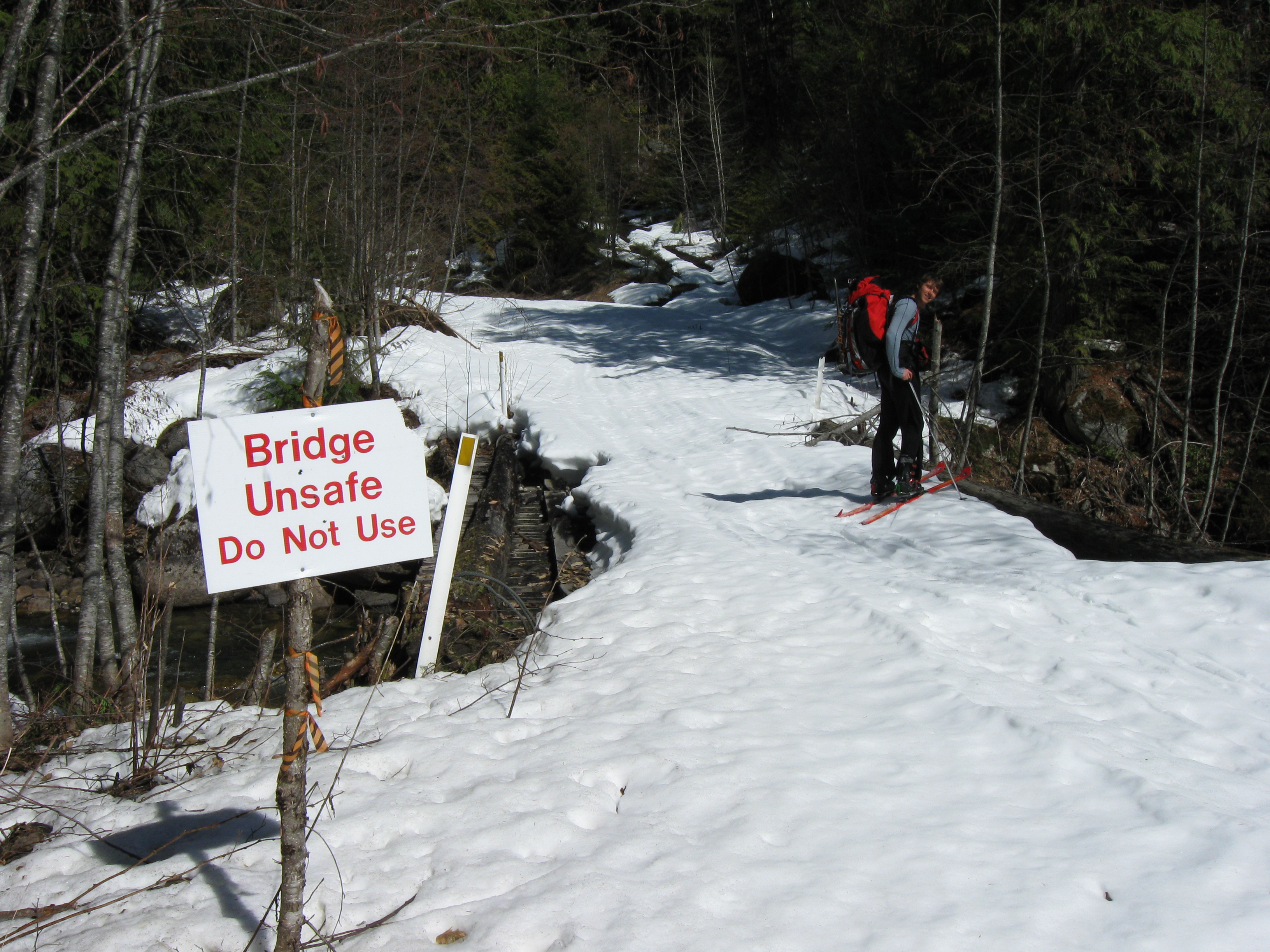
This bridge had looked sketchy 2 years ago, when we decided not to drive it. One of the major support logs has since fallen off, so it is even sketchier now.Thou shalt not drive over this bridge.Well, unless though art driving a snowmobile or an ATV.
After some 7 km or so of slogging up Log Creek, we started seeing a taster or what we were heading towards. As we rounded a turn in the creek where it changes from NW facing to W facing, an assortment of peaks on the ridge E of Tachewana summit revealed themselves, each one cooler-looking than the previous, and each one revealed with a further step up the road. We hit the end of the valley at about kilometer 12, and dropped down to the creek to keep going up the valley.

Nearing the head of Log Creek; gully leading up to the Chociwa glacier visible at centre. "Longslog" summit right of centre.
We covered another 3 km or so along the valley, but it was nearing 6pm and we opted to go up the steep and narrow gully early the next morning instead of that afternoon.We camped in the last significant clump of oldgrowth.
The next morning we got up early, switchbacked up the gully, dropped our overnight stuff at the Tachewana-Longslog col and sometime around 10am we were standing on the summit of Longslog, having gained some 900 m from camp – including a short bootpack to gain the ridge going up to the summit. Awesome – 22 hrs into the trip, 2000 m up, 18 km in. Longslog. We unanimously decided that the only suitable summit pose for ‘Longslog’ was ‘barely’, although we were both feeling very energetic and excited to venture out onto the glacier proper.
We skied off the summit directly down the west face (rather steep at the bottom), picked up our overnight stuff, and headed West. Some 5 km and 350 m up we were on a ridge separating the Chociwa glacier from the Kwoiek glacier further west. We pitched camp here, melted some snow for water, and headed for Kumkan peak.
The NNW ridge of Kumkan offers a really fun skin-up directly to the false summit. From here we looked at a rocky, rimed up ridge which seemed to lead slightly higher than the bump we were standing on our skis. Artem expressed a slight lack of faith in our ability to make it to the true summit, but I was already busy skinning across to the base of that ridge and unstrapping my ice axe. The east side of the true summit ridge turned out not to be very steep, so we bootpacked along and kicked steps up the truest summit, which is a single big boulder.

Artem descending the true summit block of Kumkan, trying to leave some rime for me
Having satisfied our thirst for a high summit (2742 m according to Bivouac) we put our skis back on, took our skins off and skied the NNW facing ridge run of epic quality:
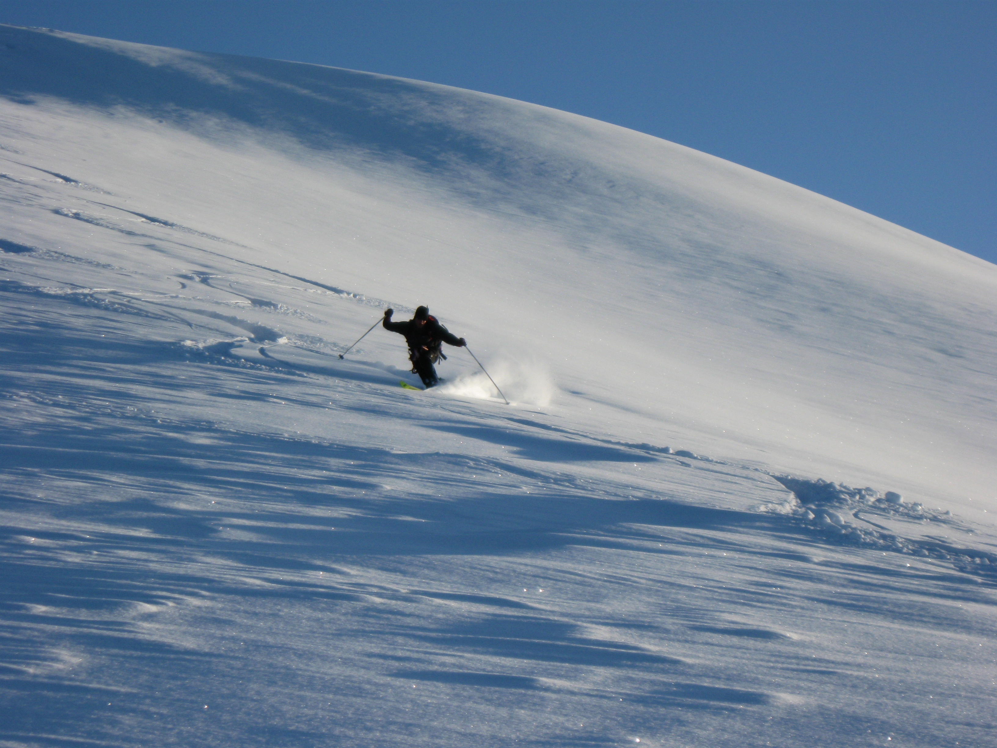
Tele sweetness coming down Kumkan
It was borderline orgasmic.It was getting dark but we both knew we just had to get more, so we skinned across to Kumkan SE1, and indulged in some more light fluffiness before gliding back to camp.
The next day we slept in until 7am, and after discovering that the weather hadn’t entirely collapsed as we expected, scrambled to get going towards Kwoiek Peak as fast as possible (2736 m according to Bivouac, but Baldwin claims Kwoiek is higher than Kumkan…). Kwoiek Peak proved nice yet uneventful, although its large summit cairn was a sign that many others (or a very enthusiastic few) had chosen to go up it before us.
Sometime the previous day Artem and I had been discussing our climbing objectives for the trip. I said:
“Mehatl is the furthest and hardest, so I’ll be OK not climbing it on this trip if we bag everything else of significance closer to Log Creek”
Artem looked at me like I was talking gobbledygook:
“Yeah, that’s exactly why I want to climb it!”
Now we were standing on the summit of Kwoiek Peak staring at Mehatl, and Mehatl was staring at us. The weather was perfectly gorgeous. What else could we do? Around Kwoiek and down the Rutledge glacier we went. 450 m down, 300m up to the col on the W side of Mehatl. I had read that this was a route up the mountain, but we hadn’t actually been able to see it from Kwoiek Peak, and now it looked steep, imposing and scary. Well, if you don’t try you don’t know. We bootpacked up a steepish slope to get onto the summit ridge proper, and then wove a winding route through rime covered rocks up to the summit. It felt amazing – it looked hard, but wasn’t. The crux of the route involved Artem digging through a mini-cornice that was a few feet wide but as tall as Artem. When it was my turn to climb Artem gave me a hand and pulled my ass up the near-vertical step of sugariness. Ah, old age and the benefits thereof!
We didn’t spend too long on the summit because the weather did start indicating it might change for the worse sometime soon. We took a few photos of Tiara Tower, an amazing rock pinnacle adjacent to Mehatl (lower but far gnarlier, and even more of a slog to get to, but allegedly with solid rock. Skyler..?). We also gazed proudly at “Longslog”, now almost 10 km behind us. That’s how sloggy we were! We retraced our steps back down Mehatl, and skied around the S side of Kwoiek instead of the previous N side to shorten the route and avoid some unpleasant windslab we had encountered on the other slope.
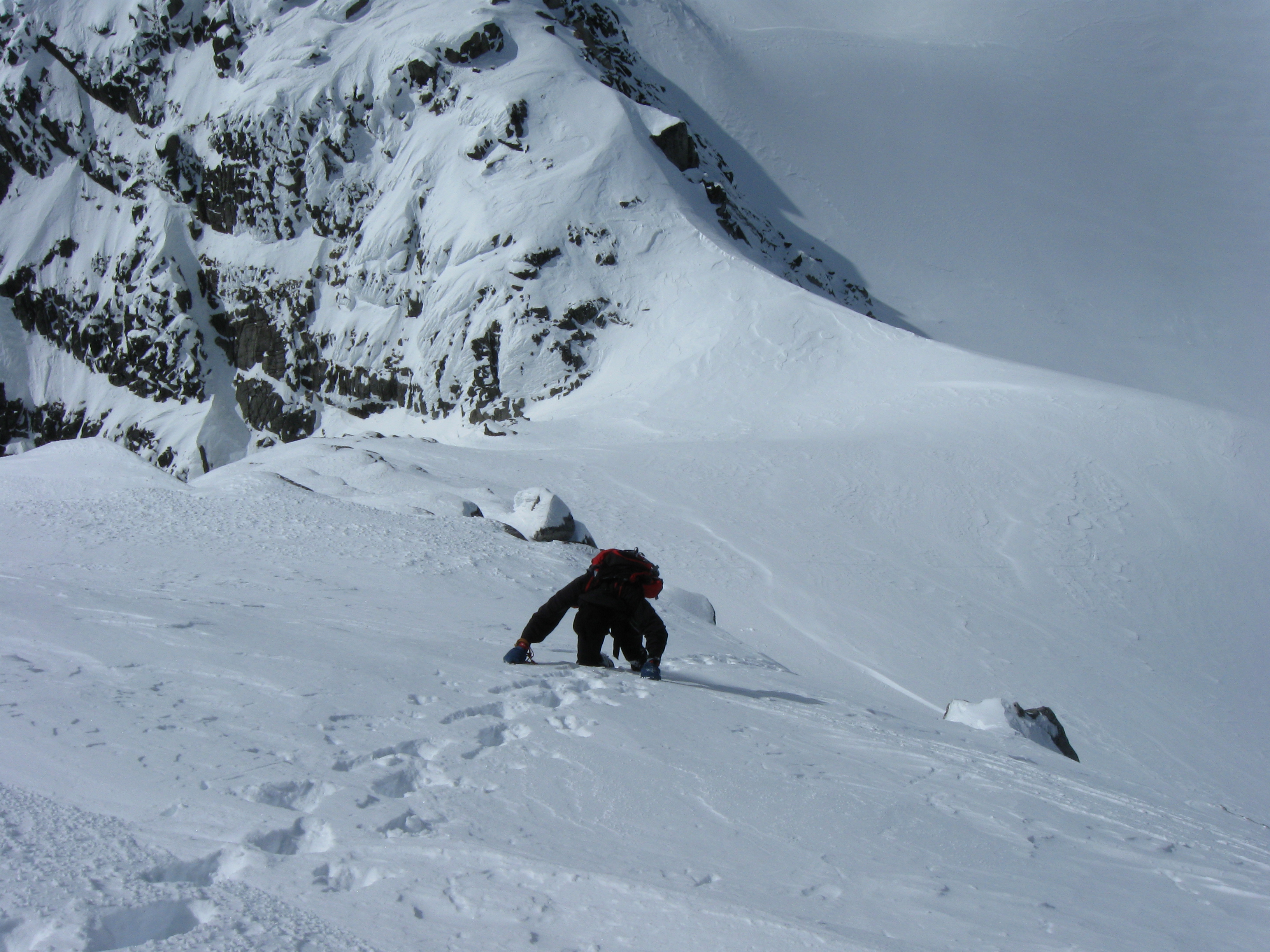
Descending Mehatl peak, final steep section before returning to the W col
Camp, dinner, mmm, zzz, zzz.
We got up early the next morning, were moving shortly after first light, and skied back to the base of Tachewana (across from Longslog). We left our overnight stuff at the base and skinned up to the summit. The broad N face had somehow gotten somewhat wind and sun affected, which made it rather unpleasant to skin up, and forced us to take the most conservative run down. Once down we reclaimed our overnight gear, and skied down the tongue of the Chociwa glacier back towards Log Creek. We had considered attempting a committing traverse out over Kwoiek Needle, but it seemed like too serious a proposition for our last day, and for carrying all of our stuff with us but no actual technical gear.
The top of the glacial tongue was still pretty good skiing. The bottom was crusty, but manageable. The gully – the gully was awful; absolutely terrible. It’s fairly narrow, its length measurable in a few ski lengths.Artem had broken trail up it with about a zeon switchbacks, and our 3-day old skintrack was now frozen solid and surrounded by deep and slushy yet still icy and crusty stuff that tried to pass for snow. Artem efficiently improvised some paramark turns down the run; I got down by means of cursing and collapsed in a heap once we got down to some safe(ish) oldgrowth.Yay – only 15 km back to the car!
The logging road wasn’t actually that bad. It’s flattish at first, and the last 8 km or so are all decently downhill. We reclaimed my vehicle, drove up the Nahatlatch a little bit further to Frances lake, and polluted its icy waters with our bodily nastiness by splashing around in it. We felt a lot better afterwards. We had lunch/dinner at the restaurant in Boston Bar and drove back to Vancouver, gaping in awe at Cheam along the way.
SUMMARY:
This is an awesome area that I think is seldom visited and deserves more attention than it gets. Granted we had perfect timing for snow levels on the Log Creek logging road, but I’m sure it’ll still be ‘reasonable’ for a little while (one won’t have to carry their skis for too long up the road). The views from the summits up high are amazing and quite ‘novel’ for the “Hway 99, Coquihalla or Manning Park” oriented folk. One can, for example, see Harrison Lake and Mt. Breakenridge quite clearly – which, by the way, looks impressive and amazing.
Kumkan proved to be one of my favourite summits on the trip, although Mehatl takes first place for its feel-good factor (climb looks hard but isn’t really). We did it with 1 ice axe each and nothing else. Longslog and/or Tachewana could conceivably be weekend tripped, if you’re willing to slog a wee bit for the sake off climbing a mountain called “Longslog”. Who wouldn’t?The gully to gain the glacier is steep and exposed to some avi hazard from far above, so on a weekend trip one would have to go up insanely early to still come down at a reasonable hour.
One day I would like to do a traverse from there across a couple valleys and a few more peaks to Lizzie - the winter Stein traverse. It looks neat.
More of my photos available at: http://www.ubc-voc.com/gallery/v/pforysinski/Chociwa/
NOTE: certain elements of the story have been slightly dramatised for better effect… I confess. Artem did in fact familiarise himself with the route somewhat before we got to the trailhead, and we did leave a trip plan with his dad and with my roommates. With no distances to go with the list of desired peaks, of course,
Wow, I was completely oblivious of this area. The concept of a winter stein really interests me though. Looks like a nice glacier with tons around it. Reminds me of the Joffre group and Matier Glacier
Bivouaced it. Yes. It actually looks awesome as a nasty winter mixed climb too.
Cool trip! Way to keep it obscure.
Nummy area – thanks for bringing back some fine memories.
We did the Stein divide traverse (Lizzie to Log creek) on skis in the summer of 2003 …. a Robin McKillop special (can’t believe he convinced us to go!) 9 days starting late June into early July. To this day it’s one of the more memorable ski traverses.
With all the high-elevation north facing glaciers (second largest contiguous glaciated area this side of the Lillooet Icefield) it’s totally feasible… even 2 months from now!
The gulley you skied up/down to access the Chochiwa was not in play for us – I think we came down on the treed nose a little to skiers left: Steep and bushy.
Other highlights included skiing above the impossibly blue Elton Lake, and scrambling the south ridge of Kwoiek Needle (Top 5 all time scramble).
Markus Kellerhals led a VOC trip across the Stein Divide on foot… written up in an early 1990′s (1993 maybe?) issue of the VOCJ. Randy Stoltmann traversed some of this terrain and wrote it up in his classic, “Written by the Wind.”
Super stunning area that sees very little traffic. Deserves way more attention!!!